17TH C. ENGLISH LINEAR MAP BY OGILBY, FRAMEDThomaston Place Auction Galleries4.4(386)See Sold PriceFeb 24, 2024
MAP - PIETER SCHENK / VALK / JANSSEN Hand Colored superb Map Central Italy c1702Luis Porretta Fine Arts4.3(10)See Sold PriceMar 02, 2024
OGILVY & BOWEN c1736 Original Map of Oxfordshire Berkshire Etc.Luis Porretta Fine Arts4.3(10)See Sold PriceMar 02, 2024
CHARLES ROLLIN c1828 Ceasar Hand Colored Africa Military MapLuis Porretta Fine Arts4.3(10)See Sold PriceMar 02, 2024
MAP - Dufour, A. H. ( Malte / Brun ) :MAP - ESPAGNE PARTIE SUD DIVISEE EN PROVINCES ANCIENNES ( MAPLuis Porretta Fine Arts4.3(10)See Sold PriceMar 02, 2024
RIGOBERT BONNE c1787 Original Colored Map Germany & Region 15" x 12"Luis Porretta Fine Arts4.3(10)See Sold PriceMar 02, 2024
AMBROISE TARDIEU c1822 Napoleonic War Map GermanyLuis Porretta Fine Arts4.3(10)See Sold PriceMar 02, 2024
MAP - AMBROISE TARDIEU c1822 Napoleonic Miltary Map GermanyLuis Porretta Fine Arts4.3(10)See Sold PriceMar 02, 2024
1822 Rare Map by Ambroise Tardieu Napoleon Caldiero Battle of Vento 17" x 11Luis Porretta Fine Arts4.3(10)See Sold PriceMar 02, 2024
THOMAS MOULE 1837 Colored Map of Warwickshire Framed vgcLuis Porretta Fine Arts4.3(10)See Sold PriceMar 02, 2024
PIETER SCHENK / VALK / JANSSEN Hand Colored Map of Rhodes Greece ca1702 vgcLuis Porretta Fine Arts4.3(10)See Sold PriceMar 02, 2024
STICH & DRUCK c1888 Map Austrian Alps 20" x 16"Luis Porretta Fine Arts4.3(10)See Sold PriceMar 02, 2024
van der Aa: Antique Map, View of Ancient Syracuse, 1725Title: Delineatio Syracusarum Antiquarium Quadriurbium, Rare 1725 bird's-eye-view of ancient Syracuse, Sicily Map maker: Pieter van der Aa Place and Year: Amsterdam, c. 1725 Dimensions: 35 x 46 cm (13See Sold Price
van der Aa: Antique View of Ancient Syracuse, SicilyTitle: Delineatio Syracusarum Antiquarium Quadriurbium Map maker: Pieter van der Aa Place and Year: Amsterdam, c. 1725 Dimensions: 35 x 46 cm (13.8 x 18.1 in) Technique: Copperplate engraving ColoringSee Sold Price
van der Aa: Antique View of Potosi, Bolivia, 1707Map: La Ville de Potosi, en Perou Cartographer: van der Aa Place & Date: Leiden / 1707 Size: 13 5/8" x 11 1/4" Condition: b&w; a repaired tear in the wide left margin; some wrinkling and fraying alongSee Sold Price
Soldvan der Aa: Antique View of Potosi, BoliviaMap: La Ville de Potosi, en Perou Cartographer: van der Aa Place & Date: Leiden / 1707 Size: 13 5/8" x 11 1/4" Condition: b&w; a repaired tear in the wide left margin; some wrinkling and fraying alongSee Sold Price
Map of the Strait of Gibraltar - Antique steel engraving - Pieter Van der Aa (Alvarez de Comenar).Map of the Strait of Gibraltar Title: Le Détroit de Gibraltar. Description: Le Détroit de Gibraltar, with two additinal views, Profil de la Montagne de Gibraltar entre L’Orient de le NSee Sold Price
Soldvan der Aa: Antique Map of Southeast US, 1713Map: La Floride Suivant les Nouvelles Observations de Messrs. de l'Academie Royale des Sciences (eastern seaboard to New Mexico) Cartographer: van der Aa Place & Date: Leiden / 1713 Size: 14 7/8" x 10See Sold Price
Soldvan der Aa: Antique Map of Southeast East Indies, 1729Map: La Partie des Indes Orientales vers le Zud-Est Cartographer: Pieter vander AA Place & Date: Leiden / 1729 Size: 13 1/2" x 11 1/2" Condition: outline color; light overall age toning A classic mapSee Sold Price
van der Aa: Antique Map of Venezuela / Guyana, 1715Map: TLandschap Cumana Tussen Golfo de Venezuela en Rio de Paria Gelegen Cartographer: Van der Aa Place & Date: Leiden / 1715 Size: 13 1/2" x 8 3/4" Condition: wash color; edges of wide top and bottomSee Sold Price
van der Aa: Antique Map of Venezuela / Guyana, 1715Map: TLandschap Cumana Tussen Golfo de Venezuela en Rio de Paria Gelegen Cartographer: Van der Aa Place & Date: Leiden / 1715 Size: 13 1/2" x 8 3/4" Condition: edges of wide top and bottom margins fraSee Sold Price
van der Aa: Antique Map of North Africa, 1730Map: Barbarie, Biledulgerid, (autrefois Libye) et une partie du Pays des Negres, suivant les observations des plus fideles Voyageurs, nouvellement publiez par Pierre Vander Aa, Marchand Libraire a LeiSee Sold Price
van der Aa: Antique Map of Naples Bay, 1719Title: 1719 c. van der Aa Map of Naples Bay -- Amoenissimae Regionis Puteoli… Cartographer: P van der Aa Year / Place: 1719 c. Map Dimensions: 11.5 X 16 in. Condition: Excellent. Sharp image. Nice tSee Sold Price
van der Aa: Antique Map of Naples Bay, 1719Title/Content of Map: 1719 c. van der Aa Map of Naples Bay -- Amoenissimae Regionis Puteoli… Date Printed: 1719 c. Cartographer: P van der Aa Size: 11.5 X 16 in. This is a well crafted map of PuteolSee Sold Price
van der Aa: Antique Map of Naples Bay, 1719Title/Content of Map: 1719 c. van der Aa Map of Naples Bay -- Amoenissimae Regionis Puteoli… Date Printed: 1719 c. Cartographer: P van der Aa Size: 11.5 X 16 in. Condition: Excellent. Sharp image. NSee Sold Price
van der Aa: Antique Map of Naples Bay, 1719Map: 1719 c. van der Aa Map of Naples Bay -- Amoenissimae Regionis Puteoli… Date Printed: 1719 c. Cartographer: P van der Aa Size: 11.5 X 16 in. Condition: Excellent. Sharp image. Nice thick paper sSee Sold Price
Soldvan der Aa: Antique Explorers Map of the Atlantic OceanTitle: H. Benzos Scheep-togt uit Italie over Spanje na de Westindize Eylanden, en Kusten van't Zuider America. Lovely 1707 explorers' map set in a decorative border Map maker: Pieter van der Aa PlaceSee Sold Price
SoldAntique view of Cadiz - 1715 - Antique steel engraving - Pieter Van der Aa (Alvarez de Comenar)Antique view of Cadiz. Title: 'Veue de Cadix du cote du Port' Published by: Pieter van der Aa (Leiden, 1659 – Leiden, 1733) Provenance: Delices de Espagne et Portugal, published in Leiden (NetheSee Sold Price
1670 Aquatint Map View of Suzhou ChinaHand water colored copper engraving by Pieter Van Der Aa. Van Der Aa (1659-1733) was a Dutch publisher of maps and atlases. Dimensions are: image - 12 1/2" wide x 7 13/16" high, overall - 15" wide x 1See Sold Price
Antique view of Gibraltar - 1715 - Antique steel engraving - Pieter Van der Aa (Alvarez de Comenar)Antique view of Gibraltar. Title: 'Vue de Gibraltar' Published by: Pieter van der Aa (Leiden, 1659 – Leiden, 1733) Provenance: Delices de Espagne et Portugal, published in Leiden (Netherlands) 1See Sold Price
Antique view of Cadiz - 1715 - Antique steel engraving - Pieter Van der Aa (Alvarez de Comenar)Antique view of Cadiz. Title: 'Veue de Cadix du cote du Port' Published by: Pieter van der Aa (Leiden, 1659 – Leiden, 1733) Provenance: Delices de Espagne et Portugal, published in Leiden (NetheSee Sold Price
Antique view of Gibraltar - 1715 - Antique steel engraving - Pieter Van der Aa (Alvarez de Comenar)Antique view of Gibraltar. Title: 'Vue de Gibraltar' Published by: Pieter van der Aa (Leiden, 1659 – Leiden, 1733) Provenance: Delices de Espagne et Portugal, published in Leiden (Netherlands) 1See Sold Price
Antique map of Andalusia and Grenade (Spain) - 1715 - Antique steel engraving - Pieter Van der AaAntique map of Ansalusia and Grenade in Spain Title: 'Nouvelle carte d'Andalusie et Granade avec les grands chemins' Published by: Pieter van der Aa (Leiden, 1659 – Leiden, 1733) Provenance: DelSee Sold Price
Sold[England/Maps & Views]. Beeverell, James.[England/Maps & Views]. Beeverell, James. Les Delices De La Grand Bretagne, & De L'Irlande. 8 Vols. A Leide: Pierre Vander Aa, 1707. Sm 8vo. Early paper boards, tan leather spine labels; soiled, moderSee Sold Price
View of Barcelona, Spain - Antique print - Pieter Van der Aa, 1715View of Barcelona, Spain Title: Le profil de la Ville et cité de Barcelonne, Capitale de la Province de Catalogne. Published by: Pieter van der Aa (Leiden, 1659 – Leiden, agosto de 1733) PrSee Sold Price
SoldFramed antique black and white map of China and KFramed antique black and white map of China and Korea by P. Vander, AA, From Van der AA's Nouvel Atlas, published in Leiden, 1714, map measures 9" high x 12" w. Was originally purchased form JonathanSee Sold Price
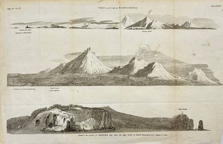
Antique Print with Coastal Views of Kamchatka in Russia by Cook, 1803Proverde Auctions4.3(3)See Sold PriceFeb 28, 2024


![[England/Maps & Views]. Beeverell, James. (1 of 0)](https://p1.liveauctioneers.com/dist/images/placeholder.jpg?height=282&quality=70)