1952 ROBERT F. KENNEDY HANDWRITTEN LETTERJohn McInnis Auctioneers,LLC4.6(502)See Sold PriceFeb 25, 2024
CASED PRESENTATION HALF HULL MODEL OF THE BARQUE "HAWTHORNBANK" Last Quarter of the 19th CenturyEldred's4.7(409)See Sold PriceFeb 27, 2024
Lot Of 14 Jack Daniels And Country Club Glass Spirit BottlesRbfinearts4.4(571)See Sold PriceFeb 24, 2024
PR OF 17TH C. SPANISH BRASS CANDLESTICKSThomaston Place Auction Galleries4.4(386)See Sold PriceFeb 24, 2024
Lake Shore and Michigan Southern RR Special Excursions Timetable-July 7-13, 1892JM Hobby Supply and Railroad Artifact Auctions4.4(126)See Sold PriceFeb 24, 2024
Tiffany & Co. Sterling Silver Corkscrew Bottle OpenerSJ Auctioneers4.5(165)See Sold PriceMar 03, 2024
Rolls Royce Landau c1950s Gin/ Scotch TantalusPasadena Antique Auctions4.3(6)See Sold PriceMar 10, 2024
US Navy Map of the Gulf of Mexico, 1870U.S. Navy Hydrographic Office. Gulf of Mexico, West Indies and Caribbean Sea from the Most Recent Spanish and British... Lithographed map. 1870. 23 ¾" x 35 ¾" sheet. With four inset harbor chartSee Sold Price
Gulf of Mexico, West Indies and Caribbean Sea. from the Most Recent Spanish and British AdmiraltyPublication Date: 1870-07-01 Title: Gulf of Mexico, West Indies and Caribbean Sea. from the Most Recent Spanish and British Admiralty Charts. Sheet V. Cartographer: ANONYMOUS Publisher: U.S. NAVY. HYDSee Sold Price
Gulf of Mexico, West Indies and Caribbean Sea. from theTitle: Gulf of Mexico, West Indies and Caribbean Sea. from the Most Recent Spanish and British Admiralty Charts. Sheet V. Publication Date: 1870-07-01 Publisher: U.S. NAVY. HYDROGRAPHIC OFFICE Size: 2See Sold Price
Gulf of Mexico, West Indies and Caribbean Sea. from theTitle: Gulf of Mexico, West Indies and Caribbean Sea. from the Most Recent Spanish and British Admiralty Charts. Sheet V. Publication Date: 1870-07-01 Cartographer: ANONYMOUS Publisher: U.S. NAVY. HYDSee Sold Price
Two Very Scarce U.S. Navy Sea Charts of Gulf of MexicoU.S. Navy Hydrographic Office. Gulf of Mexico, West Indies and Caribbean Sea from the Most Recent U.S. Coast Survey Spanish and British Admiralty Charts Sheet I. Lithogaphed map with hand color. 1869.See Sold Price
Gulf of Mexico, West Indies and Caribbean Sea. from theTitle: Gulf of Mexico, West Indies and Caribbean Sea. from the Most Recent Spanish and British Admiralty Charts. Sheet V. Cartographer: ANONYMOUS Publisher: U.S. NAVY. HYDROGRAPHIC OFFICE Height: 23.8See Sold Price
American Sea Chart of S. Florida, Keys & Bahamas WithBritish & American Surveys. Bahama Banks and Gulf of Florida, Sheet 1. Lithographed Map. U.S. Navy Hydrographic Office, 1870. 38" x 48 ½" sheet. "by J.R. Rodgers Lt. U.S.N." Shows southern 2/3 of FSee Sold Price
Central America Cabo La Vela to ChagresTitle/Content of Map: Central America Cabo La Vela to Chagres Date Printed: 4/1/1973 Cartographer: U.S. NAVY MAP SERVICE Size: 26X38 "with the southern coast shewing the GULF OF PANAMA compiled chieflSee Sold Price
SoldUnique Civil War US Navy ID Tag Carved From a 'SUnique Civil War US Navy ID Tag Carved From a 'Sea Heart'. The sea heart is the fruit ofSee Sold Price
SoldRaphael Semmes SERVICE AFLOAT AND ASHORE DURING THERaphael Semmes SERVICE AFLOAT AND ASHORE DURING THE MEXICAN WAR 1851 Very Rare Antique US History Navy Battles Mexico Fold‾Out Map Engraved Illustrated Plates Geography Santa Anna Texas San JaciSee Sold Price
SoldMap of the River Sabine surveyed in 1840Heading: (Texas) Author: U.S. Government Title: Map of the River Sabine from its Mouth on the Gulf of Mexico in the Sea to Logan's Ferry...Shewing the Boundary between the United States and the RepublSee Sold Price
SoldBorder between Texas & Mexico 1842Heading: (Texas) Author: U.S. Government Title: Map of the River Sabine from its Mouth on the Gulf of Mexico in the Sea to Logan's Ferry...Shewing the Boundary between the United States and the RepublSee Sold Price
SoldHand-Colored Lithograph Map of the Gulf of MexicoImpressive Hand-Colored Lithograph Map of the Gulf of Mexico, titled "U.S. Coast Survey, A.D. Bache Superintendent, Sketch H, Showing the Progress of the Survey in Section No. 8, 1846-1854", the map iSee Sold Price
SoldA lot of ten mid 19th century U.S. Coast Survey maps10 (Ten) mid 19th century coast survey maps, some in color, including the Gulf of Mexico, the west coast of Florida, Bulls to St. Helena sound, Mobile Bay, St. Louis Bay, and others, dimensions 6.5inSee Sold Price
Maps & Charts of LouisianaMaps & fishing charts of Louisiana: large photo of the Gulf of Mexico, chart of Mississippi River to Galveston, Chart of Allens to Pensacola Cay, chart of Chandeleur & Breton Sound, Us Gulf Coast mapSee Sold Price
Seutter Map of Mexico Southern US & Gulf 1700sMappa Geographica Regionem Mexicanam et Floridam. By Matthaeus Seutter. Hand-colored copper plate engraving, circa early 18th c. 20 x 24" plate size. Some tears at bottom and a few other margins.See Sold Price
Osaka, Kobe & Hiogo, Japan With Street Plans 1886Bartlett, J. R. Japan. Gulf of Osaka. Hiogo and Osaka. Lithographed map. Hydrographic Office, U.S. Navy, 1886. 17" x 22 ½" sheet. With two insets. Plan of city of Osaka. Soundings. Scarce.See Sold Price
West Indies With The Gulf of Mexico and Caribbean SeaTitle/Content of Map: West Indies With The Gulf of Mexico and Caribbean Sea Date: 1892-06-01 Cartographer: CLOVER, RICHARDSON Publisher: HYDROGRAPHIC OFFICE, BUREAU OF NAVIGATION, NAVY DEPARTMENT SizeSee Sold Price
West Indies With The Gulf of Mexico and Caribbean SeaTitle/Content of Map: West Indies With The Gulf of Mexico and Caribbean Sea Date: 1892-06-01 Cartographer: CLOVER, RICHARDSON Publisher: HYDROGRAPHIC OFFICE, BUREAU OF NAVIGATION, NAVY DEPARTMENT SizeSee Sold Price
West Indies With The Gulf of Mexico and Caribbean SeaTitle/Content of Map: West Indies With The Gulf of Mexico and Caribbean Sea Date Printed: 06/01/1892 Cartographer: CLOVER, RICHARDSON Size (inches): 20.75X34 Highly detailed official navy chart with sSee Sold Price
SoldU S Coast Survey 1896 LG Map. New Orleans Texas Florida"Sketch of General Progress June 30. 1896" Showing Southern, Eastern and Mid West States, incl Florida, Texas, Gulf of Mexico, Georgia etc. Large Lithograph Map Published 1896, Washington for "U.S. CoSee Sold Price
Map of the Straits of Florida and Gulf Of MexicoTitle: Map of the Straits of Florida and Gulf Of Mexico Publication Date: 1852 Cartographer: ANDREWS, ISRAEL D. Publisher: U.S. COAST SURVEY Size: 26.5X34.25 to accompany a report from the Treasury DeSee Sold Price
Map of the Straits of Florida and Gulf Of MexicoTitle: Map of the Straits of Florida and Gulf Of Mexico Publication Date: 1852 Cartographer: ANDREWS, ISRAEL D. Publisher: U.S. COAST SURVEY Size: 26.5 x 34.25 to accompany a report from the TreasurySee Sold Price
Rare Map of Sabine River, TexasMap of the River Sabine from its Mouth on the Gulf of Mexico in the Sea to Logan’s Ferry. Drawn by Lieut. T. J. Lee, U.S. Topographical Engineers. Engraved by W.J. Stone. Lithograph in 5 Parts. IssuSee Sold Price
AIRPLANE MODEL Boeing F-18 Hornet Blue Angels US NAVY Diecast ModelSJ Auctioneers4.5(165)See Sold PriceMar 03, 2024
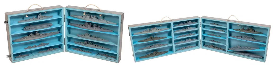
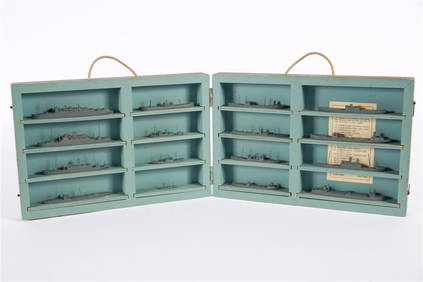
CASED SET OF WORLD WAR II-ERA U.S. NAVY RECOGNITION/TEACHING MODELS OF AMERICAN SHIPS 20th CenturyEldred's4.7(409)See Sold PriceFeb 27, 2024
TWO CASED SETS OF WORLD WAR II-ERA U.S. NAVY RECOGNITION/TEACHING MODELS OF BRITISH AND FRENCH SHIPSEldred's4.7(409)See Sold PriceFeb 27, 2024
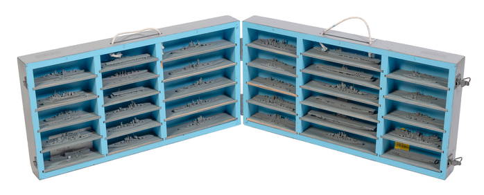
FOUR CASED SETS OF WORLD WAR II-ERA U.S. NAVY RECOGNITION/TEACHING MODELS 20th Century Model lengthsEldred's4.7(409)See Sold PriceFeb 27, 2024
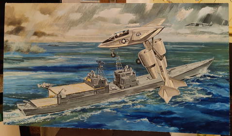
Unsigned Experimental Aircraft and Ship U.S. Navy IllustrationHeritage Gallery Auctions4.4(56)See Sold PriceMar 10, 2024
U.S. NAVY - A Complete History by Goodspeed, M. Hill 2003 MintNorth American Artifact Auctions4.6(182)See Sold PriceApr 20, 2024
South Salem Studios, US Navy Ship Model CaseStefek's Auctioneers & Appraisers4.5(105)See Sold PriceFeb 28, 2024
VARIOUS ARTISTS [WWI & WWII / U.S. NAVY, MARINES, AIR FORCE]. Group of 8 posters.Swann Auction Galleries4.4(65)See Sold PriceFeb 29, 2024


![VARIOUS ARTISTS [WWI & WWII / U.S. NAVY, MARINES, AIR FORCE]. Group of 8 posters. (1 of 5)](https://p1.liveauctioneers.com/199/319703/171640550_1_x.jpg?height=282&quality=70&version=1707943705)


![Untitled. [Eastern U.S., Gulf of Mexico and Caribbean] (1 of 5)](https://p1.liveauctioneers.com/5584/319958/171812128_1_x.jpg?height=282&quality=70&version=1708466739)