SoldMAP - Western United States. U.S. War DeptWestern United States. U.S. War Department, Map of the Yellowstone and Missouri Rivers and Their Tributaries, 1867 (dated). Black & White. A large and very detailed map of the region explored by Capt.See Sold Price
Johnson: New Military Map of the United States, 1862Johnson's New Military Map of the United States Showing the Forts, Military Posts &c with Enlarged Plans of Southern Harbors from Authentic Data Obtained at the War Department Washington. Johnson & WaSee Sold Price
SoldOld Map of 1864 United States with Civil War BoundariesOld Map entitled "Map of the United States of America Showing Boundries of the Union & Confederate Geographic Divisions and Departments Dec. 31, 1864." Printed by Julius Bien & Co. Lith, NY. Top markeSee Sold Price
SoldCivil War Era Map of the United StatesMap of the United States of America Showing the Boundaries of the Union and Confederate Geographical Divisions and Departments, June 30, 1863; Civil War Atlas; Plate 167. Julius Bien & Co., 1895.See Sold Price
SoldUnited States War Department ABSTRACT OF INFANTRYUnited States War Department ABSTRACT OF INFANTRY TACTICS INCLUDING EXERCISES AND MANOEUVRES OF LIGHT-INFANTRY AND RIFLEMEN FOR THE USE OF THE MILITIA OF THE UNITED STATES 1830 Antique Leatherbound IlSee Sold Price
SoldLot of United States War Department Manual, World War II Pilot Cap, Wicker Basket, Crystal Glass,Lot of United States War Department Manual, World War II Pilot Cap, Wicker Basket, Crystal Glass, Crochet Coasters, Plates, and MoreSee Sold Price
SoldUNITED STATES WAR DEPARTMENT - CIVIL WAR - UNIFORMS, USUnited States War Department - Civil War - Uniforms, Us And Confederate Armies, 1895 - 36 X 22 1/2 In. - Giclée Print - Gallery Stretched - Ready to hang.See Sold Price
Sold(A) Doc Martial Colt Mod 1860 Percussion Revolver.Serial # 65580 8” barrel in .44 percussion. Factory letter states that this Martially marked Colt Model 1860 Army was shipped to the United States War Department, Major. R.H.K. Whitley, New York ArsSee Sold Price
SoldWorld At War Map : United States As A World PowerThe World War Historical Map by Sanford – Gordy. Map shows the Nations At War. The League Of Nations and the United States As A World Power, After the Spanish American War. Colonial with PossessionsSee Sold Price
Sold[Map] United States Department of Interior[Map] United States Department of Interior , "Plan and Profile of Colorado River from Leese Ferry, Ariz, to Black Canyon, Ariz, Nev, and Virgin River", 1923, 18 in. x 25 in (21pcs) Provenance: PropertSee Sold Price
Sold10 Antique War Department/Survey Maps of the West[Ten Antique War Department/Survey Maps of the Western United States], 19th c., incl. "Sketch of the Country...of Kansas", "Colorado Territory"; "From the Pimas Villages to Fort Fillmore", "From FortSee Sold Price
SoldPhelps: Antique Pre-Civil War Map of United States 1848Patriotic Antique Pre-Civil War US Map; "Phelps's National Map of the United States, A Travellers Guide. Embracing the principal Rail Roads, Canals, Steam Boat & Stage Routes, Throughout the Union.".See Sold Price
Johnson: Antique Civil War Map of United States, 1864Title/Content of Map: 1864 Johnson Map of the United States -- Johnson's United States Date Printed: 1864, New York Cartographer: A Johnson Size: 16.9 x 23.1 in. This is a large, highly detailed CivilSee Sold Price
SoldLarge Civil War map of United States 1863Heading: (United States - Civil War) Author: Lloyd, James T. Title: Lloyd's New Map of the United States, the Canadas and New Brunswick from the Latest Surveys Showing Every Railroad & Station FinisheSee Sold Price
SoldUnited States. Civil war era military map. ShowingTitle/Content of Map: United States. Civil war era military map. Showing southern ports Date: 1863 Cartographer: By Johnson & Ward. From, Johnson’s New Illustrated Family Atlas Size: 18x 26 1/4”.See Sold Price
SoldGeorge Cram: United States Civil War 1889Map: United States Civil War (1860-1865) Maker: George Franklin Cram Publishing: Chicago Date: 1889 Size: 11.5 x 14.5 inches Medium: Color lithograph From Cram's Unrivaled Atlas of the World George F.See Sold Price
Sold1861 Colton United States Map with Civil War MilitaryTitle/Content of Map: 1861 Colton United States Map with Civil War Military Stations -- Colton's United States Shewing the Military Stations Forts &c. Date: 1861, New York Cartographer: J Colton Size:See Sold Price
SoldCIVIL WAR UNITED STATES HOSPITAL DEPARTMENT MEDICINECIVIL WAR UNITED STATES HOSPITAL DEPARTMENT MEDICINE BOTTLE, bright yellow olive green, quart, cylindrical form embossed "U . S . A / HOSP DEPT", applied rounded mouth with lower collar, plain base wiSee Sold Price
Sold1861 Colton United States Map with Civil War MilitaryTitle: 1861 Colton United States Map with Civil War Military Stations -- Colton's United States Shewing the Military Stations Forts &c. Cartographer: J Colton Year / Place: 1861, New York Map DimensioSee Sold Price
SoldColton's Civil War map of the United States 1862Heading: (Maps) Author: Colton, J.H. Title: Colton's United States Showing the Military Stations, Forts &c. Place Published: New York Publisher: Date Published: 1862 Description:See Sold Price
SoldPortfolio Containing 21 Topographic MapsDESCRIPTION: Portfolio containing twenty-one topographic maps. Includes seventeen maps by the United States Department of the Interior Geological Survey of the State of Massachusetts and five of the SSee Sold Price
SoldCORRESPONDENCE RELATIVE TO THE PRESENT CONDITION OFCORRESPONDENCE RELATIVE TO THE PRESENT CONDITION OF MEXICO COMMUNICATED TO THE HOUSE OF REPRESENTATIVE BY THE DEPARTMENT OF STATE 1862 United States Civil War Era Decorative William H Seward Thomas CoSee Sold Price
SoldCivil War Era Map of the United States by J. H. Colton,Antique Original 1860 J. H. Colton Map of the United States | Publisher: New York, J. H. Colton, 1860 | Verso contains an original 1860 J. H. Colton map of Maine and New Hampshire | Map of the UnitedSee Sold Price
SoldCivil War Era Map of the United StatesMap of the United States and Territories. Henry F. Walling (1825 - 1889) & Ormando W. Gray (fl. 1860 – 1880). Lithographed Map. Boston, 1871. 17 x 25 1/2 inches sheetSee Sold Price
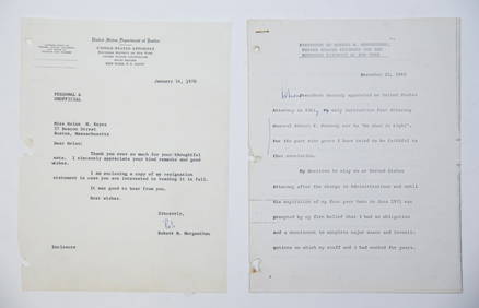
1969 RESIGNATION of ROBERT M. MORGENTHAUJohn McInnis Auctioneers,LLC4.6(502)See Sold PriceFeb 25, 2024
United States Map with American Flag 3-D Wall Mount PaintingWeatherham Estate Treasures3.9(157)See Sold PriceFeb 29, 2024
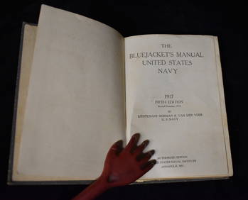
The Bluejacket's Manual United States Navy 1917 (World War I manual)North American Artifact Auctions4.6(182)See Sold PriceApr 20, 2024
President Wilson Fights His War: World War I 1st Edition 1st Printing 1968North American Artifact Auctions4.6(182)See Sold PriceApr 20, 2024
Over There: The United States in the Great War, 1917-18 1st EditionNorth American Artifact Auctions4.6(182)See Sold PriceApr 20, 2024
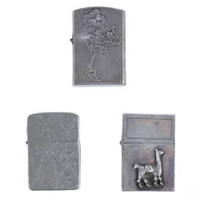
Vietnam War Era Silver Cigarette Lighters 3pc LOTHill Auction Gallery 4.7(1k)See Sold PriceFeb 28, 2024
[CIVIL WAR - UNITED STATES COLORED TROOPS]. A group of 4 documents related to officers of USCT andFreeman's | Hindman4.4(1.6k)See Sold PriceFeb 27, 2024
1905 20th Century Atlas of Boone County IllinoisMatthew Bullock Auctioneers4.7(1.8k)See Sold PriceFeb 24, 2024
Putnam - First Map of the State of Ohio by Rufus PutnamTrillium Antique Prints & Rare Books4.5(30)See Sold PriceFeb 24, 2024
Cooke, George 1801 Antique Map. United States of AmericaAlbion Auctions4.6(336)See Sold PriceMar 01, 2024
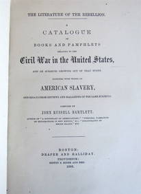
1866 BOOK CATALOGUE: UNITED STATES' CIVIL WAR HISTORY ANTIQUE AMERICANANY Elizabeth 4.3(84)See Sold PriceMar 03, 2024
8PC United States Police Department Guide BooksBruneau & Co. Auctioneers4.5(491)See Sold PriceMar 18, 2024
Map of United States of North America, 1785Antiques Online Auctions4.6(407)See Sold PriceMar 14, 2024


![[Map] United States Department of Interior (1 of 2)](https://p1.liveauctioneers.com/268/180010/90586238_1_x.jpg?height=282&quality=70&version=1600794544)


![[CIVIL WAR - UNITED STATES COLORED TROOPS]. A group of 4 documents related to officers of USCT and (1 of 4)](https://p1.liveauctioneers.com/197/319238/171468129_1_x.jpg?height=282&quality=70&version=1707520367)