SoldTwo Maps of Eretz Israel, 16th century1. Terra Sancta XVI nova tabula [Modern map of Palestine 16th century], Sebastian Münster. Basel, 1542. Colored woodcut. Eretz Israel spans on both sides of the Jordan River according to the TribesSee Sold Price
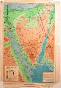
Lot of 5 Maps of Eretz Israel, 19th-20th CenturyLot of 5 maps of Eretz Israel (Palestine), 19th-20th century. Including a map of Jerusalem, a large framed map of Eretz Israel (glass broken) and more. Dimensions: 25X19 - 43X35 cm. Large map in goodSee Sold Price
Two antique maps comprising a 16th century by AbrahasTwo antique maps comprising a 16th century by Abrahas Ortelius, titled 'Andegavensium Ditionis Vera Et Integra Descriptio' and early 18th century map by Caroli Sigonii, titled 'Attica Maxima Terra', bSee Sold Price
SoldTwo books of maps of Eretz Israel: 1. Jerusalem, theTwo books of maps of Eretz Israel: 1. Jerusalem, the saga of the Holy City, The Universitas publ Jlm 1954 no 947 of limited ed 2. Holy Land in maps, ed A. Tishby, The Il Museum Jlm 2001See Sold Price
SoldPalestine and Israel Map LotLarge lot of 20th century maps, Eretz Israel (Palestine) and Israel. Including Mandatory Palestine maps, maps from old atlases and more. Various sizes and conditions, overall good condition.See Sold Price
SoldTwo 16th century maps: Egypt and Africatwo early engraved maps in octavo format: 1) After Ptolemy, "Tabula Aphricae II" showing Libya, the North African shore, and Mediterranean islands, from the Universal Geography, Cologne, Keschedt, 159See Sold Price
Two Maps of the Land of Israel, 18th Century ...1. Iudaea, seu Terra Sancta quae Hebraeorum sive Israelitarum. Map of the Land of Israel on both banks of the Jordan River, showing the division of land among the tribes, by Guillaume Sanson. AmsterdaSee Sold Price
SoldTwo Pendants and a Medallion - Establishment of IsraelTwo pendants and a medallion. [Eretz Israel, 1948]. 1-2. Two pendants. Silver (marked). Obverse: Map of Eretz Israel prior to the conquest of the southern Negev, Jeep, boat and airplane. Reverse: "KiSee Sold Price
SoldAfter Christian AdrichomLate 16th century engraved map in two parts, copperplate engraving, 81 X 53 cm.,See Sold Price
Two pieces of 16th century maps. One of city Vere andTwo pieces of 16th century maps. One of city Vere and one of Old Middelburg van den Jaere 1400. Size: 34 x 28 cm. In reasonable / good condition.See Sold Price
SoldTwo Land of Israel Maps, 18th Century1. Iudaea, seu Terra Sancta quae Hebraeorum sive Israelitarum. Map of the Land of Israel on both sides of the Jordan, with division into the tribes' inheritances by Guillaume Sanson, Amsterdam,See Sold Price
Two pieces of 16th century maps. One of city Vere and one of Old Middelburg van Two pieces of 16th century maps. One of city Vere and one of Old Middelburg van den Jaere 1400. Size: 34 x 28 cm. In reasonable / good condition.See Sold Price
SoldLate 16th Century Maps, Incl. Siege of La Rochelle &Two maps on one sheet. Hand-colored map of Ghent (approx. 8.5 x 11 in.), tipped onto reverse side of page with map of the Siege of La Rochelle (approx. 8.25 x 11 in. plate size). Both maps printed witSee Sold Price
Spice Container and Tobacco Box Made of Olive WoodTwo items made of olive wood. Eretz Israel, [late 19th century]. 1. Spice container. Massive body, barrel-like, with carved images of the Western Wall and "Ir Zion". Screw-on lid, hollow, with ornamenSee Sold Price
Goblet and Spice Container Made of Olive WoodTwo objects made of olive wood. Eretz Israel, [late 19th century]. 1. Spice container. Round and hollow body on which the inscription "Besamim€ Jerusalem" (Hebrew and English) is printed. Screw-on bSee Sold Price
SoldBrass Item Lot, PalestineLot of two brass items embossed with reliefs of Palestine maps, Eretz Israel (Palestine). Including an Oppenheim ink blotter and a Klein-Kom notebook cover. Dimensions: 13.5X8 - 10.5X10 cm. Marked. MiSee Sold Price
Terra Sancta Ssive Promissionis olim Palestina. Large mTerra Sancta Ssive Promissionis olim Palestina. Large map of Eretz Israel featuring the two sides of the Jordan River divided among the twelve tries, by Frederic De Witt. Amsterdam. [Circa 1680]. 53 xSee Sold Price
Sold16th Century Map of the Holy LandPalestinae Sive Totius Terrae Promissionis Nova Descriptio Auctore Abraham Ortelius (Flemmish 1527-1598) Tilemanno Stella Sigenens. Double-plage engraved map of Israel, Palestine, the Sinai Peninsula,See Sold Price
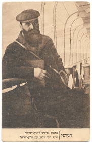
Sold Photographs from Eretz Israel, 19th Century54 photographs from Eretz Israel, end of 19th and beginning of 20th century. Among them are two large photographs, pasted on cardboard of the Damascus gate; view of the Old City; single photographs: aSee Sold Price
SoldLot of postcards with maps of Eretz IsraelLot of four rare postcards with maps of Eretz Israel, including one printed in Cairo for the Jewish Legion, one printed by Keren HaYessod in 1948 and two other postcards.See Sold Price
SoldMap of Eretz Israel in Romanian, 1948Statul Evreesc Independent Israel si Palestina [Independent Jewish State and Palestine], 1948. Romanian. Two parts. On the upper part of the map appears a historic description of settlement in Eretz ISee Sold Price
SoldTwo Albums with Artistic Bindings - 1940sTwo albums with artistic leather bindings, with embossed illustrations of the map of Eretz Israel and President Haim Weizmann. 1940s. Two albums: 34X25 cm; 33X47 cm. Good condition. Some stains and teSee Sold Price
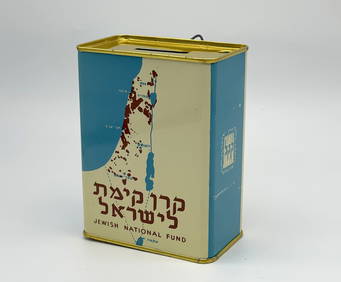
SoldTwo Jewish National Fund Collection BoxesTwo Jewish National Fund ( JNF / KKL ) blue boxes, with a map of Eretz Israel and a Jewish star.Plastic. Unknown maker, apparently Israel. Height: approximately 12 cm, base: approximately 8X2 cm. GoodSee Sold Price
SoldLot of two items made of Jerusalem OlivewoodLot of two items made of Jerusalem Olivewood in Eretz Israel, late 19th century: 1. Spice container. Carved images of the Western Wall and Jerusalem. Screw-on lid, hollow, with ornamentations of piercSee Sold Price
MAP OF SALZBURG BY GEORGE BRAUN & FRANS HOGENBURG. 1588Thomaston Place Auction Galleries4.4(386)See Sold PriceFeb 24, 2024
Jewish National Fund Collection Box - Great BritainLevy Auction House4.4(11)See Sold PriceFeb 27, 2024
Eretz Israel Map Postcard - World Zionist OrganizationLevy Auction House4.4(11)See Sold PriceFeb 27, 2024
Illustrated Sabbath Cloth - Holy Sites of Eretz IsraelLevy Auction House4.4(11)See Sold PriceFeb 27, 2024
Famous Dealer Eskenazi 2002 Two Rare Chinese porcelain fish jars of the 14th and 16th centuriesSunburst Auction4.4(17)See Sold PriceFeb 24, 2024
Willem Blaeu, Etc. 17th C. Antiquarian Maps, 2Auctions at Showplace4.5(723)See Sold PriceMar 17, 2024
Love letter from Pedro de Lanuza to Cervantes' niece, 16th centuryTemplum Fine Art Auctions4.3(8)See Sold PriceFeb 28, 2024
Folding lectern in wrought iron and fabric, Spain, 16th centuryTemplum Fine Art Auctions4.3(8)See Sold PriceFeb 28, 2024
Spectacular Great Triptych in Southern Dutch Gothic style from the 16th century, signed and datedTemplum Fine Art Auctions4.3(8)See Sold PriceFeb 28, 2024
1585 MILITARY ORATIONS by Remigio Nannini in ITALIAN antique 16th CENTURY RAREJasper524.5(9.7k)See Sold PriceFeb 27, 2024
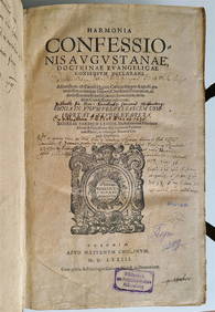
1529 BIBLE ILLUSTRATED TEXTUS BIBLIA antique FOLIO in LATIN RARE 16th CENTURYJasper524.5(9.7k)See Sold PriceFeb 27, 2024
1566-1573 Divi Caecilii Cypriani Episcopi Carthagin ANTIQUE FOLIO 16th CENTURYJasper524.5(9.7k)See Sold PriceFeb 27, 2024
Two Hand-Colored 19th Century Maps of New Orleans and Louisiana, Larger- H.- 12 1/2 in., W.- 15 1/2Crescent City Auction Gallery4.3(229)See Sold PriceMar 08, 2024
A LARGE INDIAN CARVED RED SANDSTONE SCULPTURAL PANEL possibly 15th/16th century, depicting two figurHannam's Auctioneers Ltd4.3(385)See Sold PriceFeb 27, 2024
1577 DELLA HISTORIA DI MATTEO VILLIANI VINTAGE 16TH-CENTURY ITALIAN HISTORYNY Elizabeth 4.3(83)See Sold PriceMar 03, 2024
Ex-Christie's East 14th-16th C Wood Shrine Door.Clarke Auction Gallery4.5(541)See Sold PriceMar 10, 2024
Galliae Regionis Nova Descriptio Hand Colored Map of France on Laid Paper, Ca. 16th Century, H 10" WDuMouchelles4.6(822)See Sold PriceMar 15, 2024