Claude Monet French 1840 - 1926 Oil on canvas Painting Impressionism Renoir Manet Pissarro Era.International Art Auction Gallery4.4(163)See Sold PriceFeb 24, 2024
Antique American Hudson River School Sunset Landscape Framed Original Oil PaintingCurated Gallery Auctions4.6(131)See Sold PriceFeb 25, 2024
Robert William Wood (1889 - 1979) Texas BluebonnetsPremier Auction Galleries4.3(331)See Sold PriceMar 09, 2024
BIRGER SANDZEN (1871-1954) COLORADO OIL ON CANVAS 1936Soulis Auctions4.8(953)See Sold PriceFeb 24, 2024
George Adomeit (American 1879-1964) CAPE COD LandscapePremier Auction Galleries4.3(331)See Sold PriceMar 09, 2024
Vincent Van Gogh Dutch 1853-1890 Oil on canvas. Paul Gaugin, Cezanne, Degas EraInternational Art Auction Gallery4.4(163)See Sold PriceFeb 24, 2024
Renaissance Old Master Altarpiece Adoration Magi Oil Painting Christ Child Virgin Mary Wise MenHess Fine Auctions4.5(210)See Sold PriceMar 02, 2024
19TH C GERMAN OIL PAINTING BY EMIL ZSCHIMMER C 1872Antique Arena Inc.4.5(878)See Sold PriceFeb 24, 2024
JOHN CONSTABLE ANTIQUE ENGLISH CLOUDS OIL PAINTINGAntique Arena Inc.4.5(878)See Sold PriceFeb 24, 2024
ATTRIBUTED TO GILBERT STUART (MA/RI/UK, 1755-1828)Thomaston Place Auction Galleries4.4(393)See Sold PriceFeb 24, 2024
Pablo Picasso Spanish 1881-1973 Oil On Canvas Painting Dali Magritte Braque Juan GrisInternational Art Auction Gallery4.4(163)See Sold PriceFeb 24, 2024
ATTRIB Francisco Miralles Y Galup (Spain,France,1848-1901) oil painting antiqueBroward Auction Gallery4.7(292)See Sold PriceMar 10, 2024
AMERICAN SCHOOL (Early 20th c) Two WorksJohn McInnis Auctioneers,LLC4.5(505)See Sold PriceFeb 25, 2024
Marc Chagall-Limited Edition -Paris Opera Ceiling after ChagallArt Legacy Auctions4.5(223)See Sold PriceFeb 24, 2024
SoldHenri Abraham Chatelain, two map engravings in oneHenri Abraham Chatelain, two map engravings in one frame, matted separately, "Carte Très Curieuse De La Mer Du Sud, Contenant Des Remarques Nouvelles Et Très Utiles Non Seulement Sur Les PartsSee Sold Price
SoldTwo Small Map Engravings - North & South AmericaTwo Small Map Engravings - North & South America by Thomas Kitchen circa 1790 - 8 1/4" T X 7 1/2" WSee Sold Price
SoldTWO DUTCH HAND COLORED MAP ENGRAVINGSTwo early Dutch hand colored map engravings. Both framed and matted in thin frames. The first is marked at the top right corner "Dordracvm vulgo Dortt. Me Mosa, et Walis, cum Linga, Meruaqué cingunt,See Sold Price
SoldTwo Colored Engravings of Maps and CitiesOne depicting three Spanish cities, 18th/19th C., the other a colored lithograph of Meridies Map, of Anjou. Sight size: 13-1/2"h x 18-3/4"w and 14-1/2"h x 19-1/2"wSee Sold Price
SoldRARE MAP OF NEW ENGLAND BY HOMANN FROM 1716 ATLASNew England, Johannes Baptista Homann (1664-1724) "Nova Anglia Septentrionali...." Nuremberg, 1716. Double-paged folio map, copperplate engraving on two joined sheets of wove paper, older color, slighSee Sold Price
Sold4pc Marci Velseri 17th Cent. Italian ''Tabula4pc Marci Velseri 17th Cent. Italian ''Tabula Itineraria ex Illustri Peutingerorum'' Map Engravings 24''x28'' Framed Each. Includes plates 1 through 8 each sheet with two contact maps of Italy, circaSee Sold Price
SoldWorld mapWorld map 'Nova Totius Terraum Orbis Geographica Ac Hydrographica Tabula', copper engraving map of Heinrich Hondius, dated 1630,two hemispheres the world map, surrounded by rich allegorical representaSee Sold Price
SoldNineteen framed pieces to include fox hunt, printedNineteen framed pieces to include fox hunt, printed maps, engravings, set of six Paul Merie prints, and two mirrors. sight size 6" x 5 3/4" to 18" x 29 1/2"See Sold Price
Sold2 Watercolors- John C. Bonebrake, Ashton2 Watercolors- John C. Bonebrake- Two Figures by Cathedral; Ashton- Figures on Road; both signed lower right; along with a map engraving with hand-coloring- ''Imperii Persici''; map has repair verso,See Sold Price
SoldAntique Maps (two)BRITANNIA; AMERICAE, two engravings with hand-coloring and center-fold as issued, the first published by Milliaria Gallica, frame 19 ¾ x 25” with glass, the second sight 19 ½ x 23”, frame 28 x 3See Sold Price
SoldTwo Framed Maps, after Nicolas de Fer, to includeTwo Framed Maps, after Nicolas de Fer, to include "L'Asie", and "L'Amerique Mer Méridionale et Septentrionale", each hand-colored engravings on paper, numbers 159 and 160, sight size: 9" x 12 1/2".See Sold Price
SoldGeorg Hoefnagel Hand Colored Engraving MapGeorg Hoefnagel (Belgium 1542-1601) Two plates, Turones vulgo Tours and Andegavum vulgo Angiers, from Cities of the World. Dated 1561. Crease from binding down center. 13 1/2"H x 18 1/4"WSee Sold Price
SoldMATTHAUS SEUTTER HAND COLORED ENGRAVING: MAP OF VENICEMatthaus Seutter hand colored copper engraving showing a map of Venice, circa 1730. General birds' eye view with coat of arms and two main views of the Piazza San Marco and the Piazzetta. Matted and uSee Sold Price
SoldTwo French Maps and Augustus MitchellAugustus Mitchell 1867 Map of The Austrian Empire Italian States. Turkey in Europe and Greece, Also This hand colored celestial map of the Stars and Constellations is a steel plate engraving, dating tSee Sold Price
SoldANTIQUE GERMAN MAPS, TWO PIECESANTIQUE GERMAN MAPS, TWO PIECES, H 13", W 17":Including one framed engraving depicting North America; noted in German in the upper left "After the drawing by William Delisle, published by Joh Justin GSee Sold Price
SoldFRENCH, 18TH CENTURYTwo hand colored engravings including a map, La Mer Aquitanique, together with Vue de L'hotel de Ville de Paris, framed.See Sold Price
Sold2 Volumes: Travels in Central America, 1841A two-volume set of "Incidents of Travel in Central America, Chiapas, and Yucatan" by John L Stephens, 1841. 3/4 leather bound with marbled paper. Includes maps and engravings.See Sold Price
SoldTwo Mercator / Hondius Maps2 (Gerard) Mercator atlas maps, 1619 French Edition, handcolored copperplate engravings on paper. 1st item: America "L'Amerique" by Joducus Hondius, Western Hemisphere - North and South America. ShowsSee Sold Price
SoldSTANLEY, HENRY M., IN DARKEST AFRICA, 1890, 2 VOL.Beautiful decorated covers, two steel engravings, 150 illustrations and maps, and accompanying fold-out maps in rear pockets of each volume featuring the route of the Emin Pasha Relief Expedition throSee Sold Price
SoldA Map of Jerusalem and the Temple. Braun & Hogenberg.Hierosolyma, Clarissima totius orientis Civitas Iudaee Metropolis, a copperplate engraving of a map of the ('Jewish') city from two eras: the 1st and 16th centuries. Braun & Hogenberg. Klon, 1572.See Sold Price
SoldANTIQUE NORTH AMERICA MAPS, LOT OF TWOANTIQUE NORTH AMERICA MAPS, LOT OF TWO, hand-colored copper-plate engravings, including Charles Delamarche, "Amerique Septentrionale - Dressee d'apres les Decouvertes du Cap Cook et autres Voyageurs".See Sold Price
SoldParis, And Its Historical ScenesFirst Edition. Two Volumes. Publishers green blind-stamped covers. Gilt title and vignettes to spine. Some uncut pages. Volume I. iv, 380 pages, 2 full-page engravings. Fold-out map of Paris.<brSee Sold Price
SoldWillem Blaeu Nova Virginiae TabulaDutch, c. 1640, Nova Virginiae Tabula, original engraving by Jodocus Hondius, after John Smith's 1612 map of Virginia, two sheets, black and white engraving with hand-colored highlights, decorative caSee Sold Price
SoldAFTER ANDREAS CELLARIUS (1596-1665)Three colour engravings of celestial maps from Atlas Coelestis seu Hermonia Macrocosmica. With French matting together with two unframed works. 20th C Size: 20.5 x 28 in. (approx.)See Sold Price
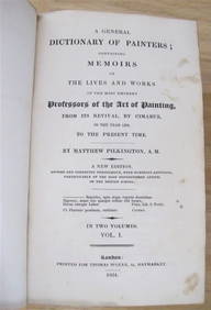
MATTHEW PILKINGTON General Dictionary Painters 2 Vol Set 1824 Calf BindingLuis Porretta Fine Arts4.3(10)See Sold PriceMar 02, 2024
Joseph Martin Kronheim Pair Early Color Glamor Prints c1850Luis Porretta Fine Arts4.3(10)See Sold PriceMar 02, 2024