SoldTwo John Speed Maps of Britainetching with hand coloring, both from Bassett & Chiswell edition of [Theatre of Empire of Great Britain]; [Devonshire with Excester Described...] and [Glocestershire...], etching with handcoloring; frSee Sold Price
SoldTwo Early Framed Engraved MapsA lot of two early hand-colored engraved maps to include a W. J. Bleau map of Amsterdam, ca. 1634-1635, "Sabaudia Ducatus Savoye", together with a John Speed map of Britain, ca. 1611-1614, "DevonshireSee Sold Price
SoldSpeed (John) - Britain As It Was Devided in the Tyme ofstrapwork title cartouche, and two panels of 14 vignettes of Saxon Kings including Ethelbert, Edwin and Ethelwolf, engraved map with hand-colouring, 385 x 510mm., woodcut initial verso by William HallSee Sold Price
SoldTWO JOHN SPEED MAPS OF THE COUNTY OF CUMBERLAND AND WESTMORLANDTWO JOHN SPEED MAPS OF THE COUNTY OF CUMBERLAND AND WESTMORLAND in monochrome colours and featuring the city of Carlisle and town of Kendale, mounted and in modern glazed narrow ebonized frames (41cmSee Sold Price
SoldJohn Speed Map of Great BritainEnglish, 17th century, "The Kingdome [sic] of Great Britaine and Ireland," by John Speed, engraved by J. Hondius, printed by Sudbury and Humble, London, 1610, with elaborate cartouches and insets of LSee Sold Price
SoldJohn Speed English 1552-1629) Antique Map Of BritainFramed antique map of Britain, drawn by John Speed, circa 1616. John Speed was an English cartographer and historian. He is, alongside Christopher Saxton, one of the best known English mapmakers of thSee Sold Price
SoldHand colored engraved map, John Speed, BritainFramed hand colored copper engraved map, ""Britain as it was Divided in the time of the English Saxons,"" by John Speed (British,1552-1629), image: 15""h x 20""w, overall: 26""h x 31""wSee Sold Price
SoldJohn Speed (1552-1629) - Coloured engraving - Map of “John Speed (1552-1629) - Coloured engraving - Map of “Britain as it was devided.....”, 15ins x 19.75ins, published by Thomas Bassett & Richard Chiswell, in gilt moulded frame and glazedSee Sold Price
SoldJohn Speede Map of Britain & 2 other mapsJohn Speede engraving Two Maps of Britain as divided at the time of the Saxons 15 x 20in. New Mappe of the Romane Empire, 15 x 20in and A New Map of Asia, 19 x 22in.See Sold Price
John Speed (England, 1552-1629), two hand-colored mapsJohn Speed (England, 1552-1629), two hand-colored maps on paper: one of Northumberland with town planning, royal arms, and Roman sculptures, plate mark visible on top edge; the other a map of ShropshiSee Sold Price
Sold[MAPS -- WORLD AND UNITED STATES]. Two maps,[MAPS -- WORLD AND UNITED STATES]. Two maps, comprising: [FACSIMILE]. SPEED, John (1552-1629). A New and Accurate Map of the World... N.p., 20th century. Printed in color. Matted and framed (not eSee Sold Price
SoldTwo framed and glazed hand coloured mapsTwo framed and glazed hand coloured maps; John Speed, detailed 'Shropshire, described the situation of Shrowsbury Shrewed, with the arm of Thos earlies and other memorable things observed', 15.25" x 2See Sold Price
Speed (John) - Britain As It Was Devided in the Tyme ofBritain As It Was Devided in the Tyme of the Englishe Saxons Especially During Their Heptarchy, with strapwork title cartouche, and two panels of 14 vignettes of Saxon Kings including Ethelbert, EdwinSee Sold Price
SoldSpeed (John) - The Kingdome of Great Britaine andmap of Britain and Ireland with part of the coast of Flanders and Holland, inset map of the Orkneys, and inset views of London and Edinburgh, ships and sea monsters, engraved with hand-colouring, 390See Sold Price
SoldSpeed (John) - The Kingdome of Great Britaine andmap of Britain and Ireland with part of the coast of Flanders and Holland, inset map of the Orkneys, and inset views of London and Edinburgh, ships and sea monsters, engraved with hand-colouring, 390See Sold Price
Sold14 Lithographic Posters and PrintsComprises: 1.) Folio of English country maps, 17" x 22 1/4" by John Speed. 2.) Five map prints, 20" x 24" each. 3.) Six vintage lithograph posters "Gov't Bonds", approx. 28" x 20" each. 4.) Two smalleSee Sold Price
SoldBritain as it was Devided in the Tyme of the EnglAuthor: Speed, John Copper-engraved map, hand-colored; flanked by figures of 14 kings (7 per side). Speeds map of early Britain, with the notable feature of depictions of 14 kings from the 6th and 7thSee Sold Price
SoldSpeed (John) Britain as it was Devided in the tymeSpeed (John) Britain as it was Devided in the tyme of the Englishe Saxons,map of Great Britain, strapwork cartouche containing title, inset coats of arms and 2 panels depicting Saxon leaders sSee Sold Price
SoldJohn Speed's Celebrated 17th Century Map of theun-colored copperplate engraving, A New Description of Carolina (London: Thomas Basset and Richard Chiswell,1676), engraved by Francis Lamb, from The Theatre of the Empire of Great Britain, depictingSee Sold Price
Sold2 Maps. Oxfordshire and Scotia Regnum.[Great Britain] 2 Maps. Hole, William. "Scotia Regnum." c. 1610. Engraved map. Hand colored. Image: 12 1/4" x 10 1/4". Framed: 19 1/2" x 17 1/2". ++ Speed, John. "Oxfordshire described with ye Citie aSee Sold Price
SoldProvince of MounsterJohn Speed (1552-1629). Engraved map. London: 1610 (1676). 17 1/4 x 22 inches. The map is adorned with two very fine town plans of the two largest and most prominent towns in the province: Cork and LiSee Sold Price
SoldJohn Speed (1551/52 - 1629), by, two-page map,John Speed (1551/52 - 1629), by, two-page map, Darbieshire (sic, Derbyshire), Alphabetical Table and Description to verso, [S]old in popes head (sic) Alley by John Sudbury and G. Humble, [London 1627]See Sold Price
SoldJohn Speed (1551/52 - 1629), by, two-fold map,John Speed (1551/52 - 1629), by, two-fold map, Cumberland and the Ancient Citie Carlile (sic, Carlisle) Described with Many Memorable Antiquities Therein Found Observed, English text to verso, [Sold]See Sold Price
SoldSenex (John) - A New Map of Great Britain,with inset map of the Orkney and Shetland Islands, and decorative title and dedication cartouches, engraved map with original hand-colouring, 650 x 960mm., on two sheets, joined, a few repairs to horiSee Sold Price
17TH C. MAP OF THE BERKSHIRES BY JOHN SPEED, FRAMEDThomaston Place Auction Galleries4.4(393)See Sold PriceFeb 24, 2024
General Books - Nicolson - The Counties of Britain - A Tudor Atlas by John SpeedTimeLine Auctions Ltd.4.6(183)See Sold PriceMar 08, 2024
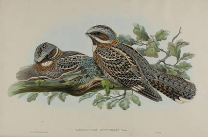
John Gould & H.C. Richter Hand Colored Bird Lithograph Caprimulgus RuficollisGlobal Auctions Company4.3(36)See Sold PriceMar 03, 2024
Hand Colored Map of the city of Amsterdam 1720Global Auctions Company4.3(36)See Sold PriceMar 03, 2024
Map: An engraved and hand coloured map titled The Countie of Nottingham described The Shire TownesClaydon Auctioneers Ltd4.3(125)See Sold PriceFeb 26, 2024
1704 DESCRIPTION OF ALL THE SEATS OF THE PRESENT WARS OF EUROPE antique w/ MAPSJasper524.5(9.9k)See Sold PriceFeb 27, 2024
Great Britain. Queen Caroline (wife of George II) AR Coronation Medal.Fellows4.3(159)See Sold PriceFeb 29, 2024


![[MAPS -- WORLD AND UNITED STATES]. Two maps, (1 of 1)](https://p1.liveauctioneers.com/197/161882/81723397_1_x.jpg?height=282&quality=70&version=1581711364)