SoldThree maps by Emanuel Bowen framed togetherTitle: Three maps by Emanuel Bowen framed together Author: Bowen, Emanuel Description: Includes: An Accurate Map of North America, Drawn from the Best Modern Maps and Charts and Regulated by Astron'lSee Sold Price
SoldThree maps by Emanuel Bowen framed togetherTitle: Three maps by Emanuel Bowen framed together Author: Bowen, Emanuel Description: Includes: An Accurate Map of Europe Drawn from the Best Modern Maps & Charts and Regulated by Astron.l Observat'nSee Sold Price
SoldBOWEN (EMANUEL), CHESHIRE DIVIDED INTO ITS HUNDREDS,BOWEN (EMANUEL), CHESHIRE DIVIDED INTO ITS HUNDREDS, c.1756, hand-coloured engraved half sheet map, framed; together with ANOTHER HAND-COLOURED ENGRAVED MAP, BRITANNIA ROMANA. (2)See Sold Price
SoldTHREE FRAMED MAP ENGRAVINGS.THREE FRAMED MAP ENGRAVINGS. Together with an off-set mechanical lithograph depicting Buck's County, Pennsylvania. Engraved maps consist of one depicting Delaware, Montgomery, and Bucks counties, PennSee Sold Price
SoldFOUR FRAMED ETCHINGS FROM JAMES BEVERALL'S 'LE GRANDFOUR FRAMED ETCHINGS FROM JAMES BEVERALL'S 'LE GRAND BRETAGNE & DE L'IRLANDE'. Hand colored. Together with three framed maps comprising one hand colored etching depicting Tartaire (Russia), (printed iSee Sold Price
18th century hand coloured map of England and Wales by18th century hand coloured map of England and Wales by Emanuel Bowen, framed, 64.5cm x 54cmSee Sold Price
SoldKNYFF AND KIP ENGRAVING OF LITTLE COMPTON.KNYFF AND KIP ENGRAVING OF LITTLE COMPTON. Together with three framed map engravings: Chart of the Morhiban, Gulf of Vanes after Jeffreys (Sight: 8.5" x 11"), a view of Deventer (Sight: 10" x 13"), anSee Sold Price
SoldGrp: 10 Maps of Africa 17th-19th c.Ten maps of Africa by cartographers including Pierre Duval (1618–1683), F. Von. Stulpnagel, Emanuel Bowen (1693-1767), and Abraham Ortelius (1527-1598). Includes three maps of Morocco and thSee Sold Price
3 MAPS, FALKLAND ISLANDS & SOUTH AMERICAGroup of three maps of South America with the Falkland Islands comprising Emanuel Bowen (English 1694-1767), "New and Accurate Map of Chili, Terra Magellanica, Terra del Fuego &c.", circa 1774; blackSee Sold Price
Fisherman's map of salmon pools on the river Dee by Maude Parker 1931 together with three framedFisherman's map of salmon pools on the river Dee by Maude Parker 1931 together with three framed fisherman's maps, the largest of the three framed 99.5cm 24cmSee Sold Price
Sold[United States/West Indies Maps] Three good maps[United States/West Indies Maps] Three good maps including: @A New and Accurate Chart of the West Indies with the Adjacent Coasts of North and South America@, by Emanuel Bowen, London, c. 1744, ornameSee Sold Price
SoldGroup of Three Antique Maps, consisting of "A NewGroup of Three Antique Maps, consisting of "A New Accurate Map of Scotland and North Britain," engraving by Emanuel Bowen (1694-1767); "Mexico or New Spain," engraving by Mathew Carey (1780-1839); andSee Sold Price
SoldMap of Emanuel Bowen Mid 18th C "An Accurate Mapof Barbadoes", handcoloured etching, framed, 34cm x 41cmSee Sold Price
Sold3 Early Maps Gloucestershire England3 Early Maps Gloucestershire England. First- Robert Morden 1695 Framed Map 18" x 15". Second- 1785 Issue map by Emanuel Bowen 17 1/2" x 14" in very good condition. Third- 1770 map of Somerset Shire haSee Sold Price
E. Carrott (20th Century) Three Watercolors.E. Carrott (20th Century) Three Watercolors. Two are framed together, while one is framed alone. All three depict harbor scenes. Together with three reproduction maps of Michigan: Roaring Brook, LittlSee Sold Price
England.- Bowen (Emanuel) An Accurate Map of SussexEngland.- Bowen (Emanuel) An Accurate Map of Sussex ...' Northhampton Shire ...; Nottingham Shire ..., three county maps, engravings, each 570 x 750 mm. (22 1/2 x 29 1/ 2 in ), or the reverse, marginaSee Sold Price
SoldEmanuel Bowen Map of Mexico and Central Americacopperplate engraving with outline color, A New & Accurate Map of Mexico or New Spain together with California New Mexico &c., from A Complete System of Geography (London, 1747), with inset map of theSee Sold Price
SoldAN 18TH CENTURY FRAMED MAP OF SURREY by Emanuel Bowen,AN 18TH CENTURY FRAMED MAP OF SURREY by Emanuel Bowen, printed for Carington Bowles 1st June 1777. 1ft 9ins x 1ft 4.5ins.See Sold Price
John Owen y Emanuel Bowen - Map of Durham (1720)Framed. Sizes with frame: 30 x 24 cm Map measurements: 19 x 12 cm Beautiful map of Durham ( United Kingdom ) from the 18th century - year 1720 - Colored from that time. With the antique dealer's stampSee Sold Price
John Owen y Emanuel Bowen - Map of Durham (1720)Framed. Sizes with frame: 30 x 24 cm Map measurements: 19 x 12 cm Beautiful map of Durham ( United Kingdom ) from the 18th century - year 1720 - Colored from that time. With the antique dealer's stampSee Sold Price
Sold18th c. Hand Colored Map of Bermuda and St Kittsan original map by cartographer Emanuel Bowen 1694?-1767, detailed maps of Bermuda and St. Kitts c. 1744, with annotations noting shipwrecks, whaling, fortifications, churches etc. framed 17x19 LitchfSee Sold Price
Sold1764 MapFramed copy of Emanuel Bowen's Western Atlantic Ocean map dated 1764. Measures 18"x 15"See Sold Price
SoldNan Parker, oil on canvas, river scene with moored boatNan Parker, oil on canvas, river scene with moored boat and distant church, together with a gilt framed map of Surrey and three other large framed printsSee Sold Price
Sold[MAP - WORLD]. BOWEN, Emanuel (d. 1767). Niewe en[MAP - WORLD]. BOWEN, Emanuel (d. 1767). Niewe en Naukeurige Kaart des geheelen Aardbodems' [Amsterdam,] 1744. Engraved map hand-colored in outline, visible area 515 x 610 mm, matted and framed (unexaSee Sold Price
A Continental Framed Needelpoint of Three Maidens A Framed Handpainted Textile Pattern, TogetherNazmiyal Auctions4.4(34)See Sold PriceFeb 26, 2024
1885 CIVIL WAR 1ed Famous Memoirs US Grant Sheridan Sherman 6v RARE LOT MapsSchilb Antiquarian Rare Books4.8(421)See Sold PriceMar 10, 2024
[ARCTIC]. BOWEN, Emanuel. A New & Accurate Map of the North...Potter & Potter Auctions4.6(539)See Sold PriceMar 07, 2024
Vintage Chinese Porcelain Items, Two Total, Table Screen and Figurines on StandNorthgate Gallery, Inc.4.5(34)See Sold PriceMar 02, 2024
Three silver buttons with Art Nouveau floral detail, hallmarked Birmingham 1904, maker Adie LovekinClaydon Auctioneers Ltd4.3(125)See Sold PriceFeb 25, 2024
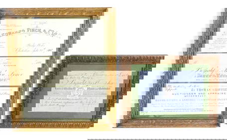
Four 19thC Welsh receipts / bill heads / compliment slips relating to Edward Finch & Co. Ltd.Claydon Auctioneers Ltd4.3(125)See Sold PriceFeb 26, 2024
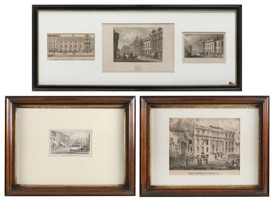
FIVE ARCHITECTURAL PRINTS OF HISTORIC NEW YORK AND LONDON BUILDINGS 19th CenturyEldred's4.7(409)See Sold PriceMar 07, 2024
Alfred Salzman, Etc. JNF Tin Tzedakah Boxes, 3Auctions at Showplace4.5(726)See Sold PriceApr 07, 2024
Late 18th century map of England and Wales sampler and two printsFellows4.3(159)See Sold PriceMar 05, 2024
Framed Vintage Map Of Le Port Au Prince In The Island Of Santo DomingoRapid Estate Liquidators and Auction Gallery4.5(1.1k)See Sold PriceMar 01, 2024
Disney Magic Mediterranean Cruise 2007 Map W CoinsRapid Estate Liquidators and Auction Gallery4.5(1.1k)See Sold PriceMar 01, 2024


![[United States/West Indies Maps] Three good maps (1 of 3)](https://p1.liveauctioneers.com/268/2586/1120904_1_x.jpg?height=282&quality=70)


![[ARCTIC]. BOWEN, Emanuel. A New & Accurate Map of the North... (1 of 1)](https://p1.liveauctioneers.com/928/318880/171360917_1_x.jpg?height=282&quality=70&version=1707501302)


![[MAP - WORLD]. BOWEN, Emanuel (d. 1767). Niewe en (1 of 1)](https://p1.liveauctioneers.com/197/161882/81723385_1_x.jpg?height=282&quality=70&version=1581711364)