SoldTHREE ANTIQUE ENGRAVED EUROPEAN MAPStwo hand-colored with one titled Ducatus Valois detailing the Valois region of France, another titled Comitatus Tirolen Sis detailing the general areas of southern Germany, northern Italy and parts ofSee Sold Price
SoldThree European Hand-Colored MapsThree Antique European Hand-Colored Maps , 18th c., incl.: "The Countie and Citie of Lyncolne Described with the Armes...", 15 in. x 20 in.; "Istria olim Iapidia", 15 in. x 19 1/2 in.; and "PrincipatuSee Sold Price
SoldThree Antique Hand Colored MapsA grouping of three antique hand-colored engraved maps to include a 1642 map of America, a 1794 Laurie and Whittle plan of a Puerto Cavello, and a Laurie and Whittle plan of the Road and Town of La GuSee Sold Price
Sold3 ANTIQUE HAND COLORED COPPER ENGRAVED MAPSA collection of three antique hand colored copper engraved maps. Ht: 20.75" Wd: 25.75" (largest, framed)See Sold Price
Sold4pc New England ANTIQUE ENGRAVED MAPS 1886-1891Details: This lot consists of the antique lithographed maps shown in the corresponding image(s).This lot consists of a group of four maps of New England. Three are from Rand, McNally: "New Hampshire"See Sold Price
SoldAntique 1800's European SWITZERLAND Engraved MapAntique 1800's European SWITZERLAND Engraved Map Colored. Unframed, Paper Size: 11" x 9" MINT ConditionSee Sold Price
SoldThree Antique Platinum BandsThree Antique Platinum Bandsthe first set to the front with old European cut diamond accents in a platinum mount with engraved detailing, stamped PM (ring size 6); the second with bezel set Marquise cSee Sold Price
SoldTallis / Rapkin: Antique Map, Plan of Brighton, 1850Title/Content of Map: 'Brighton' Decorative antique town plan Date Printed: c1850 Image Size: Approx 36.5 x 26.5cm, 14.5 x 10.25 inches (Large) Type: Antique engraved map Condition: Good; suitable forSee Sold Price
SoldThree Antique 18KT White Gold and Diamond RingsThree Antique 18KT White Gold and Diamond Ringsthe first set with an old European cut diamond weighing approximately .25 carat (K color, VS2 clarity) and mount with engraved detailing stamped 18K (rinSee Sold Price
SoldSDUK: Three Antique Maps of Turkey in Europe, 1830Map: Turkey I, II and III Cartographer: Baldwin & Cradock, Society for the Diffusion of Useful Knowledge Place & Date: London / 1830/1852 Size: 15" x 12 1/2" (the largest of the three maps) Condition:See Sold Price
SoldAn Antique Engraved and Enameled Three-Diamond Ring An antique gold ring with an engraved and enameled shank and under gallery containing three SI2-I1, G-H color European cut diamonds set in buttercup heads weighing approximately .60 carats total weighSee Sold Price
Tassin: Antique Map of Calais, France, 1636Title/Content of Map: Fine 17th century antique map of Calais, France Date Printed: 1636 Cartographer: Tassin, Christophe Nicholas Size (inches): 6 x 4 Full contemporary hand color Antique engraved viSee Sold Price
Tallis / Rapkin: Antique Map of of Brighton, 1850Title/Content of Map: 'Brighton' Decorative antique town plan Date Printed: c1850 Image Size: Approx 36.5 x 26.5cm, 14.5 x 10.25 inches (Large) Type: Antique engraved map Condition: Good; suitable forSee Sold Price
Perrot: Antique Rare Map of Corsica, 1823Title/Content of Map: 'Corse' Corsica département. Scarce antique map/carte Date Printed: 1823 Image Size: Approx 13.5 x 8.5cm, 5.25 x 3.25 inches (Small) Type: Antique engraved map with original outSee Sold Price
SoldANTIQUE MAPSANTIQUE MAPS Lot of three antique maps, all by mapmaker Jedidiah Morse, copperplate-engraved by Amos Doolittle and published by [Isaiah] Thomas & Andrews, Boston, 1796. The maps, each about 10" x 8 1/See Sold Price
Three antique Imperial Russian silver vodka cups andThree antique Imperial Russian silver vodka cups and tray.Each cup engraved with a sailing ship and the tray with a matching boarder.Stamped USSR.Tray measures 6 3/8" across. Cups 1 3/4" high.See Sold Price
SoldThree Antique European Naturalist Hand-Colored Printsincluding two hand-colored engravings from The Naturalist's Library, mid 19th century, published by Sir William Jardine, engraved by Wm. Lizars, "The Angel Fish" (plate 29) and "Old British Torpedo" (See Sold Price
Tallis/Rapkin: Antique Town Plan of Brighton, 1850Title/Content of Map: 'Brighton', Decorative antique town plan Date Printed: c1850 Image Size: Approx 36.5 x 26.5cm, 14.5 x 10.25 inches (Large) Type: Antique engraved map Condition: Good; suitable foSee Sold Price
Sold3 Bellin Maps, incl. Louisiana, Florida, 1760sThree (3) Jacques-Nicolas Bellin (1703-1772) copper plate engraved maps with hand coloring and decorative cartouches on laid paper, all from "Le Petit Atlas Maritime", 1764. 1st item: Embouchures du FSee Sold Price
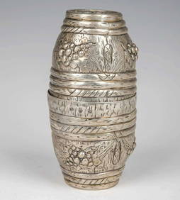
SoldAntique 830 Silver Lion Footed Engraved 5.75" VaseVintage European Engraved Vase. Crafted of 830 Silver. Lion Feet with Ornate Engraved Decoration. Features three "Lion with Battle Axe" Pendants on Sides. Gilt Interior. Probably made for the PersianSee Sold Price
SoldSDUK: Antique Map of Portugal, 1845TITLE/CONTENT OF MAP: 'PORTUGAL' Provinces. Algarve Alentejo Estremadura Beira etc. DATE PRINTED: 1845 IMAGE SIZE: Approx 37.5 x 27.5cm, 14.75 x 10.75 inches (Large) TYPE: Antique steel engraved map wSee Sold Price
SoldSDUK: Antique City Map Plan of Amsterdam, 1847Title/Content of Map: 'AMSTERDAM.; inset environs of Amsterdam' Date Printed: 1847 Image Size: Approx 34.5 x 40.5cm, 13.5 x 15.75 inches (Large) Type: Antique steel engraved map with original outlineSee Sold Price
SoldSDUK: Antique Map of Paris Environs, 1847Title/Content of Map: 'THE ENVIRONS OF PARIS' Fortifications Versailles Vincennes St Denis Date Printed: 1847 Image Size: Approx 33.0 x 39.5cm, 12.75 x 15.5 inches (Large) Type: Antique steel engravedSee Sold Price
SDUK: Antique Map of Italy, 1845Title/Content of Map: 'ITALY IV, General map including Sicily, Malta, Sardinia, and Corsica' Date Printed: 1845 Image Size: Approx 40.5 x 34.5cm, 16 x 13.5 inches (Large) Type: Antique steel engravedSee Sold Price
1816 MAP SOUTHERN PART OF RUSSIA or MUSCOVY in EUROPE copper engraving ANTIQUEJasper524.5(9.8k)See Sold PriceFeb 27, 2024
NORTHERN AFRICA. Morocco Tunisia Algeria. Caravan routes. RAPKIN/TALLIS 1851 mapJasper524.5(9.8k)See Sold PriceFeb 28, 2024
West Africa by Arrowsmith & Lewis 1812 old antique vintage map plan chartJasper524.5(9.8k)See Sold PriceFeb 28, 2024
NORTH AFRICA OF BABRBARY V Parts of Tripoli & Egypt. Libya Tribes. SDUK 1846 mapJasper524.5(9.8k)See Sold PriceFeb 28, 2024
COLONIES FRANÇAISES AFRIQUE. Africa Sénégambie Madagascar. LEVASSEUR 1856 mapJasper524.5(9.8k)See Sold PriceFeb 28, 2024
AFRIQUE. Africa. Decorative antique map/carte by Victor LEVASSEUR 1856 oldJasper524.5(9.8k)See Sold PriceFeb 28, 2024
Africa. Mauritius, Bourbon (Reunion) & Natal by Edward Weller 1860 old mapJasper524.5(9.8k)See Sold PriceFeb 28, 2024
NIGERIA explorers' routes. Lander Clapperton Oudney Denham Allen. SDUK 1874 mapJasper524.5(9.8k)See Sold PriceFeb 28, 2024
NORTH AFRICA OF BABRBARY V Parts of Tripoli & Egypt. Libya Tribes. SDUK 1851 mapJasper524.5(9.8k)See Sold PriceFeb 28, 2024
Afrique…Nord-Ouest' & 'Inde' by Meissas. N Africa India Singapore 1861 old mapJasper524.5(9.8k)See Sold PriceFeb 28, 2024
ANCIENT NORTH AFRICA. Greek colonies. "La Libye, L'Egypte…". TARDIEU 1830 mapJasper524.5(9.8k)See Sold PriceFeb 28, 2024
NORTH AFRICA BARBARY. Parts of Tripoli (Libya) & Egypt. Tribes. SDUK 1848 mapJasper524.5(9.8k)See Sold PriceFeb 28, 2024
NORTHERN AFRICA. Morocco Tunisia Algeria. Caravan routes.TALLIS/RAPKIN 1851 mapJasper524.5(9.8k)See Sold PriceFeb 28, 2024
NORTHERN AFRICA. Morocco Tunisia Algeria. Caravan routes. RAPKIN/TALLIS 1851 mapJasper524.5(9.8k)See Sold PriceFeb 28, 2024
Africa by Arrowsmith & Lewis 1812 old antique vintage map plan chartJasper524.5(9.8k)See Sold PriceFeb 28, 2024
ANTIQUE GEOMORPHOLOGY: 1782 POMPONII MELA DE SITU ORBIS ARMORIAL VELLUM BINDINGNY Elizabeth 4.3(85)See Sold PriceMar 03, 2024
1675: ANTIQUE ILLUSTRATED JULIUS CAESAR MAPS OF ROMAN HISTORYNY Elizabeth 4.3(85)See Sold PriceMar 03, 2024