SoldThomas Kitchen, antique map of Poland showing theThomas Kitchen, antique map of Poland showing the claims of Austria, Russia and Prussia, 8ins x 11ins, another hand coloured map of Afghanistan and another uncoloured map of Poland, Lithuania and PrusSee Sold Price
SoldKitchen: Antique Map of Africa, 1782Map: Africa, Agreeable to the Most Approved Maps and Charts, by Mr. Kitchen. Engraved for Millar's New Complete & Universal System of Geography Publication Date: 1782 Cartographer: Thomas Kitchen/Geo.See Sold Price
Kitchen: Antique Map of Countries On the South SeaTitle/Content of Map: Map of the Countries On the South Sea, from Panama to Guayquil. Date Printed: 1777 Cartographer: KITCHEN THOM. SR. Size: 14.5X9.5 Topographically detailed showing mountains, riveSee Sold Price
SoldKitchin, Thomas 1785 Antique Map of AsiaCopper Engraved Map Published 1783-85, London for "A New Geographical, Historical and Commercial Grammar..." by William Guthrie. Drawn and Engraved by Thomas Kitchin (Kitchen) and John Barber. Rare, ESee Sold Price
SoldStackhouse: Antique Map of Poland, 1783Title/Content of Map: Poland by Stackhouse Date Printed: 1783 Cartographer: Thomas Stackhouse Material/Medium: Paper Size: 16" x 20" Original hand color, copperplate engraved. Published in London in 'See Sold Price
SoldKitchin, Thomas 1785 Antique Map of The East IndiesCopper Engraved Map Published 1783-85, London for "A New Geographical, Historical and Commercial Grammar..." by William Guthrie. Drawn and Engraved by Thomas Kitchin (Kitchen) and John Barber. Rare, ESee Sold Price
SoldRobinson / Dilly: Antique Map of Poland, 1785Map: Poland Date Printed: 1785 Cartographer: G. Robinson & C. Dilly Material/Medium: Paper Size: 9 3/4" x 8 1/3" Condition: Excellent Published in London. Showing the changes of Russia, Prussia, & AusSee Sold Price
Stackhouse: Antique Map of Poland & Prussia, 1783Map: Poland & Prussia Date Printed: 1783 Cartographer: Thomas Stackhouse Material/Medium: Paper Size: 20" x 16" Condition: Good. Margin cut too close on left edge of Map. Otherwise in great shape. HanSee Sold Price
Antique Map of Upper Silesia - Grodkow and Nysa - Poland - Europe - JanssoniusAttractive old coloured engraved map of Upper Silesia from J. Scultetus by J. Janssonius. Showing the area around Nysa and Grodkow. With three beautiful coloured cartouches. Johannes Janssonius also kSee Sold Price
Stackhouse: Antique Map of Dacia, 1783Title/Content of Map: Rare Map showing ancient Dacia. Today's Hungary & Balkan area Date Printed: 1783 Cartographer: Thomas Stackhouse Material/Medium: Paper Size: 16" x 20" Original hand color. CoppeSee Sold Price
SoldAN ANTIQUE MAP, "United States," BOSTON, CIRCA 1838,AN ANTIQUE MAP, "United States," BOSTON, CIRCA 1838, hand colored engraving on paper, showing Texas as an independent nation, a page fragment from an atlas, Thomas Gamaliel Bradford (1802-1887) cartogSee Sold Price
SoldNew Map of Cherokee Nation, uncut from the LondonTHE LONDON MAGAZINE OR GENTLEMAN'S MONTHLY INTELLIGENCER, published February 1760, containing the fold out map by Thomas Kitchen, "engraved from an Indian draught" and entitled A NEW MAP OF THE CHEROKSee Sold Price
Pirate treasure map and compass, Dizzy Bunny, kittPirate treasure map and compass, Dizzy Bunny, kitchen unit cooking Hot wheels mini challenge, twin-induction ’71 Corvette Grand Sport. mini golf set, Ken doll in black tux. Thomas the Train soft bloSee Sold Price
Kitchen: Antique Map of Mexico/New Spain, 1777Map: Mexico or New Spain in which the Motions of Cortes may be traced Cartographer: Kitchin Place & Date: London / 1777 / 1821 Size: 15 3/8" x 11 1/4" Condition: trimmed close to neat line; margins reSee Sold Price
Marshall: Antique Map Showing New York City in 1776Map: 1807 Marshall Map Showing New York City in 1776 -- Ile de New-York. Partie de Long-Island ou de l'Ile Longue, et Positions des Armees Americaine et Britannique, apres le Combat Livre sur HauteursSee Sold Price
Marshall: Antique Map Showing New York City in 1776Map: 1807 Marshall Map Showing New York City in 1776 -- Ile de New-York. Partie de Long-Island ou de l'Ile Longue, et Positions des Armees Americaine et Britannique, apres le Combat Livre sur HauteursSee Sold Price
Marshall: Antique Map Showing New York City in 1776Title/Content of Map: 1807 Marshall Map Showing New York City in 1776 -- Ile de New-York. Partie de Long-Island ou de l'Ile Longue, et Positions des Armees Americaine et Britannique, apres le Combat LSee Sold Price
SoldKitchen: Antique Map of Mexico or New Spain, 1777Map: Mexico or New Spain in which the Motions of Cortes may be traced Cartographer: Kitchin Place & Date: London / 1777 / 1821 Size: 15 3/8" x 11 1/4" Condition: trimmed close to neat line; margins reSee Sold Price
Marshall: Antique Map Showing New York City in 1776Title/Content of Map: 1807 Marshall Map Showing New York City in 1776 -- Ile de New-York. Partie de Long-Island ou de l'Ile Longue, et Positions des Armees Americaine et Britannique, apres le Combat LSee Sold Price
SoldMitchell, Thomas: Antique Map of Hindostan, 1854Title: Map of Hindostan by Mitchell, Thomas,DeSilver Date: 1854 Dimensions: 14 x 17 Medium: Hand Colored Lithograph Samuel Augustus Mitchell (1790-1860) was an American geographer born in ConnecticutSee Sold Price
SoldKitchen: Antique Map of Asia, 1800Map: Asia, Drawn from the Latest Astronomical Observations. Publication Date: 1800 ca. Authors: KITCHEN, T. ? Size: Quarto – 11.50 H x 8.75 W Inches Folding map from an unidentified octavo volume. FSee Sold Price
SoldMitchell, Thomas: Antique Map of Sardinia, 1851Title: Map of the Kingdom of Sardinia by Mitchell, Thomas, Cowperthwait Date: 1851 Dimensions (inches): 17 x 14 Medium: Hand Colored Lithograph Condition: Good Condition Samuel Augustus Mitchell (1790See Sold Price
Marshall: Antique Map Showing New York City in 1776Title/Content of Map: 1807 Marshall Map Showing New York City in 1776 -- Ile de New-York. Partie de Long-Island ou de l'Ile Longue, et Positions des Armees Americaine et Britannique, apres le Combat LSee Sold Price
SoldAntique map Poland MordenUnframed antique map, ''A New Mapp [sic] of the Estates of the Crown of Poland'', published by Robert Morden (British, 1668-1703), engraved by F. Lamb, sheet: 20''h x 24''wSee Sold Price
1736 LARGE MAP OF SILESIA POLAND OPPAVIENSIS antique 25 by 34 3/4"Jasper524.5(9.8k)See Sold PriceFeb 27, 2024
1736 LARGE MAP OF SILESIA POLAND KARNOVIENSIS antique 25 x 4 3/4" Duchy of KrnovJasper524.5(9.8k)See Sold PriceFeb 27, 2024
SECOND WORLD WAR AFRICA. European colonies & German mandates 1940 old mapJasper524.5(9.8k)See Sold PriceFeb 28, 2024
WEST AFRICA. Guinea. Nigeria Ghana Benin Togo Sierra Leone. MALLET 1683 mapJasper524.5(9.8k)See Sold PriceFeb 28, 2024
AFRICA. Political Map of showing International Boundaries 1936 old vintageJasper524.5(9.8k)See Sold PriceFeb 28, 2024
Central Africa. Map showing great forest traversed by Mr Stanley, 1890Jasper524.5(9.8k)See Sold PriceFeb 28, 2024
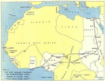
West Africa WW2 Nigeria Sudan Egypt. Takoradi air reinforcement route 1954 mapJasper524.5(9.8k)See Sold PriceFeb 28, 2024
WEST AFRICA showing early explorers' routes & Mountains of Kong. SDUK 1844 mapJasper524.5(9.8k)See Sold PriceFeb 28, 2024
Operation Torch Nov 1942-May 1943. World War 2. Western Mediterranean 1966 mapJasper524.5(9.8k)See Sold PriceFeb 28, 2024
Guthrie, William 1812 Antique Map. Spain and PortugalAlbion Auctions4.6(336)See Sold PriceMar 01, 2024
Antique Map of Poland, 1700 by Guillaume De Lisle, ParisAntiques Online Auctions4.6(407)See Sold PriceMar 14, 2024