SoldThe Empire of China, map, Lon: Sayer, 1790[China]. M. Bowen after D'Anville. The Empire Of China, With Its Principal Divisions; Drawn from the Surveys made by the Jesuits: with Improvements and Additions, from the Maps of Monsr. D'Anville. DoSee Sold Price
Sayer Map of Russian Empire, 1790Unknown. European Part of the Russian Empire. Engraved map. Robert Sayer, 1788-1790. 42 ½" x 52 ½" sheet. from the maps published by the Imperial Academy at St. Petersburg, with the new provinceSee Sold Price
Rochette Map of Germany, 1790De La Rochette, Louis Stanislas d'Arcy (1731-1802). Map of the Empire of Germany. Engraved Map with full color. Robert Sayer, 1790. 42½" x 45" sheet. Including all the states comprehended under thaSee Sold Price
SoldAsian and European Russia. Lon: Sayer, c.1790[Russia]. The European Part [& Asiatic Part] Of the Russian Empire From the Maps Published by the Imperial Academy of St. Petersburg With the Provinces on the Black Sea [&] With the New Discoveries ofSee Sold Price
SoldSamuel Dunn. China. 1774.[China]. Samuel Dunn. China, Divided into its Great Provinces, and the Isles of Japan. Double-page engraved map, 12 7/8 x 18 1/8 in. Lon: Robert Sayer, 1774 [1774-96]. Contemporary outline color. FainSee Sold Price
SoldA Late 18th Century Map of The European Part of thelate 18th Century map of "The European Part of the Russian Empire, The Asiatic Part of the Russian Empire", publ Robert Sayer, London 1st May 1790; engraved map with hand-colouring, from the maps publSee Sold Price
SoldA Late 18th Century Map of The European Part of thelate 18th Century map of "The European Part of the Russian Empire, The Asiatic Part of the Russian Empire", publ Robert Sayer, London 1st May 1790; engraved map with hand-colouring, from the maps publSee Sold Price
SoldWinterbotham. An Historical... Chinese Empire...[Asia/China] W. Winterbotham. An Historical, Geographical, And Philosophical View Of The Chinese Empire… Lon: the Editor/ J. Ridgway/ W. Button, nd, stated Second Edition, a reissue of the sheets ofSee Sold Price
SoldThe Empire of China Map 1794The Empire of China with its Principal Divisions, 1794 Hand colored map Plate: 19.50 x 25.75 inches/ 49.5 x 65.4 centimeters Published by Laurie and Whittle London 1794 Frame: 22.25 x 30.50 inches/ 56See Sold Price
SoldLaurie & Whittle London 18th Century ''The Empire ofLaurie & Whittle London 18th Century ''The Empire of China'' Map 20''x26'' Image. English hand tinted map of China dated 1794. Wah Cheong, Hong Kong framing label on verso. Framed 21.5''x27.5''. ToninSee Sold Price
Jeffery's Map of East Indies, 1790Jefferys, Thomas (1719-1771). East Indies With The Roads. Engraved map. Robert Sayer, 1790. 42" x 54 ½" sheet. By Thomas Jefferys, geographer to the King. MDCCLXVIII. The Second edition. To the dirSee Sold Price
SoldEmpire of China bookDescription of the Empire of China, maps and history. Title page is dated 1741. Book measures 16 inches x 10.5 inches x 2 inches thick.See Sold Price
SoldRobert Sayer Map, 1790Robert Sayer, "A New General Chart of the West Indies from the Latest Marine Journals and Surveys...", London, 1790, hand-colored in outline, printed on two separate sheets, very detailed large-formatSee Sold Price
SoldRobert Sayer Map, 1790Robert Sayer, "A New General Chart of the West Indies from the Latest Marine Journals and Surveys...", London, 1790, hand-colored in outline, printed on two separate sheets, very detailed large-formatSee Sold Price
ASIA Hindoostan Arabia Persia Tataria Birman Empire China. ARROWSMITH 1828 mapTITLE/CONTENT OF MAP: 'Asia' DATE PRINTED: 1828 IMAGE SIZE: Approx 26.0 x 31.5cm, 10.25 x 12.5 inches (Large) TYPE: Antique copperplate map with original outline colour CONDITION: Good; suitable for fSee Sold Price
Map China Empire 1820 coloured by hand with aquarello,Nice map of China of 1820 circa coloured by hand with aquarello painting. Author: Batelli e Fanfani Date: 1820 circa Technique: Copper etching Leaf Dimension: 44x27,5 cm (17.3x10.8 inches) Engraving DSee Sold Price
ASIA Hindoostan Arabia Persia Tataria Birman Empire China. ARROWSMITH 1828 mapTITLE/CONTENT OF MAP: 'Asia' DATE PRINTED: 1828 IMAGE SIZE: Approx 26.0 x 31.5cm, 10.25 x 12.5 inches (Large) TYPE: Antique copperplate map with original outline colour CONDITION: Good; suitable for fSee Sold Price
SoldD'anville Map of Russia, 1780D'Anville, Jean Baptiste Bourguignon (1697-1782). Whole Russian Empire. Engraved map. Robert Sayer, 1780. 18 ½" x 50 ¼" sheet. Polar projected double-sheet map based on D'Anville. Map 20 from SaSee Sold Price
L'Empire de la Chine'. The Empire of China. BELLIN /TITLE/CONTENT OF MAP: 'L'Empire de la Chine [The Empire of China]' This map is folding hence the centrefold line may show on the image below DATE PRINTED: 1749 IMAGE SIZE: Approx 29.5 x 40.0cm, 11.75See Sold Price
SoldMap of China Empire and Japan Coloured By Hand 1832Map of China Empire and Japan Coloured By Hand 1832 Lapie Etching On Steel 1832 Lapie M. (Pierre) (1779-1850) etching on steel Leaf Dimension: 66x52 cm (25.98x20.47 inches) Engraving Dimension: 60x45See Sold Price
SoldMap of China Empire and Japan 1875 Brue Etching OnMap of China Empire and Japan 1875 Brue Etching On Steel 1875 Brue Adrien Hubert (1786-1832) etching on steel Leaf Dimension: 62x48 cm (24.41x18.9 inches) Engraving Dimension: 54x39 cm (21.26x15.35 inSee Sold Price
SoldJohnston: Antique Map of the Chinese Empire, 1900Title/Content of Map: 'China' CHINESE EMPIRE. China East Asia Tibet Mongolia East Turkestan Korea Date Printed: 1900 Image Size: Approx 20.5 x 27.0cm, 8 x 10.5 inches (Medium) Type: Antique colour mapSee Sold Price
Sold1904 Smith Map of China -- Chinese EmpireTitle/Content of Map: 1904 Smith Map of China -- Chinese Empire Date: 1904, New York Cartographer: B Smith Size: 10.4 x 15 in. This is a very detailed map of China, with the color coded dependencies sSee Sold Price
SDUK: Antique Map of China / Birman Empire, 1834Map: China and the Birman Empire Cartographer: Baldwin & Cradock, Society for the Diffusion of Useful Knowledge Place & Date: London / 1834 Size: 15" x 12 1/2" Condition: b&w; light overall age toningSee Sold Price
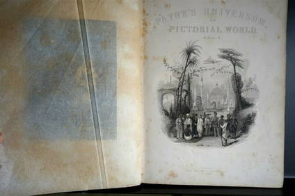
PAYNES UNIVERSUM ca1850 Calf 1st ed Travel 65 X Engravings China etc.Luis Porretta Fine Arts4.3(10)See Sold PriceMar 02, 2024
18 Booklets Collection - War Graves of Palestine - WWILevy Auction House4.4(11)See Sold PriceFeb 27, 2024
[ARCTIC]. BOWEN, Emanuel. A New & Accurate Map of the North...Potter & Potter Auctions4.6(538)See Sold PriceMar 07, 2024
1816 MAP SOUTHERN PART OF RUSSIA or MUSCOVY in EUROPE copper engraving ANTIQUEJasper524.5(9.7k)See Sold PriceFeb 27, 2024
1816 MAP NORTHERN PART OF RUSSIA or MUSCOVY in EUROPE copper engraving ANTIQUEJasper524.5(9.7k)See Sold PriceFeb 27, 2024
New and Correct Map of North America With the West India Islands,Jasper524.5(9.7k)See Sold PriceFeb 27, 2024
Perry, Matthew C. 1856 Large Map. Shah Bay, Lew Chew I. JapanAlbion Auctions4.7(335)See Sold PriceMar 01, 2024
ANTIQUE ILLUSTRATED HANDBOOK OF GEOGRAPHY AND TRAVEL IN ASIA, VOLUME 2, 1896NY Elizabeth 4.3(83)See Sold PriceMar 03, 2024
51 pcs Vintage China Tea Set Assortment. Winterling Bavaria Germany Patterns 24 & 30. See pics.Crawford Family Auctions LLC4.5(100)See Sold PriceMay 25, 2024


![[ARCTIC]. BOWEN, Emanuel. A New & Accurate Map of the North... (1 of 1)](https://p1.liveauctioneers.com/928/318880/171360917_1_x.jpg?height=282&quality=70&version=1707501302)