MATTHEWS c1856 Map Of Upper Canada Ontario Indian Land Agency Divisions Scarce!Luis Porretta Fine Arts4.3(10)See Sold PriceMar 02, 2024
DEVINE c1856 Dr Salters Map Of Lake Huron Ontario Indian Lands etc. No. 7 ScarceLuis Porretta Fine Arts4.3(10)See Sold PriceMar 02, 2024
DUNLEVIE c1856 Map Counties Of Gaspe & Bonaventure Quebec Canada SCARCE! #1Luis Porretta Fine Arts4.3(10)See Sold PriceMar 02, 2024
DUNLEVIE c1856 Map Counties Of Gaspe & Bonaventure Quebec Canada SCARCE! #2Luis Porretta Fine Arts4.3(10)See Sold PriceMar 02, 2024
Map UNITED COUNTIES LEEDS & GRENVILLE by Walling 1861 Rare Canada Map 5ft x 5ftLuis Porretta Fine Arts4.3(10)See Sold PriceMar 02, 2024
Ambroise TARDIEU c1822 Map Venice Napoleon Italian Campaign 17" x 11"Luis Porretta Fine Arts4.3(10)See Sold PriceMar 02, 2024
Tallis / Rapkin: Antique Map of West Canada, 1849Title/Content of Map: 'West Canada' The map shows the eastern part of modern Ontario, divided into districts/counties. Part of the map is shown as "Indian territory", with "Indian traders" marked. VigSee Sold Price
SoldTallis/Rapkin: Antique Map of West Canada, 1849TITLE/CONTENT OF MAP: 'West Canada' The map shows the eastern part of modern Ontario, divided into districts/counties. Part of the map is shown as "Indian territory", with "Indian traders" marked. VigSee Sold Price
SoldBritish America. Shows Hudson's Bay Company Forts MapBritish America. Shows Hudson's Bay Company Forts.canada Tallis/rapkin, 1849 Map. Approx 27.0 x 33.5cm, 10.5 x 13.25 inches (Large); Please note that this is a folding map. Antique engraved map by J RSee Sold Price
SoldJohn Rapkin: Map of West Canada, 1851Map: West Canada Cartographer: John Rapkin Illustrator: H. Warren, H. Publisher: John Tallis & Company Published: London and New York, 1851 Size: 10 x 13 inches Extremely clean, authentic antique mapSee Sold Price
Sold1849 Map of East Canada & New BrunswickOriginal 1849 Antique engraved map by J Rapkin, published by John Tallis. Original outline hand color, decorative border & inset vignette views of North American Indians, bison & ships in the whalingSee Sold Price
1849 Map of East Canada & New BrunswickOriginal 1849 Antique engraved map by J Rapkin, published by John Tallis. Original outline hand color, decorative border & inset vignette views of North American Indians, bison & ships in the whalingSee Sold Price
Sold1849 Map of East Canada & New BrunswickOriginal 1849 Antique engraved map by J Rapkin, published by John Tallis. Original outline hand color, decorative border & inset vignette views of North American Indians, bison & ships in theSee Sold Price
Sold1849 Map of East Canada & New BrunswickOriginal 1849 Antique engraved map by J Rapkin, published by John Tallis. Original outline hand color, decorative border & inset vignette views of North American Indians, bison & ships in the whalingSee Sold Price
Sold1849 Map of East Canada & New BrunswickOriginal 1849 Antique engraved map by J Rapkin, published by John Tallis. Original outline hand color, decorative border & inset vignette views of North American Indians, bison & ships in theSee Sold Price
1849 Map of East Canada & New BrunswickOriginal 1849 Antique engraved map by J Rapkin, published by John Tallis. Original outline hand color, decorative border & inset vignette views of North American Indians, bison & ships in the whalingSee Sold Price
1849 Map of East Canada & New BrunswickOriginal 1849 Antique engraved map by J Rapkin, published by John Tallis. Original outline hand color, decorative border & inset vignette views of North American Indians, bison & ships in the whalingSee Sold Price
1849 Map of East Canada & New BrunswickOriginal 1849 Antique engraved map by J Rapkin, published by John Tallis. Original outline hand color, decorative border & inset vignette views of North American Indians, bison & ships in the whalingSee Sold Price
Original 1849 Map of East Canada & New BrunswickOriginal 1849 Antique engraved map by J Rapkin, published by John Tallis. Original outline hand color, decorative border & inset vignette views of North American Indians, Bison & ships in the WhalingSee Sold Price
1849 Map of East Canada & New BrunswickOriginal 1849 Antique engraved map by J Rapkin, published by John Tallis. Original outline hand color, decorative border & inset vignette views of North American Indians, bison & ships in the whalingSee Sold Price
1849 Map of East Canada & New BrunswickOriginal 1849 Antique engraved map by J Rapkin, published by John Tallis. Original outline hand color, decorative border & inset vignette views of North American Indians, bison & ships in the whalingSee Sold Price
1849 Map of East Canada & New BrunswickOriginal 1849 Antique engraved map by J Rapkin, published by John Tallis. Original outline hand color, decorative border & inset vignette views of North American Indians, bison & ships in the whalingSee Sold Price
SoldTallis/ Rapkin: Antique Map East Canada, New BrunswickTitle/Content of Map: 'East Canada and New Brunswick' The map shows the southern part of Quebec and New Brunswick, in districts/counties. Vignettes: North American Indians; Quebec Date Printed: 1851 ISee Sold Price
SoldTallis/Rapkin: Antique Map East Canada & New BrunswickTitle/Content of Map: 'East Canada and New Brunswick' The map shows the southern part of Quebec and New Brunswick, in districts/counties. Vignettes: North American Indians; Quebec City Date Printed: 1See Sold Price
Tallis/Rapkin: Antique Map East Canada & New BrunswickTITLE/CONTENT OF MAP: 'East Canada and New Brunswick' The map shows the southern part of Quebec and New Brunswick, in districts/counties. Vignettes: North American Indians; Quebec DATE PRINTED: 1851 ISee Sold Price
Tallis / Rapkin: Antique Map of Asia, 1849'Asia' States marked on the map include Siberia, Cochin China, China, Hindoostan, Cabool (Kabul), Turkey, Arabia, Persia, Beloochistan, Birmah, Siam, Malaya, Independent Tartary, Japan, Dutch East IndSee Sold Price
Tallis/Rapkin: Antique Map of Asia, 1849Title/Content of Map: 'Asia' States marked on the map include Siberia, Cochin China, China, Hindoostan, Cabool (Kabul), Turkey, Arabia, Persia, Beloochistan, Birmah, Siam, Malaya, Independent Tartary,See Sold Price
SoldTallis/Rapkin: Antique Map of Asia, 1849TITLE/CONTENT OF MAP: 'Asia' States marked on the map include Siberia, Cochin China, China, Hindoostan, Cabool (Kabul), Turkey, Arabia, Persia, Beloochistan, Birmah, Siam, Malaya, Independent Tartary,See Sold Price
Tallis/Rapkin: Antique Map of Asia, 1849Asia' States marked on the map include Siberia, Cochin China, China, Hindoostan, Cabool (Kabul), Turkey, Arabia, Persia, Beloochistan, Birmah, Siam, Malaya, Independent Tartary, Japan, Dutch East IndiSee Sold Price
Tallis / Rapkin: Antique Map of South America, 1849Title/Content of Map: 'South America' This fascinating map shows Peru & Bolivia unified as the short-lived PeruBolivian Confederation, although this had ceased to exist in 1839. It also shows a unitedSee Sold Price
Carey, pub. 1796 - A Chart of the West IndiesTrillium Antique Prints & Rare Books4.5(30)See Sold PriceFeb 24, 2024
NORTHERN AFRICA. Morocco Tunisia Algeria. Caravan routes. RAPKIN/TALLIS 1851 mapJasper524.5(9.8k)See Sold PriceFeb 28, 2024
WEST AFRICA Explorers' routes Senegal Ashanti. Mountains of Kong. SDUK 1857 mapJasper524.5(9.8k)See Sold PriceFeb 28, 2024
WEST AFRICA Niger/Gambia rivers tribes towns. 'Pays des Negres'. MALLET 1683 mapJasper524.5(9.8k)See Sold PriceFeb 28, 2024
NORTH & WEST AFRICA. Sahara Niger river 'Zaara ou le Desert'. MALLET 1683 mapJasper524.5(9.8k)See Sold PriceFeb 28, 2024
EARLY COLONIAL WEST AFRICA. Empires of Sokoto Gando Mas.Tribes.Fellatah 1882 mapJasper524.5(9.8k)See Sold PriceFeb 28, 2024
NORTH & COLONIAL WEST AFRICA. Nigeria marked as "Royal Niger Company" 1898 mapJasper524.5(9.8k)See Sold PriceFeb 28, 2024
Morocco Algeria. French & Spanish West Africa. Sahara sand dunes. TIMES 1956 mapJasper524.5(9.8k)See Sold PriceFeb 28, 2024
NORTH & WEST AFRICA. Gold Coast (Ghana) Slave Coast. Tribal names 1890 mapJasper524.5(9.8k)See Sold PriceFeb 28, 2024
La Barbarie de la Nigritie et de la Guinée'. West Africa. DE L’ISLE 1745 mapJasper524.5(9.8k)See Sold PriceFeb 28, 2024
WESTERN AFRICA.Kong Mountains.Caravan routes.Slave Coast.TALLIS/RAPKIN 1849 mapJasper524.5(9.8k)See Sold PriceFeb 28, 2024
WEST CENTRAL AFRICA. Congo Angola Gabon Cameroon Sao Tome. MALLET 1683 old mapJasper524.5(9.8k)See Sold PriceFeb 28, 2024
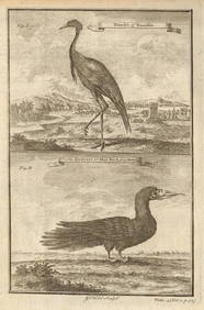
West African Birds. Crane Demoiselle. Alcatrazi or Mad-Bird. Albatross 1745Jasper524.5(9.8k)See Sold PriceFeb 28, 2024
NORTHERN AFRICA. Morocco Tunisia Algeria. Caravan routes.TALLIS/RAPKIN 1851 mapJasper524.5(9.8k)See Sold PriceFeb 28, 2024
NORTHERN AFRICA. Morocco Tunisia Algeria. Caravan routes. RAPKIN/TALLIS 1851 mapJasper524.5(9.8k)See Sold PriceFeb 28, 2024
Cooke, George 1801 Antique Map. West Indies CaribbeanAlbion Auctions4.6(341)See Sold PriceMar 01, 2024
Blackie (Pub) 1882 Folio Map. West USA - Pacific StatesAlbion Auctions4.6(341)See Sold PriceMar 01, 2024
Blackie (Pub) 1882 Folio Map. West India Islands & Central AmericaAlbion Auctions4.6(341)See Sold PriceMar 01, 2024
Robert de Vaugondy - Map of Canada - Mer de l' Ouest or Sea of the West and a Northwest PassageProverde Auctions4.3(3)See Sold PriceFeb 28, 2024