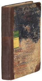
SoldTallis map of Polynesia with HawaiiTitle: Polynesia, or Islands in the Pacific Ocean Author: Tallis, John Description: Steel-engraved map, hand-colored in outline; 4 engraved vignettes. 25x34 cm. (10x13½") plus decorative border.The mSee Sold Price
Sold1852 Tallis Map of Polynesia and the Pacific1852 Tallis Map of Polynesia and the Pacific -- Polynesia or the Islands in the Pacific Ocean. J. Tallis. 1852 London. 13 x 10 in. This is an ornate and highly decorative map of the Pacific Ocean andSee Sold Price
SoldJOHN TALLIS MAP OF POLYNESIA & PACIFIC ISLANDSWith COA. Steelplate engraving, dated 1851. Spots of hand coloring. Dimensions: (Frame) H 19.25" x W 22.5", (Sight) H 10.5" x W 14" Condition: No issues to note.See Sold Price
Tallis: Map of Polynesia & Pacific Islands, 1853Polynesia & the Pacific Islands by Tallis, circa 1853. Original lithograph by John Tallis & Company of London, c. 1853. Map features area from California to Japan and features the Society, Friendly, NSee Sold Price
Tallis: Antique Map of Polynesia & Pacific Islands 1853Title/Content of Map: Polynesia & the Pacific Islands by Tallis, circa 1853 Date Printed: 1853 Cartographer: John Tallis Material/Medium: Lithograph Dimensions: 10.5" x 14" Original lithograph by JohnSee Sold Price
Tallis: Antique Map of Polynesia, 1853Map: Polynesia: Islands of the South Pacific Maker: Tallis Date: circa 1853 Original lithograph by John Tallis & Company of London Map vignettes feature Resolution Bay, Marquesas, the Harbor of Dory,See Sold Price
SoldTallis, John (Pub) 1852 Map. Polynesia. Pacific IslandsSteel Engraved Map with Original Outline Hand Color Published 1852-56 by John Tallis, London for "The Universal Pronouncing Dictionary" by Thomas Wright. Drawn & Engraved by John Rapkin. Centre fold aSee Sold Price
SoldAntique Map, Polynesia, John TallisFramed engraved map, Polynesia or Islands in the Pacific Ocean (c.1850), published by John Tallis and Co., sight: 10''h x 14''w, overall: 17''h x 20''wSee Sold Price
PACIFIC ISLANDS. Polynesia Hawaii Samoa Fiji TongaTITLE/CONTENT OF MAP: 'POLYNESIA, OR ISLANDS IN THE PACIFIC. Mariana or Ladrones, Pelew Islands. or Palaos, Gilbert Islands. or Scarborough Range, Marshall Islands, Otdia or Romanzoff Group, GalapagosSee Sold Price
SoldPACIFIC ISLANDS Polynesia Tahiti Hawaii Samoa FijiTITLE/CONTENT OF MAP: 'POLYNESIA, OR ISLANDS IN THE PACIFIC.Mariana or Ladrones, Pelew Islands. or Palaos, Gilbert Islands. or Scarborough Range, Marshall Islands, Otdia or Romanzoff Group, GalapagosSee Sold Price
SoldPolynesia, Or Islands in the Pacific Ocean.Title/Content of Map: Polynesia, Or Islands in the Pacific Ocean. Date: c1853 Cartographer: RAPKIN, J. Publisher: JOHN TALLIS & COMPANY Size: 8.5Height - 12.75Width Double page plate from an edition iSee Sold Price
SoldTallis. American, Australasian & other mapsTallis (John) a mixed group of American, Australasian and other maps,including Nova Scotia, Canada & New Brunswick, Panama, British Guyana, South Australia, Van Diemen's Island, Polynesia, theSee Sold Price
Pinkerton's Polynesia from Dobson in Phil. 1818Title: Polynesia Author: Pinkerton, John Description: Copper-engraved map, hand-colored. 50x69 cm. (19½x27").American publication of Pinkerton's map of the islands of the Pacific, from Hawaii in theSee Sold Price
Pinkerton's Polynesia from Dobson in Phil. 1818Title: Polynesia Author: Pinkerton, John Description: Copper-engraved map, hand-colored. 50x69 cm. (19½x27").American publication of Pinkerton's map of the islands of the Pacific, from Hawaii in theSee Sold Price
SoldTallis (John) New Zealand; PolynesiaTallis (John) New Zealand; Polynesia, or Islands in the Pacific Ocean; Australia,with decorative borders and vignette views, 3 engraved maps by Rapkin, with original outline hand-colouring, c.See Sold Price
Polynesia, Or Islands in the Pacific Ocean.Title: Polynesia, Or Islands in the Pacific Ocean. Printing Date: c1853 Cartographer: RAPKIN, J. Publisher: JOHN TALLIS & COMPANY Size: 8.5Height - 12.75Width Additional Information: Double page plateSee Sold Price
1850 Tallis Map of Syria / Israel1850 Tallis Map of Syria / Israel J. Tallis 1851 London 13 x 10 in. This is an ornate and highly decorative map of Syria, filled with detail. There is also good detail on present day Lebanon, and IsraSee Sold Price
SoldTallis Map of Africa, 1851Title: 1851 Tallis Map of Africa Cartographer: J. Tallis Published: 1851 London Measurements: 10 x 13 in. Africa. This is an ornate and highly decorative map of Africa featuring five vignettes and fanSee Sold Price
SoldTallis: Map of the Caribbean & West India Islands, 18511851 Tallis Map of the Caribbean -- West India Islands. This is an ornate and highly decorative map of the Caribbean from the Bahamas to Columbia and Venezuela. The map features three vignettes and faSee Sold Price
SoldJohn Tallis: Map of South America, 1851Map: South America Maker: J. Tallis Date: 1851 Origin: London Size: 13 x 10 inches This is an ornate and highly decorative map of South America, filled with detail. There is also good detail on riversSee Sold Price
SoldJohn Tallis: Map of West Canada, 1865Map: West Canada Maker: John Tallis & Co. Date: 1865 Size: Quarto - 8.5 inches high x 11.6 inches wide Scarce third state. Details counties, topography, Lake Ontario, Lake Erie, Lake Huron, etc. VigneSee Sold Price
Tallis Map of Mounts, Rivers, Lakes, 1850Title: 1850 Tallis Map of Western Hemisphere Mounts, Rivers, Lakes Cartographer: J. Tallis Published: 1850 London Measurements: 13 x 10 in. A Comparative View of the Principal Waterfalls, Islands, LakSee Sold Price
SoldTallis: Map of Scotland, 18511851 Tallis Map of Scotland. An excellent and detailed map of Scotland, showing topography, political divisions, transportation routes, including the Caledonian Canal, and towns and cities. Shetland ISee Sold Price
1850 Tallis Map of Syria / Israel -- Syria1850 Tallis Map of Syria / Israel -- Syria 1851 London J. Tallis 13 x 10 in. This is an ornate and highly decorative map of Syria, filled with detail. There is also good detail on present day Lebanon,See Sold Price
1789 Captain James Cook Life & Voyages Australia New Zealand Hawaii KippisSchilb Antiquarian Rare Books4.8(428)See Sold PriceMar 10, 2024
18TH C. ANTIQUE MAP: FRENCH & INDIAN WAR, FRAMEDThomaston Place Auction Galleries4.4(393)See Sold PriceFeb 24, 2024
Keith Haring - Ink on New York Map, Best Buddies, Inscribed, Signed, and DatedSapphire Auction Gallery4.1(67)See Sold PriceMar 02, 2024
Rand McNally Railroad Map Cabinet w/ 21 Railroad MapsRail & Road Auctions4.6(165)See Sold PriceMar 08, 2024
Arrowsmith & Lewis - Map of PolynesiaTrillium Antique Prints & Rare Books4.5(32)See Sold PriceFeb 24, 2024
Putnam - First Map of the State of Ohio by Rufus PutnamTrillium Antique Prints & Rare Books4.5(32)See Sold PriceFeb 24, 2024
Vaillant - Hawaii: Stranding in the Sandwich Islands (Echouage aux Iles Sandwich). 43Trillium Antique Prints & Rare Books4.5(32)See Sold PriceFeb 24, 2024
Vaillant - Kealakekua Bay, Hawaii (Village de Kearakekoua, Iles Sandwich). 44Trillium Antique Prints & Rare Books4.5(32)See Sold PriceFeb 24, 2024
Vaillant - Honolulu, Hawaii (Vue de Honolulu, Iles Sandwich). 45Trillium Antique Prints & Rare Books4.5(32)See Sold PriceFeb 24, 2024
Vaillant - Hawaiian Dance (Scene de Danse aux Iles Sandwich). 42Trillium Antique Prints & Rare Books4.5(32)See Sold PriceFeb 24, 2024
NORTHERN AFRICA. Morocco Tunisia Algeria. Caravan routes. RAPKIN/TALLIS 1851 mapJasper524.5(9.9k)See Sold PriceFeb 28, 2024
NORTHERN AFRICA. Morocco Tunisia Algeria. Caravan routes.TALLIS/RAPKIN 1851 mapJasper524.5(9.9k)See Sold PriceFeb 28, 2024
NORTHERN AFRICA. Morocco Tunisia Algeria. Caravan routes. RAPKIN/TALLIS 1851 mapJasper524.5(9.9k)See Sold PriceFeb 28, 2024
Matson SS Mariposa South Seas Lithograph Travel Cruise PosterClark's Auction Company4.6(443)See Sold PriceMar 03, 2024