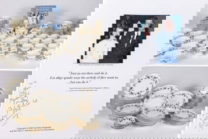
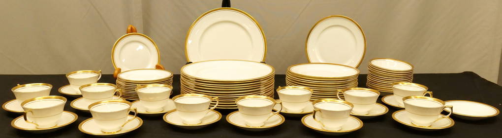
THE FITZGERALD FAMILY TEA and DINNER SERVICEJohn McInnis Auctioneers,LLC4.6(502)See Sold PriceFeb 25, 2024
A CHINESE PORCELAIN GREEN ENAMELED DRAGON MOON FLASK BIANHUBerkeley Auction Gallery4.4(16)See Sold PriceMar 03, 2024
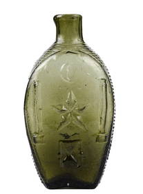
RARE COVENTRY GLASS WORKS MASONIC FLASKJohn McInnis Auctioneers,LLC4.6(502)See Sold PriceFeb 25, 2024
100 Pieces Of Ginori Italian Fruit 1735 ChinaRalph Fontaine Heritage Auctions Inc.4.7(235)See Sold PriceFeb 25, 2024
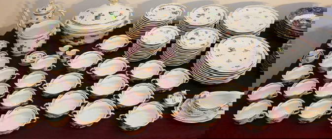
A Fine 19th C. English 183pc Dinnerware Set by CAULDONPremier Auction Galleries4.3(329)See Sold PriceMar 09, 2024
HEREND PORCELAIN "FRUITS & FLOWER" DISH SETThomaston Place Auction Galleries4.4(386)See Sold PriceFeb 25, 2024
Andy Warhol (1928-1987) Space Fruit Cantaloupes IHill Auction Gallery 4.7(1k)See Sold PriceFeb 28, 2024
ARTISTIC CARVING CO "CHESAPEAKE" AMERICAN EAGLEJohn McInnis Auctioneers,LLC4.6(502)See Sold PriceFeb 25, 2024
(5) FINE JAPANESE KONOIKE SILVER DRAGON & IRISES TEA & COFFEE SERVICEAustin Auction Gallery4.7(1.2k)See Sold PriceFeb 25, 2024
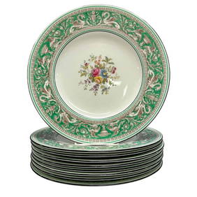
WEDGWOOD Florentine Green Border Dinner PlatesPremier Auction Galleries4.3(329)See Sold PriceMar 09, 2024
Immense 229pc GORHAM Floretine Sterling FlatwarePremier Auction Galleries4.3(329)See Sold PriceMar 09, 2024
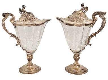
Tiffany & Co Sterling Silver Crystal Ewer Pitcher Figural Pair AntiqueHess Fine Auctions4.5(197)See Sold PriceMar 02, 2024
SoldSurvey of the Cumberland River, 1834 Steamboat Map"Survey of the Cumberland River from the Falls To Nashville with a View to the Removal of the Obstructions to Steam Boat Navigation Between Those Points", made under the direction of Howard Stansbury,See Sold Price
SoldSurvey of the Cumberland River 1834Title: Survey of the Cumberland River from the Falls to Nashville, with a view to the removal of the obstructions to Steam Boat Navigation between those points... Author: U.S. Government Description:See Sold Price
SoldSurvey of the Cumberland River 1834Title: Survey of the Cumberland River from the Falls to Nashville, with a view to the removal of the obstructions to Steam Boat Navigation between those points... Author: U.S. Government Description:See Sold Price
MAP - Kentucky & Tennessee. StansburyKentucky & Tennessee. Capt. M. Howard Stansbury, Survey of the Cumberland River from the Falls to Nashville with a View to the Removal of the Obstructions to Steam Boat Navigation Between Those PointsSee Sold Price
SoldStansbury - Map of the Cumberland River, circa 1834Map of the Cumberland River from the Falls to Nashville, in obedience to a Resolution of Congress dated April 26, 1834 by Howard Stansbury, U.S. Assist. Civ Eng., taken from Matthew Rhea's Map of TenSee Sold Price
Sold8 Tennessee Military & Survey MapsAssorted TN Military & Survey Maps, 8 items total. 1st item: "Survey of Cumberland River. Letter from the Secretary of War transmitting a report of the survey of the Cumberland river. February 24, 183See Sold Price
SoldAtlas of Cumberland County Maine 1871Includes maps of the towns and areas of Cumberland County Maine in 1871. It displays structures with the names of the owners from the survey of the time. The hard cover atlas has been water damaged buSee Sold Price
SoldAN ANTIQUE TEXAS/LOUISIANA BORDER SABINE RIVER SURVEYAN ANTIQUE TEXAS/LOUISIANA BORDER SABINE RIVER SURVEY MAP, "Golfe du Mexique-Texas, Reconnaissance: De la Passe de la Sabine: Dépot de Cartes Plans de la Marine," PARIS,1867, hand colored lithogrSee Sold Price
Sold1834 Map of Kennebec River"The Kennebec River and Adjacent Country Shewing the Routes Examined for a Road from Augusta to the Canada Line in the Direction of Quebec". Reconnoissance made in 1834 by Hartman Bache T.E. & BT. MajSee Sold Price
Tombleson, William 1834 Map of the River Rhine"Tombleson's Upper Rhine" Showing Germany and Switzerland. Steel Engraved Map Published 1832-34, London for "Tombleson's Upper Rhine" Edited by William Gray Fearnside. Illustrated by William TomblesonSee Sold Price
Tombleson, William 1834 Map of the River Rhine"Tombleson's Upper Rhine" Showing Germany and Switzerland. Steel Engraved Map Published 1832-34, London for "Tombleson's Upper Rhine" Edited by William Gray Fearnside. Illustrated by William TomblesonSee Sold Price
Tombleson, William 1834 Map of the River Rhine"Tombleson's Upper Rhine" Showing Germany and Switzerland. Steel Engraved Map Published 1832-34, London for "Tombleson's Upper Rhine" Edited by William Gray Fearnside. Illustrated by William TomblesonSee Sold Price
SoldSacramento River Survey. 1911, 31 maps.Heading: (California - Sacramento River)) Author: United States Army Corps of Engineers Title: Examination and Survey of Sacramento River: from Sacramento to Red Bluff; and Survey from Feather River tSee Sold Price
SoldSurvey of Willamette River Oregon with maps 1892Title: Williamette River, Oregon. Letter...Transmitting, with a letter from the Chief of Engineers, report of an examination and survey of the Willamette River, Oregon Author: Casey, Thomas Lincoln DeSee Sold Price
SoldCumberland and Midlands.- Geological maps.- Mudge (Lt.Cumberland and Midlands.- Geological maps.- Mudge (Lt. Col. William) [Geological Ordnance Survey Map of Cumberland], a composite map of single sheets from the 'Geological Survey of Great Britain' joinSee Sold Price
SoldAttributed to Jacques Tanesse, 1834 MapAttributed to Jacques Tanesse, "Plan of the City and Suburbs of New Orleans From Actual Surveys 1834", [no place], 1834, lithographed map, scarce map showing the fauburgs L'Anunciati, De La Course, SoSee Sold Price
The Surveys in The State of Florida 1853Map Title: (A) Plat Exhibiting the State of the Surveys in The State of Florida Date: 1853 Publisher: Surveyor General's Office: Florida Size: 21.8 x 25 inches Map detailing forts, surveys, rivers, crSee Sold Price
SoldMap Hudson River Showing Steamboat RouteProfessionally framed and matted Map of the Hudson River Showing Route of Day Line Steamers. Back pocket has articles. Measures 32 by 16.5 inches. Property of Katonah EstateSee Sold Price
Poussin: Antique Map of the Tennessee River, 1834Title/Content of Map: Antique plan of the Tennessee River with Muscle Shoals Canal Date: 1834 Cartographer: Poussin, Guillaume Tell Size (inches): 25 x 18 Antique plan of the Tennessee River and propoSee Sold Price
Lot of 2 antique map sections, missisppi river,Lot of 2 antique map sections, missisppi river, geological survey, very oldSee Sold Price
SoldGeneral Map of South AmericaReserve Reduced! Title: General Map of South America Publication Date: 1794 Cartographer: RUSSELL, J. Publisher: H.D. SYMONDS Size: 14.25 x 17.75 "drawn from the best surveys..." Good map showing riveSee Sold Price
General Map of South AmericaTitle/Content of Map: General Map of South America Date Printed: 1794 Cartographer: RUSSELL, J. Size: 14.25X17.75 "drawn from the best surveys..."Good map showing river systems, some topography and plSee Sold Price
Sold1873 US Coast Survey map of Plattsburgh & Cumberland1873 US Coast Survey map of Plattsburgh & Cumberland Bay, NY presented to H. K. Averill, Jr. by the Us Coast Survey 1874 24” x 21.5”See Sold Price
SoldFramed Local Map "Survey of the River Shannon" byFramed Local Map "Survey of the River Shannon" by Arthirs Ferry - 34cm x 68cmSee Sold Price
Central Railroad of New Jersey Map of Sandy Hook Route-ca. 1903JM Hobby Supply and Railroad Artifact Auctions4.4(126)See Sold PriceFeb 24, 2024
Portfolio of 15 County Maps by Robert Morden (English 1650-1703)Nadeau's Auction Gallery4.7(401)See Sold PriceFeb 24, 2024
1883 Mark Twain 1ed Life on the Mississippi St. Louis Missouri Steamboat CLASSICSchilb Antiquarian Rare Books4.8(421)See Sold PriceMar 31, 2024
Nottingham.- Ordnance Survey Office (publisher) Collection 8 geological maps on the environs ofForum Auctions4.3(52)See Sold PriceFeb 29, 2024
INDIA WITHIN THE GANGES SUSAN GOLE ILLUSTRATED MAPS EARLY CARTOGRAPHYJasper524.5(9.8k)See Sold PriceFeb 27, 2024
1834 Malte-Brun Map of the Caribbean -- West India IslandsJasper524.5(9.8k)See Sold PriceFeb 27, 2024
WEST AFRICA Explorers' routes Senegal Ashanti. Mountains of Kong. SDUK 1857 mapJasper524.5(9.8k)See Sold PriceFeb 28, 2024
NORTH & WEST AFRICA. Sahara Niger river 'Zaara ou le Desert'. MALLET 1683 mapJasper524.5(9.8k)See Sold PriceFeb 28, 2024
Northern & Southern Africa. Maghreb. Orange River Sovereignty. HALL 1854 mapJasper524.5(9.8k)See Sold PriceFeb 28, 2024
La Barbarie de la Nigritie et de la Guinée'. West Africa. DE L’ISLE 1745 mapJasper524.5(9.8k)See Sold PriceFeb 28, 2024
A LARGE ERRATA BOOK INDIAN MAPS AND STUDIES including the provinces of Bengal, Cossimbuzar Island, THannam's Auctioneers Ltd4.3(386)See Sold PriceFeb 27, 2024
John Senex Map of Louisiana & Mississippi RiverWillow Auction House4.5(283)See Sold PriceMar 14, 2024