Marc Chagall-Limited Edition -Paris Opera Ceiling after ChagallArt Legacy Auctions4.5(223)See Sold PriceFeb 24, 2024
Salvador Dali Pantagruel Limited Edition Lithograph Hand signed and numberedArt Legacy Auctions4.5(223)See Sold PriceFeb 24, 2024
Pablo Picasso Bouquet of Peace Collection Domaine Picasso Limited Edition on paper.Art Legacy Auctions4.5(223)See Sold PriceFeb 24, 2024
A RARE MAXFIELD PARRISH JACK AND THE BEANSTALK PRINTSoulis Auctions4.8(953)See Sold PriceFeb 24, 2024
LARGE MECHANICAL PRINT 'STARS' AFTER MAXFIELD PARRISHSoulis Auctions4.8(953)See Sold PriceFeb 24, 2024
Heinrich Aldegrever, etc. 15 old master prints. 16th-17th centuries. Aldegrever works include "ManTremont Auctions4.5(297)See Sold PriceFeb 25, 2024
United States of North AmericaTitle: United States of North America Publication Date: 1872 Cartographer: STANFORD, EDWARD Dimensions: 12Height - 14.5Width Publisher: STANFORD, EDWARD Map showing U.S., Lower California (peninsula),See Sold Price
Stanford: Antique Map of the United States, 1873Title: Stanford's Map of the United States and Part of the Dominion of Canada. Stanford's 1873 map of the U.S. with detailed geography of the West Map maker: Edward Stanford Place and Year: London, 18See Sold Price
Sold1845 MITCHELL'S REFERENCE & DISTANCE WALL MAP U.S.SHOWING MITCHELL'S 1845 REFERENCE AND DISTANCE WALL MAP OF THE UNITED STATES WITH GENERAL MAP OF THE US WITH CONTIGUOUS BRITISH AND MEXICAN POSSESSIONS.PHILADELPHIA : S. AUGUSTUS MITCHELL COPPER-ENGRASee Sold Price
SoldAJ Nystrom 2-Sided Chalkboard School Map, US & WorldLarge AJ Nystrom Roll Up 2 Sided Chalkboard Classroom Map Chart, US & World. Wonderful chart has maps of the United States and the World outlined in yellow on a black chalkboard backing. From the RoyaSee Sold Price
Sold1899 Jones Map U.S. Indian Reservations"Map showing Indian Reservations within the limits of the United States compiled under the direction of the Hon. W. A. Jones Commissioner of Indian Affairs 1899". Includes inset maps of Alaska, CalifoSee Sold Price
SoldAN ANTIQUE SURVEY MAP, "U.S. Coast Survey: GalvestonAN ANTIQUE SURVEY MAP, "U.S. Coast Survey: Galveston Entrance," CIRCA 1867, lithograph on paper, No. 13, a United States Coast Survey, Benjamin Pierce, Superintendent, "The Triangulation was executedSee Sold Price
SoldGERMAN WWII LUFTWAFFE NAVIGATION MAP, U.S. CAPTUREFramed German WWII 1938 Luftwaffe navigation map, "Luft-Navigationskarte In Merkatorprojektion" showing England, Scotland, Ireland, Norway, Belgium, Northern France, written in ink at lower center: "OSee Sold Price
Sold1873 Skeleton Map US Territory West of Missisippi"Skeleton Map Of the Territory of the United States west of the Mississippi River Exhibiting the Relations Existing Between Lines And Areas Of Explorations & Surveys Conducted under the auspices of thSee Sold Price
SoldJapan Old Map / US Department of State 1947Japan Old Map / US Department of State 1947 / 47 big maps (63cm x 51cm) / 100% Japanese territory / Uninhabited island /See Sold Price
Sold1805 Wm. Kneass Map U.S. and Parts of LouisianaFrom A Geographical Dictionary of the United States of North America by Joseph Scott. Good condition; age toning, slight roll along top, small tear right side (with scotch tape repair to reverse), etcSee Sold Price
SoldAN ANTIQUE SURVEY MAP, "U.S. Coast Survey: PreliminaryAN ANTIQUE SURVEY MAP, "U.S. Coast Survey: Preliminary Sketch of Galveston Bay, Texas," SECOND EDITION, CIRCA 1852, lithograph on paper, map "I, No. 2," A.D. Bache, Superintendent, "Verified by I.I.See Sold Price
SoldAN ANTIQUE RECONSTRUCTION ERA SURVEY MAP, "U.S. CoastAN ANTIQUE RECONSTRUCTION ERA SURVEY MAP, "U.S. Coast Survey, Sketch 1, Showing the Progress of the Survey in Section IX from 1848-1875," 1875, lithograph on paper, showing the Texas Gulf Coastline frSee Sold Price
Sold(2) 1893 MAP U.S. INDIAN TERRITORIES & WATER MAP(lot of 2) Framed "Map of Aboriginal America Showing the Distribution and Territorial Limits of The Indian Nations, In The New World", taken from the "Columbian Atlas of the World We Live In", Hunt &See Sold Price
1985 Large Map- U.S. POTATO HARVEST SEASONS By COUNTY****** Real potato map*** W28.5" H22 1/4" Very nice and definitely very rare !!!!! Don't miss your treasure! ********See Sold Price
SoldStanford Map of PalestineSTANFORD, Edward (1827-1904). Palestine with the Huran and the adjacent districts. Lithograph with original hand color from the Society for the Diffusion of Useful Knowledge. London: Edward Stanford,See Sold Price
SoldStanford Map of North AmericaSTANFORD, Edward (1827-1904). North America (Sheet II) The dominion of Canada, parts of Quebec and New Brunswick... Lithograph with original hand color from the Society for the Diffusion of Useful KnoSee Sold Price
SoldStanford Map of South AfricaSTANFORD, Edward (1827-1904). South Africa. Lithograph with original hand color from the Society for the Diffusion of Useful Knowledge. London: Edward Stanford, 1857-1870. 17 1/4" x 13 3/4" sheet.See Sold Price
SoldMap U.S. Dept. of the Interior, U.S. Geologic SurveyBeautiful full color map of United States, a Tapestry of Time and Terrain. 56" x 40". Date: c2000 State/Country: City/County:See Sold Price
SoldAntique Map US Rail Roads and Wagon Roads"Map of the Untied States showing the Limits Within Which Land Grants were Made by the Federal Government to Aid in the Construction of Railroads and Wagon Roads". Engraved and printed for the 9th CenSee Sold Price
Sold1882 Stanford Map of Ceylon (Sri Lanka) -- CeylonTitle/Content of Map: 1882 Stanford Map of Ceylon (Sri Lanka) -- Ceylon Date: 1882, London Cartographer: E Stanford Size: 13 X 10.6 in. This is a fantastic map of Ceylon (Sri Lanka). Extraordinary detSee Sold Price
SoldTwo 1930s Maps US Coast Geodetic Survey Jersey Delaware1) 1939 US Coast Geodetic Survey New Jersey / Delaware approx. 34.5 x 39.25 in; 2) 1937 Maryland / VirginiaNo. 1220 approx. 41 x 34.5. Weight 9 oz. Note: Photo of both maps is not to scale.See Sold Price
SoldPRE-WWII ERA GERMAN MAPS & US ARMY DOC COPIES LOTPRE-WWII ERA GERMAN MAPS & US ARMY DOC COPIES LOT Lot of Pre-WWII era German Military maps & copies of US army personal file documents. Numerous German Military maps dating from 1925, to 1936 of varioSee Sold Price
Sold2nd BN 417th Infantry 76 Div. WWII Colorful Cartoon Map2nd BN 417th Infantry 76 Div. WWII Colorful Cartoon map. US Soldiers in Europe. Has some slight discoloration but is in overall excellent condition. Measures approx. 22" tall x 29" wide. You aSee Sold Price
FLYING A TOURING SERVICE U.S. ROAD MAPS TIN WALL DISPLAY.Dan Morphy Auctions4.2(1.3k)See Sold PriceFeb 25, 2024
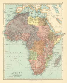
Africa. Congo Free Trade Area. British South Africa Company. STANFORD 1896 mapJasper524.5(9.9k)See Sold PriceFeb 28, 2024
Northwest Africa. Morocco Sahara Rio do Oro Ain Sefra Gardaia. STANFORD 1904 mapJasper524.5(9.9k)See Sold PriceFeb 28, 2024
Central Africa. Congo Free State Rhodesia German East Africa. STANFORD 1896 mapJasper524.5(9.9k)See Sold PriceFeb 28, 2024
Africa. French West/Equatorial. Tanganyika Belgian Congo. STANFORD c1925 mapJasper524.5(9.9k)See Sold PriceFeb 28, 2024
Africa. Congo Free Trade Area. British South Africa Company. STANFORD 1894 mapJasper524.5(9.9k)See Sold PriceFeb 28, 2024
Northwest Africa. Morocco Sahara Rio do Oro Ain Sefra Gardaia. STANFORD 1904 mapJasper524.5(9.9k)See Sold PriceFeb 28, 2024