LOT OF 8 1767 VITRUVIUS BRITANNICUS ARCHITECTURAL ENGRAVINGSMarnie Collection Auction4.5(70)See Sold PriceMar 10, 2024
Francis Bacon (British, 1909-1992) Offset Lithograph in Colors, Ca. 1980, "Portrait of IsabelDuMouchelles4.6(830)See Sold PriceMar 15, 2024
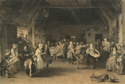
After Sir David Wilkie (British, 1785-1841) Engraving on Paper, Ca. 1832, "The Penny Wedding", H 16"DuMouchelles4.6(830)See Sold PriceMar 15, 2024
ORIGINAL ANTIQUE ARCHITECTURAL ENGRAVING VITRUVIUS BRITANNICUSMarnie Collection Auction4.5(70)See Sold PriceMar 10, 2024
ORIGINAL ANTIQUE ARCHITECTURAL ENGRAVING VITRUVIUS BRITANNICUSMarnie Collection Auction4.5(70)See Sold PriceMar 10, 2024
Phillip Sutton (British, B. 1928) Woodcut 1969, "Edna", H 18" W 17.75"DuMouchelles4.6(830)See Sold PriceMar 15, 2024
Michael Challenger (British, B. 1939) Lithograph 1969, "Lunar Tables", H 12" W 19"DuMouchelles4.6(830)See Sold PriceMar 15, 2024
SoldStanford Map of the British IslesSTANFORD, Edward (1827-1904). British Isles. Lithograph with original hand color from the Society for the Diffusion of Useful Knowledge. London: Edward Stanford, 1857-1870. 17 1/4" x 13 3/4" sheet.See Sold Price
SoldMaps C1850-1908 Mixed Lot of 7 MapsMixed Lot of Engraved and Lithographed Maps. Incl German Empire, Europe, Canaan/Palestine, Central Europe, Zoological Regions of the World and British Isles. Examples by Stanford/Medland, Weller, GoldSee Sold Price
SoldMaps 1842-1920. Mixed Lot of 10Incl British Isles, Canada, Australia, Turkey/Greece, Persia, Syria, Asia Continent, Turkey in Asia, and Russia in Asia. Examples by Blackie/Weller, Starling, Stanford, and Gross. Paper Size: Up to 27See Sold Price
SoldTallis, John (Pub) 1852 Map. British IslesSteel Engraved Map with Original Outline Hand Color Published 1852-56 by John Tallis, London for "The Universal Pronouncing Dictionary" by Thomas Wright. Drawn & Engraved by John Rapkin. Centre fold aSee Sold Price
SoldMap, British Isles, Joannes Jansson, mid 17th CenturyEarly map, British Isles, by Joannes Jansson (Amsterdam) mid 17th Century, "MONA INSULA Vulgo ANGLESEY. ; MONA INSULA Vulgo THE ISLE OF MAN. ; VECTIS INSULA Anglice THE ISLE WIGHT", 18" by 22"See Sold Price
SoldBartholomew, John 1904 Geological Map. British Isles"General Geological Features of the British Isles" Lithograph Map Published 1904, London for "The Survey Gazetteer of the British Isles" Uncommon First Edition by John Bartholomew. Centre fold as issuSee Sold Price
ANTIQUE MAGNA BRITANNIA MAP BRITISH ISLES & FRANCEANTIQUE MAGNA BRITANNIA MAP BRITISH ISLES AND FRANCE W 20" L 20":. For a high resolution photo CLICK HERESee Sold Price
Rare Map British Isles Abbe Gaultier 1799Wauthier, Mr. ( Gaultier, Abbe ) MAP - A MAP OF THE BRITISH ISLES ACCORDING TO THE METHOD OF ABBE GAULTIER Published in 1799, measures 15" x 18". Published by John Harris and Son. This very scarce mapSee Sold Price
SoldTwo Maps, British Isles, Roman EmpireA New Map of the British Isles..., by Sutton Nicholls, after Edward Wells, published circa 1700, Oxford, showing England, Scotland, and Ireland "in the time of the Romans", elaborate title cartouche uSee Sold Price
Soldmap, British Isles, Dufour, Pilon, DyonnetFramed handcolored engraved map, ''Iles Britanniques,'' (1850) by Charles Dyonnet, 19th century, published in ''Geographie Moderne, Atlas Universel,'' sight: 30''h x 21.5''w, overall: 44.5''h x 32.5''See Sold Price
Soldmap, British Isles, Dufour, Pilon, DyonnetFramed handcolored engraved map, ''Iles Britanniques,'' (1850) by Charles Dyonnet, 19th century, published in ''Geographie Moderne, Atlas Universel,'' sight: 30''h x 21.5''w, overall: 44.5''h x 32.5''See Sold Price
SoldGuthrie, William 1799 Pair of Maps. British IslesCopper Engraved Maps Published 1799, London for "A New Geographical, Historical and Commercial Grammar..." by William Guthrie. The maps are by D. Ogilby & Son and others. Folds as issued. Paper Size:See Sold Price
Sold5 Maps, British Isles, Misc. Publishers, c.1762-1805LOT. 5 maps relating to the British Isles, various publishers, c.1762-1805, includes: Kitchin. Ireland with the Roads, from the latest Surveys. 36.7x34 cm. (Some offsetting, 3" tear near centerfold.)See Sold Price
SoldMAPS - BRITISH ISLES MAPS - BLAEU, Willem JanszooMAPS - BRITISH ISLES MAPS - BLAEU, Willem Janszoon (1571-1638). Anglia Regnum; Scotia Regnum; Magna Britanniae; Hibernia Regnum.Amsterdam: 1638. 4 engraved maps of the British Isles, French teSee Sold Price
Sold5 Maps, British Isles, Misc. Publishers, c.1762-18LOT. 5 maps relating to the British Isles, various publishers, c.1762-1805, includes: Kitchin. Ireland with the Roads, from the latest Surveys. 36.7x34 cm. (Some offsetting, 3" tear near centerfold.)See Sold Price
Group of Maps, British Isles, Massachusetts Harbors,Group of maps, to include: The British Isles; Bass River Harbor, Massachusetts; Monomoy Harbor, Massachusetts; Britannia Romana; Massachusetts, Connecticut & Rhode Island Railroad Routes. Largest 19"See Sold Price
SoldBritish Isles.Reserve Reduced! Title/Content of Map: British Isles.Date: 1840 Cartographer: GREENLEAF, JEREMIAH Material/Medium: JEREMIAH GREENLEAF Size: 12.5 x 10.75 inches Showing topography, many place names. MaSee Sold Price
Seutter: Antique Map of the British Isles, 1740Title/Content of Map: British Isles by Seutter Date Printed: C1740 Cartographer: Matthaus Seutter Material/Medium: Paper Size: 23" x 19" Original hand colored copperplate engraved. Published in AugsbuSee Sold Price
British isles.Title/Content of Map: British isles. Date: 1598/99. Cartographer: Ruscelli Size: 11x9”. Provenance: Venice. Reserve: $500.00 Shipping: Domestic: Free shipping to anywhere within the contiguous U.S.See Sold Price
"British Isles" by John Thomson. England IrelandTITLE/CONTENT OF MAP: 'British Isles' The top image on the right hand side shows the entire map. To view a close up of the map showing the level of printed detail, please click on the bottom image onSee Sold Price
Transport Map of Central Europe. Railways mail routes. LARGE 1952 oldTITLE/CONTENT OF MAP: British Isles - Railways [inset Glasgow District; Edinburgh District; Leeds District; Liverpool & Manchester District; Birmingham District; Nottingham District; Potteries DistricSee Sold Price
British Isles Railways companies regions. Ireland. GWR LMSR LNER. LARGE 1927 mapTITLE/CONTENT OF MAP: British Isles - Railways [inset Glasgow District; Edinburgh District; Leeds District; Liverpool & Manchester District; Birmingham District; Nottingham District; Potteries DistricSee Sold Price
SoldTOBIAS LOTTER MAP OF BRITISH ISLESOriginal hand-colored engraving. 18th century. Three different hand-colored heraldic devices. Dimensions: (Frame) H 30.5" x W 26.5", (Sight) H 23.75" x W 20" Condition: Some light foxing. Unexamined oSee Sold Price
LATE 17TH C. FRENCH MAP OF THE NEW WORLD BY ALEXIS-HUBERT JAILLOT (1632-1712)Thomaston Place Auction Galleries4.4(393)See Sold PriceFeb 24, 2024
ATTR TO LIBERTY COMPANY ARTS CRAFTS COPPER MIRRORAntique Arena Inc.4.5(878)See Sold PriceFeb 24, 2024
ARTS AND CRAFTS HAMMERED LAMP BY FREDRICK FIFIELDAntique Arena Inc.4.5(878)See Sold PriceFeb 24, 2024
AN ANTIQUE FOLDING MAP OF THE BRITISH ISLES DATED 1873Hutchinson Scott Auctioneers4.4(42)See Sold PriceFeb 28, 2024
Chatelain - 3 Maps of the British Isles (England, Ireland, Scotland)Trillium Antique Prints & Rare Books4.5(32)See Sold PriceFeb 24, 2024
De Jode, Rare, pub. 1593 - Map of the British Isles [England, Scotland, Ireland] (Angliae Scotiae etTrillium Antique Prints & Rare Books4.5(32)See Sold PriceFeb 24, 2024
Map: A 17thC engraved map of the British Isles titled A Generall Mapp of the Isles of GreatClaydon Auctioneers Ltd4.3(125)See Sold PriceFeb 26, 2024
Africa. Congo Free Trade Area. British South Africa Company. STANFORD 1896 mapJasper524.5(9.9k)See Sold PriceFeb 28, 2024
Africa. Congo Free Trade Area. British South Africa Company. STANFORD 1894 mapJasper524.5(9.9k)See Sold PriceFeb 28, 2024
Stanford, Edward 1901 Large Map. Geological Map of the British IslesAlbion Auctions4.6(341)See Sold PriceMar 01, 2024
Stanford, Edward 1901 Large Map. Hydrographical Map of the British IslesAlbion Auctions4.6(341)See Sold PriceMar 01, 2024
Stanford, Edward 1901 Large Map. Stereographical Map of The British IslesAlbion Auctions4.6(341)See Sold PriceMar 01, 2024
Paterson & Mogg 1822 Pair of British Road Maps. Isle of Thanet & WightAlbion Auctions4.6(341)See Sold PriceMar 01, 2024


![De Jode, Rare, pub. 1593 - Map of the British Isles [England, Scotland, Ireland] (Angliae Scotiae et (1 of 2)](https://p1.liveauctioneers.com/6581/319571/171593327_1_x.jpg?height=282&quality=70&version=1707853304)


