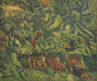
Chaim Soutine (Belarusian/French, 1893-1943) - La Petite Fille dans la VerdureFreeman's | Hindman4.5(158)See Sold PriceFeb 27, 2024
Elisabeth Frink (British, 1930-1993) - Harbinger Bird IFreeman's | Hindman4.5(158)See Sold PriceFeb 27, 2024
AMERICAN SEASCAPE PAINTING BY ROSS EMBROSE MOFFETTAntique Arena Inc.4.5(883)See Sold PriceMar 02, 2024
CHARLES HENRY GIFFORD (Massachusetts, 1839-1904), Luminist view of three sailboats in a quietEldred's4.7(423)See Sold PriceFeb 28, 2024
RARE MANHATTAN PROJECT GLASS LEADED FROM THE MANHATTAN PROJECT WORLD WAR II WW2 724 GRAMSCol. Christie Hatman Auctioneers4.4(355)See Sold PriceFeb 26, 2024
Estate Fresh Civil War Cavalry C. Roby 1863 With ScabbardRalph Fontaine Heritage Auctions Inc.4.7(236)See Sold PriceFeb 25, 2024
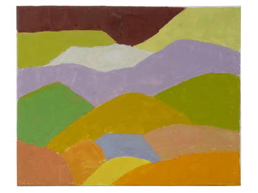
ABSTRACT ARAB LEBANESE OIL PAINTING BY ETEL ADNANAntique Arena Inc.4.5(883)See Sold PriceMar 02, 2024
SoldStanford (Edward) Stanford's Library Map of Africa, NewStanford (Edward) Stanford's Library Map of Africa, New Edition, colour-keyed to indicate the imperial possessions of various European nations (Britain, France, Portugal, Italy, Spain and Belgium), anSee Sold Price
Sold(AFRICA.) Stanford, Edward. Stanford's Library Map of(AFRICA.) Stanford, Edward. Stanford's Library Map of Africa. New Edition, 1892. Large lithographed case map of Colonial Africa in 4 sections, each segmented and mounted to original linen with marbledSee Sold Price
Sold-. Stanford (Edward) Stanford's Library Map of Aus-. Stanford (Edward) Stanford's Library Map of Australasia,Constructed by A. Keith Johnston F.R.S.A., F.R.G.S., 1st edition wall map from Borneo to New Zealand, with inset chart of the world sSee Sold Price
SoldSouth Africa.- The Second Boer War.- Stanford & Co.South Africa.- The Second Boer War.- Stanford & Co. (Edward) The Crisis in South Africa - Stanford's New Map of the The Orange Free State, the Southern part of The South African Republic, The NorthernSee Sold Price
Stanford's New Library chart of the World 1920Title/Content of Map: Stanford's New Library chart of the World 1920 Publication Date: 12 01 1920 Cartographer: Publisher: Edward Stanford Description: Elegant, beautifully colord map just post-WWI. TSee Sold Price
Stanford's New Library chart of the World 1920Title: Stanford's New Library chart of the World 1920 Publication Date: 7641 Cartographer: Publisher: Edward Stanford Brief Description: Elegant, beautifully colord map just post-WWI. The British EmpiSee Sold Price
SoldStanford (Edward) Stanford's Library Map of AsiaStanford (Edward) Stanford's Library Map of Asia,engraved map on 4 sheets, disected onto linen, outline colouring, [c.1895] 1480 x 1600mm § Keller's Road Map of Switzerland, engraved map, dissSee Sold Price
SoldStanford (Edward) - Stanford's Library Map of Londonlarge folding engraved map in 4 parts, each dissected and linnen-backed, hand-coloured in outline, light finger soiling and dusting, blue and gold paper covers with index map labels, each sheet measurSee Sold Price
Sold-. Stanford (Edward) Stanford's Library Map of Lon-. Stanford (Edward) Stanford's Library Map of London and its Suburbs,engraved folding map, hand coloured, on 4 sheets, dissected and laid to linen, 1880 x 1740mm, [c.1871 or later].See Sold Price
SoldStanford (Edward). Stanford's Library Map of London andStanford (Edward) Stanford's Library Map of London and its Suburbs, large engraved map with hand-colouring, on four sheets, each dissected and linen-backed with marbled ends and index map labels, eachSee Sold Price
STANFORD, EDWARD. Stanford's Library Map of the WorldSTANFORD, EDWARD. Stanford's Library Map of the World on Mercator's Projection. Large lithographed case map of the world. 38x68 inches overall, dissected into 40 segments and mounted to original linenSee Sold Price
SoldBLON Stanford (Edward) Stanford's Library Map of LBLON Stanford (Edward) Stanford's Library Map of London and its Suburbsincluding detailed depictions of all the main parks including Crystal Palace in Sydenham Hill, engraved map with hand-colSee Sold Price
Stanford (Edward) Stanford's Library Map of LondonStanford (Edward) Stanford's Library Map of London and its Suburbsincluding detailed depictions of all the main parks including Crystal Palace in Sydenham Hill, engraved map with hand-colourinSee Sold Price
SoldSTANFORD, EDWARD. Stanford's Library Map of the WorldSTANFORD, EDWARD. Stanford's Library Map of the World on Mercator's Projection. Large lithographed case map of the world. 38x68 inches overall, dissected into 40 segments and mounted to original linenSee Sold Price
SoldStanford Library Map of London & its SuburbsStanford (Edward) Stanford's Library Map of London and its Suburbs,large scale map from Hornsey to South Norwood, and from Hammersmith to Greenwich, engraved map with original hand-colouring,See Sold Price
SoldStanford (Edward) 24 engraved sheets on the scaleStanford (Edward) Stanford's Library Map of London and Its Suburbs, 24 engraved sheets on the scale of six inches to a mile, with key map as front paste-down, each c.360 x 435mm., first sheetSee Sold Price
SoldJOHNSTON, A. KEITH; and STANFORD, EDWARD. EdwaJOHNSTON, A. KEITH; and STANFORD, EDWARD. Edward Stanford's Library Map of North America constructed by A. Keith Johnston. Large hand-colored lithographed case map in 4 parts, each part consisting ofSee Sold Price
SoldStanford (Edward) Library Map of LondonStanford (Edward) Library Map of London and its Suburbs, upper 2 sheets only, of 4, from Crouch End to Lambeth Bridge, and from Kensal Green to West Ham, showing the International Exhibition,See Sold Price
SoldSTANFORD, EDWARD. Stanford's New Map of the GreaterSTANFORD, EDWARD. Stanford's New Map of the Greater Part of Europe Extending from Moscow to the Atlantic & from the Gulf of Bothnia to the Mediterranean Distinguishing the Political Divisions, RailwaySee Sold Price
SoldStanford (Edward) Stanford's New Map of the CountyStanford (Edward) Stanford's New Map of the County of London, On the Scale of Four Inches to One Mile,in 5 parts, showing from Wood Green down to Thornton Heath, and Plumstead Marshes across tSee Sold Price
SoldStanford (E) Library Map of LondonStanford (Edward) Library Map of London and its Suburbs, 4 folding engraved linen-backed maps, each dissected into 20 sections with part original hand-colouring, each opening to 980 x 850mm.,See Sold Price
STANFORD, EDWARD; and ALEXANDER KEITH JOHNSTON.STANFORD, EDWARD; and ALEXANDER KEITH JOHNSTON. Stanford's Library Map of Asia. Large hand-colored engraved case map in 4 sections, each segmented and mounted to original linen with marbled paper selfSee Sold Price
SoldStanford (E) Map of Metropolitain RailwaysStanford (Edward) Publisher.- A New Map of Metropolitain Railways & Miscellaneous Improvements Deposited at the Private Bill Office, Nov. 30, 1863, for session 1864,a standard metropolitan mapSee Sold Price
SoldMiddle East.- Stanford (Edward) Stanford's Map of PartMiddle East.- Stanford (Edward) Stanford's Map of Part of The Turkish Empire, with Lower Egypt, The New Balkan Provinces and Greece, large folding map, lithograph partly printed in colour, 1180 x 815See Sold Price
Africa. Congo Free Trade Area. British South Africa Company. STANFORD 1896 mapJasper524.5(9.9k)See Sold PriceFeb 28, 2024
Central Africa. Congo Free State Rhodesia German East Africa. STANFORD 1896 mapJasper524.5(9.9k)See Sold PriceFeb 28, 2024
South Namibia coast. Walvis Bay-Orange River ADMIRALTY sea chart 1881 (1954) mapJasper524.5(9.9k)See Sold PriceFeb 28, 2024
Africa. Congo Free Trade Area. British South Africa Company. STANFORD 1894 mapJasper524.5(9.9k)See Sold PriceFeb 28, 2024
Stanford, Edward 1901 Large Map. Burma and Adjacent CountriesAlbion Auctions4.7(341)See Sold PriceMar 01, 2024
Stanford, Edward 1901 Large Map. Sea of Marmara. TurkeyAlbion Auctions4.7(341)See Sold PriceMar 01, 2024
Stanford, Edward 1901 Large Map. Geological Map of the British IslesAlbion Auctions4.7(341)See Sold PriceMar 01, 2024
Stanford, Edward 1901 Large Map. Hydrographical Map of the British IslesAlbion Auctions4.7(341)See Sold PriceMar 01, 2024
Stanford, Edward 1901 Large Map. Stereographical Map of The British IslesAlbion Auctions4.7(341)See Sold PriceMar 01, 2024
ANTIQUE ILLUSTRATED HANDBOOK OF GEOGRAPHY AND TRAVEL IN ASIA, VOLUME 2, 1896NY Elizabeth 4.1(88)See Sold PriceMar 03, 2024


![[Tintype] Massive Bowie knife (1 of 1)](https://p1.liveauctioneers.com/7226/317626/170485482_1_x.jpg?height=282&quality=70&version=1706368022)
![[Ambrotype] Magnificent Portrait (1 of 1)](https://p1.liveauctioneers.com/7226/317626/170485477_1_x.jpg?height=282&quality=70&version=1706368022)


![[Tintype] Native American Man w/ Knife (1 of 2)](https://p1.liveauctioneers.com/7226/317626/170485453_1_x.jpg?height=282&quality=70&version=1706368022)
![[REES, Charles] Enlistedman w/ Bowie Knife (1 of 1)](https://p1.liveauctioneers.com/7226/317626/170485489_1_x.jpg?height=282&quality=70&version=1706368022)
![[Ambrotype] Wounded at Gettysburg (1 of 1)](https://p1.liveauctioneers.com/7226/317626/170485471_1_x.jpg?height=282&quality=70&version=1706368022)


![[Ambrotype] Young Soldier w/ Bowie Knife (1 of 1)](https://p1.liveauctioneers.com/7226/317626/170485459_1_x.jpg?height=282&quality=70&version=1706368022)

![[Daguerreotype] Soldier w/ Bowie Knife (1 of 2)](https://p1.liveauctioneers.com/7226/317626/170485458_1_x.jpg?height=282&quality=70&version=1706368022)
![[Tintype] Soldier w/ Flowers (1 of 1)](https://p1.liveauctioneers.com/7226/317626/170485495_1_x.jpg?height=282&quality=70&version=1706368022)
![[Tintype] Identified North Carolina Infantryman (1 of 2)](https://p1.liveauctioneers.com/7226/317626/170485474_1_x.jpg?height=282&quality=70&version=1706368022)