1798 BIBLE FIRST HOT PRESS EDITION LARGE FOLIO antique AMERICANA 18th cent. RAREJasper524.5(9.8k)See Sold PriceFeb 28, 2024
JOHN THOMPSON AUTOGRAPHED SIGNED NL BASEBALL PSA - GEORGETOWN HOYAS COACH3 Kings Auction4.3(194)See Sold PriceFeb 26, 2024
Spanish North America. THOMSON. Texas, Mexico & Southwestern USA 1817 mapTitle: "Spanish North America". THOMSON. Texas, Mexico & Southwestern USA 1817 map Description: Spanish North America [northern part] by Drawn & engraved for John Thomson's "New General Atlas" (PublisSee Sold Price
Spanish North America. THOMSON. Texas, Mexico & Southwestern USA 1830 mapTitle: "Spanish North America". THOMSON. Texas, Mexico & Southwestern USA 1830 map Description: Spanish North America [northern part] by Drawn & engraved for John Thomson's "New General Atlas" (1830).See Sold Price
Thomson: Antique Map of Spanish North America, 1817Title/Content of Map: 'Spanish North America [northern part]' A large map of Texas, Mexico and the American Southwest, published in Edinburgh by John Thompson, based on the explorations of Humboldt anSee Sold Price
Thomson: Antique Map of Spanish North America, 1817Title/Content of Map: 'Spanish North America [northern part]' A large map of Texas, Mexico and the American Southwest, published in Edinburgh by John Thompson, based on the explorations of Humboldt anSee Sold Price
Thomson: Antique Map of Spanish North America, 1817TITLE/CONTENT OF MAP: 'Spanish North America [northern part]' A large map of Texas, Mexico and the American Southwest, published in Edinburgh by John Thompson, based on the explorations of Humboldt anSee Sold Price
SoldSpanish North America. THOMSON. Texas, Mexico &TITLE/CONTENT OF MAP: 'Spanish North America [northern part]' A large map of Texas, Mexico and the American Southwest, published in Edinburgh by John Thompson, based on the explorations of Humboldt anSee Sold Price
"Spanish North America". THOMSON. Texas, Mexico &TITLE/CONTENT OF MAP: Spanish North America [northern part] A large map of Texas, Mexico and the American Southwest. There are extensive observations of Native American Indian settlements and huntingSee Sold Price
"Spanish North America". THOMSON. Texas, Mexico &TITLE/CONTENT OF MAP: 'Spanish North America [northern part]' A large map of Texas, Mexico and the American Southwest, published in Edinburgh by John Thompson, based on the explorations of Humboldt anSee Sold Price
"Spanish North America". THOMSON. Texas, Mexico &TITLE/CONTENT OF MAP: 'Spanish North America [northern part]' A large map of Texas, Mexico and the American Southwest, published in Edinburgh by John Thompson, based on the explorations of Humboldt anSee Sold Price
Spanish North America. THOMSON. Texas, Mexico &TITLE/CONTENT OF MAP: 'Spanish North America [northern part]' A large map of Texas, Mexico and the American Southwest, published in Edinburgh by John Thompson, based on the explorations of Humboldt anSee Sold Price
SoldJohn Thomson, Spanish North America, double pageJohn Thomson, Spanish North America, double page engraved map of Texas and Mexico, sight size 20 3/4" x 25". Provenance: Property from the Credit Suisse Americana Collection.See Sold Price
SoldAN ANTIQUE MAP, "Spanish North America," 1814,AN ANTIQUE MAP, "Spanish North America," 1814, hand colored engraving on paper, "Drawn and Engraved for Thomson's New General Atlas..." 20" x 25" Note: "A large map of Texas, Mexico and the American SSee Sold Price
SOUTH WESTERN USA & NORTHERN MEXICO California & TexasTITLE/CONTENT OF MAP: 'NORTH AMERICA, SHEET XV., Utah, New Mexico, Texas, California, &c., and the northern states of Mexico' DATE PRINTED: 1874 IMAGE SIZE: Approx 33.5 x 41.5cm, 13 x 16.25 inches (LaSee Sold Price
SOUTH WESTERN USA & NORTHERN MEXICO California & TexasTITLE/CONTENT OF MAP: 'NORTH AMERICA, SHEET XV., Utah, New Mexico, Texas, California, &c., and the northern states of Mexico' DATE PRINTED: 1874 IMAGE SIZE: Approx 33.5 x 41.5cm, 13 x 16.25 inches (LaSee Sold Price
SoldSDUK: Antique Map of Southwestern USA, 1846CENTRAL AMERICA, SHEET II., INCLUDING TEXAS, CALIFORNIA AND THE NORTHERN STATES OF MEXICO' The map, published in 1846, shows the Republic of Texas as an independent state as it existed between 1836 anSee Sold Price
Sold18th C. Spanish Colonial Presidio Flintlock PistolNorth America, Mexico / Southwestern USA, Spanish Colonial period, issued ca. 1728 CE. A handsome, well preserved flintlock pistol with a wooden barrel and handle and brass and steel components. A leaSee Sold Price
18th C. Spanish Colonial Iron & Wood BroadswordNorth America, Mexico / Southwestern USA, Spanish Colonial period, ca. 18th to 19th century CE. An intimidating saber, known as an espada ancho or broad sword, which was carried by Spanish soldiers. TSee Sold Price
18th C. Spanish Colonial Iron & Wood BroadswordNorth America, Mexico / Southwestern USA, Spanish Colonial period, ca. 18th to 19th century CE. An intimidating saber, known as an espada ancho or broad sword, which was carried by Spanish soldiers. TSee Sold Price
Thomson: Map of Spanish North America, 1817Map Title: 'Spanish North America, southern part' Date Printed: 1817 Size: Approx 53.5 x 66.0cm, 21 x 26 inches (Large) Type: Antique early 19th century atlas map with original hand colouring ConditioSee Sold Price
Sold2 MAPS: 1817 NORTHERN PROVINCES OF THE US BY JOHNBY JOHN THOMSON W/ VIGNETTE OF NIAGRA (19" X 23 1/4" ) & MAP OF SPANISH NORTH AMERICA BY HEWITT ( 20" X 24" SITE SIZE)See Sold Price
Ettling: Antique Map of USA South, 1863TITLE/CONTENT OF MAP: 'United States of North America South West sheet' USA SOUTH. Texas New Mexico. Gadsden purchase shown as Arizona The map shows routes "Proposed for the Pacific Railroad". The easSee Sold Price
Spanish North America.Title/Content of Map: Spanish North America. Cartographer: THOMSON, JOHN & CO. Date: 1817 Publisher: JOHN THOMSON, JUNR. & CO. Size: 20Height - 24.25Width No.45 from Thomson's New General Atlas 1817.See Sold Price
Spanish North America.Publication Date: 1817 Title: Spanish North America. Cartographer: THOMSON, JOHN & CO. Publisher: JOHN THOMSON, JUNR. & CO. Height: 20 Width: 24.25 No.45 from Thomson's New General Atlas 1817. Polar pSee Sold Price
Thomson: Antique Map of Central America, 1817Title/Content of Map: 'Spanish North America, southern part' Date Printed: 1817 Image Size: Approx 53.5 x 66.0cm, 21 x 26 inches (Large); Please note that this is a folding map. Type: Antique early 19See Sold Price
Great Western RY November 1, 1880 Public TimetableJM Hobby Supply and Railroad Artifact Auctions4.4(126)See Sold PriceFeb 24, 2024
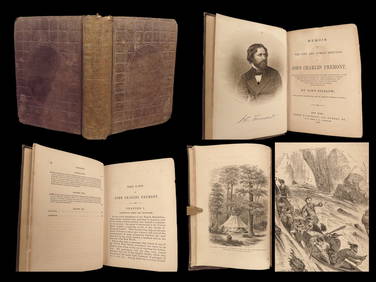
1856 CALIFORNIA 1st ed Memoir John C. Fremont Expeditions Oregon Trail IndiansSchilb Antiquarian Rare Books4.8(421)See Sold PriceMar 10, 2024
Al Barnes (1937-2015), A Meeting at the PointCopley Fine Art Auctions4.5(40)See Sold PriceFeb 24, 2024
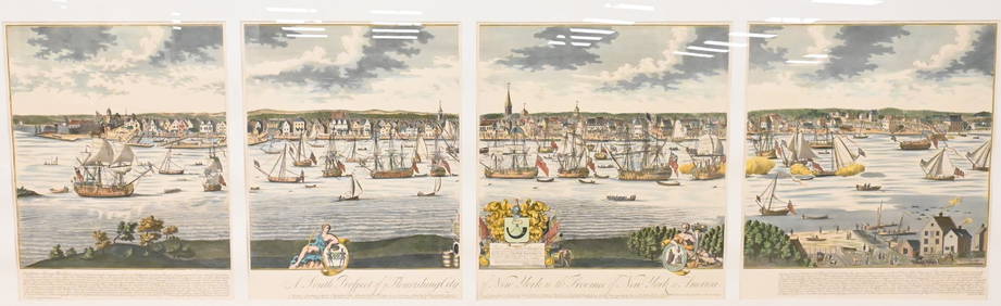
A South Prospect of Ye Flourishing City of New York in the Province of New York, North AmericaNadeau's Auction Gallery4.7(401)See Sold PriceFeb 24, 2024
Lladro Porcelain A WINTRY DAY Statue Model 3513Hill Auction Gallery 4.7(1k)See Sold PriceFeb 28, 2024
[LITHOGRAPHY]. [NATIVE AMERICANS]. Group of Five Hand-Color...Potter & Potter Auctions4.6(539)See Sold PriceMar 07, 2024
Lot of 20 1950s-1970s Various Sized Cap Guns, Holsters & 1 4pk Roll CapsJC Auctions4.4(47)See Sold PriceFeb 27, 2024
Carey, pub. 1796 - Map of the Tennassee State formerly part of North Carolina (Tennessee)Trillium Antique Prints & Rare Books4.5(30)See Sold PriceFeb 24, 2024
Mckenney & Hall - Two Octavo Volumes of Text with Rare Plate of Billy BowlegsTrillium Antique Prints & Rare Books4.5(30)See Sold PriceFeb 24, 2024
McKenney & Hall, Folio, Rare - 5 Native American LithographsTrillium Antique Prints & Rare Books4.5(30)See Sold PriceFeb 24, 2024
McKenney & Hall, Folio, Rare - Se-Quo-YahTrillium Antique Prints & Rare Books4.5(30)See Sold PriceFeb 24, 2024
McKenney & Hall, Folio, Rare - Hunting the BuffaloeTrillium Antique Prints & Rare Books4.5(30)See Sold PriceFeb 24, 2024
Audubon, Imperial Folio - Canada Lynx. 16Trillium Antique Prints & Rare Books4.5(30)See Sold PriceFeb 24, 2024
Karl Bodmer - Scalp Dance of the Minatarres. 27Trillium Antique Prints & Rare Books4.5(30)See Sold PriceFeb 24, 2024
1822 MAP of NORTH & SOUTH AMERICA GEOGRAPHICAL STATISTICAL HISTORICAL antiqueJasper524.5(9.8k)See Sold PriceFeb 28, 2024
VARIOUS ARTISTS [SANTA FE RAILROAD]. Group of 4 posters. Circa 1950s.Swann Auction Galleries4.4(65)See Sold PriceFeb 29, 2024
*SALE HIGHLIGHT* Wisconsin Winged Bannerstone- 2x COA-Dickey/Motley;Heartland Artifact Auctions Inc4.7(780)See Sold PriceMar 10, 2024
5 Inuit Stone Carvings - Animals, Boat, Head w/ FacesArtemis Fine Arts4.8(1.4k)See Sold PriceFeb 27, 2024
Herman Moll A New Map of Ye North Parts of AmericaWillow Auction House4.5(283)See Sold PriceMar 14, 2024


![[LITHOGRAPHY]. [NATIVE AMERICANS]. Group of Five Hand-Color... (1 of 5)](https://p1.liveauctioneers.com/928/318880/171361074_1_x.jpg?height=282&quality=70&version=1707501302)


![VARIOUS ARTISTS [SANTA FE RAILROAD]. Group of 4 posters. Circa 1950s. (1 of 1)](https://p1.liveauctioneers.com/199/319703/171640606_1_x.jpg?height=282&quality=70&version=1707943705)