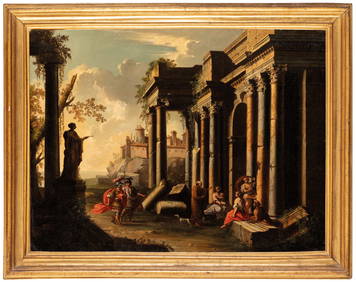
SoldSEUTTER (MATTHAEUS) - MAP ULMA MEMORABILIS AC PSEUTTER (MATTHAEUS) - MAP ULMA MEMORABILIS AC PERMUNITA LIBERA IMPERII CIVITAS AD DANUBIUM. Hand colored engraving, later printing (16' x 18.75"); Together with 5 assorted 20th Century maps of variousSee Sold Price
SoldAfter Matthaeus Seutter Map of North AmericaAfter Matthaeus Seutter (1678-1757) colored engraving map of North America. Dimensions: Sight; height: 18 1/2 in x width: 21 1/2 in. Framed; height: 25 1/4 in x width: 28 in. SKU: 03585See Sold Price
SoldAfter Matthaeus Seutter: Map of North America.After Matthaeus Seutter: Map of North America. Colored engraving Sight: 18" x 21"See Sold Price
Sold(MAP) SEUTTER, MATTHAEUS A group of two hand-colo(MAP) SEUTTER, MATTHAEUS A group of two hand-colored engraved maps. Augsburg: [c. 1740 or later.] America Meridionalis per sua Renga Province. Hand-colored engraved map of South America. Nova Orbis siSee Sold Price
SoldSeutter, Matthaeus, 1678-1756, 1744 Map: "Novus OrbisSeutter, Matthaeus, 1678-1756, 1744 Map: "Novus Orbis Sive America Meridionalis Et Septentrionalis : divisa per sua regna, provincias et insul: cura et opera. Matth. Seutt. S.C.M. Geogr. Aug. Vind.,,,See Sold Price
Soldc. 1744 ASIA Hand-Colored Map, Matthaeus SeutterHistoric Maps c. 1744 Hand-Colored Map of Asia by Matthaeus Seutter c. 1744, Hand-Colored Engraved Copper-Plate Map titled, “ASIA Cum omnibus Imperiis Provinciis Statibus et Insulis Correcta et adorSee Sold Price
3 Antique German Maps by Matthaeus Seutter & GuillaumeSeutter, Matthaeus, (German 1678-1756) Plan De Mayence et des Environs , De L'Isle, Guillaume Le cours du Rhin depuis Worms, jusqua Bonne, et les pays adjacens , Topographical Views of Treverts, CobolSee Sold Price
SoldMap of North America based on Matthaeus SeutterColored engraving map of North America based on the map by Matthaeus Seutter (1678-1757). Dimensions: Sight; height: 18 1/2 in x width: 21 1/2 in. Framed; height: 25 1/4 in x width: 28 in. SKU: 03585See Sold Price
SoldSeutter (Matthaeus) Imperium JaponicumSeutter (Matthaeus) Imperium Japonicum,inset map of Nagasaki, with decorative panels and scenes of Japanese life, engraved map with original hand-colouring, 480 x 580mm., split and rejoined alSee Sold Price
Sold[Seutter (M)] Statua Regum Europæorum[Seutter (Matthaeus)] Statua Regum Europæorum P.C.N. Nomina Continens,cartographic curiosity depicting a warrior king surrounded with regal trophies and coats-of-arms, the figure's breastplateSee Sold Price
Seutter (Matthaeus) Japonicum-. Seutter (Matthaeus) Imperium Japonicum, engraved map with full original hand-colouring, inset map of Nagasaki, decorative panels and scenes of Japanese life, 495 x 580mm., one or 2 short teSee Sold Price
Sold"Diversi Globi Terr-Aquei Statione Variante...""Diversi Globi Terr-Aquei Statione Variante..." engraved world map by Matthaeus Seutter [Augsburg, 1720s], showing west coast of Australia, Diemen's Land & California as an island, some minor faulSee Sold Price
SoldSEUTTER, MATTHAEUS. Asia.SEUTTER, MATTHAEUS. Asia. Double-page engraved map, 510x595 mm, ample margins; nicely hand-colored; entirely mounted to a stiff board. Augsburg, circa 1730 All items are offered for sale subject to SwSee Sold Price
Sold(Maps and Charts, Europe, Seutter, Matthaeus (1647(Maps and Charts, Europe, Seutter, Matthaeus (1647?1756)), Die Hochfurstliche Residentz Frieden und Hauptstadt Gotha, Augsburg, [c. 1730 or later], with contemporary hand-coloring, framed, 600 x 520 mSee Sold Price
Sold(Maps and Charts, Europe, Seutter, Matthaeus (1647(Maps and Charts, Europe, Seutter, Matthaeus (1647?1756)), Vienna, Metropolis Austriae Inferioris et celeberrima..., Augsburg, [c. 1730], with contemporary hand-coloring, framed, 590 x 520 mm, (minorSee Sold Price
[Seutter (Matthaeus)] Accurata Utopiæ Tabula[Seutter (Matthaeus)] Accurata Utopiæ Tabula,allegorical continental map including the kingdoms of Mammonia, Prodigalia, Stultorum and others, Respublica Venerea, Tobaco Ins[ula], and elsewherSee Sold Price
Sold[Seutter (Matthaeus)] Accurata Utopiæ Tabula[Seutter (Matthaeus)] Accurata Utopiæ Tabula,allegorical continental map including the kingdoms of Mammonia, Prodigalia, Stultorum and others, Respublica Venerea, Tobaco Ins[ula], and elsewherSee Sold Price
Map of London & vicinity c.1740Heading: (Map) Author: Seutter, Matthaus Title: Delineatio ac Finitima Regio Magnae Brittaniae Metropoleos Londini ad Novissimam Normam Place Published: Augsburg Publisher: Date Published: c.See Sold Price
Sold(Maps and Charts, Middle East),, Seutter, Matthaeu(Maps and Charts, Middle East),, Seutter, Matthaeus, Deserta Aegypti Theraidis Arabiae Syriae, etc, Augsburg, [1745], double page map with hand coloring, folio, 20 3/4 x 24 in., (minor color runs alonSee Sold Price
SoldGeorg Matthaeus Seutter, "Palatinatus Rheni". HandGeorg Matthaeus Seutter, "Palatinatus Rheni". Hand coloured map with inscription within left hand cartouche etc, "Palatinatus Inferior, Sive. Electoratus Palatinus Ad Rhenum cum adjacentibus, Archi EpSee Sold Price
SoldSeutter, Matthaeus187. Seutter, Matthaeus.Accurata delineatio et prospectus...Berolini. Large engraved map depicting a plan of the city of Berlin surrounded by various notable buildings. 46 x 21 inches, neatly matted,See Sold Price
SoldSeutter (Matthaeus) ParaquariaeSeutter (Matthaeus) Paraquariae Paraguay, ornamental cartouche (uncoloured), engraved map with original hand-colouring, 575 x 490mm., browning to central horizontal fold, Augsburg, [c.1740].See Sold Price
SoldKONVOLUT AUS SECHS GUCKKASTENBLAETTERN, STADTANSICHTEN UND LCOLLECTION OF SIX CITY VIEWS AND MAPS i.a. Johann Baptist Homann, Matthaeus Seutter, Gerard Valk, Bergmueller Engravings, colored, on paper. Min. sheet size 30.5 x 41 cm, max. sheet size 53.5 x 62 cm.See Sold Price
SoldSeutter (Matthaeus) - Londinum celeberrima Metropolisdetailed plan of London with large panorama below, title panel above, in Latin and German, royal arms upper left, engraved map with original hand-colouring, panorama uncoloured, 510 x 585mm., soft cenSee Sold Price
Ohio and Pennsylvania RR 2nd Annual Report-March 4, 1850JM Hobby Supply and Railroad Artifact Auctions4.4(127)See Sold PriceFeb 24, 2024
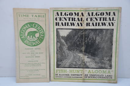
Algoma Central RY March 12, 1944 Public Timetable and BrochureJM Hobby Supply and Railroad Artifact Auctions4.4(127)See Sold PriceFeb 24, 2024
LARGE LATE 17TH C. DUTCH CHART OF CANADA, GREAT LAKES, NEW FRANCE, LABRADOR, HUDSON BAY, BY PIERREThomaston Place Auction Galleries4.4(393)See Sold PriceFeb 24, 2024
EARLY 18TH C. DUTCH CHART OF PACIFIC OCEAN BY FREDERIK DE WIT (1629-1706) WITH CALIFORNIA AS ANThomaston Place Auction Galleries4.4(393)See Sold PriceFeb 24, 2024
17TH C. MAP OF THE BERKSHIRES BY JOHN SPEED, FRAMEDThomaston Place Auction Galleries4.4(393)See Sold PriceFeb 24, 2024
Nova Totius Full Color Geographical World MapThe Benefit Shop Foundation Inc.4.3(2.9k)See Sold PriceFeb 28, 2024
1855 Guide for the Pennsylvania Railroad with an Extensive Map from the Pennsylvania RailroadRail & Road Auctions4.6(165)See Sold PriceMar 07, 2024
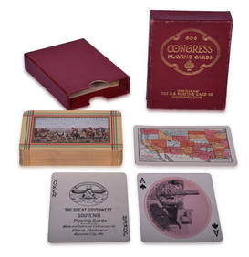
Fred Harvey Railroad Early Souvenir Playing Cards of the Great Southwest - Indians and Train SmokeRail & Road Auctions4.6(165)See Sold PriceMar 08, 2024
18th Century Hess Germany Hand colored Engraved MapGlobal Auctions Company4.3(36)See Sold PriceMar 03, 2024
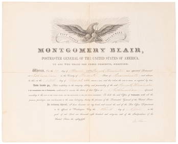
SOMERSET, Lord Charles (1767-1831) and BLAIR, Montgomery (1...Potter & Potter Auctions4.6(545)See Sold PriceMar 07, 2024
[CIGARETTE CARDS]. A Group of Various Cigarette Cards of Ac...Potter & Potter Auctions4.6(545)See Sold PriceMar 07, 2024
1722 POMPONII MELA De Situ Orbis ARMORIAL VELLUM BINDING antiqueJasper524.5(9.9k)See Sold PriceFeb 27, 2024
1800 MUNGO PARK TRAVELS to AFRICA 2 VOLS w/ MAP antique in ENGLISHJasper524.5(9.9k)See Sold PriceFeb 27, 2024
3 Vintage The World Lithographs, By JanssonThe Benefit Shop Foundation Inc.4.3(2.9k)See Sold PriceMar 13, 2024


![[Seutter (M)] Statua Regum Europæorum (1 of 1)](https://p1.liveauctioneers.com/410/14124/4342282_1_x.jpg?height=282&quality=70&version=1192724045)


![[Seutter (Matthaeus)] Accurata Utopiæ Tabula (1 of 1)](https://p1.liveauctioneers.com/410/27204/10275929_1_x.jpg?height=282&quality=70&version=1320753154)
![[Seutter (Matthaeus)] Accurata Utopiæ Tabula (1 of 1)](https://p1.liveauctioneers.com/410/28793/11078142_1_x.jpg?height=282&quality=70&version=1331114477)


![[CIGARETTE CARDS]. A Group of Various Cigarette Cards of Ac... (1 of 1)](https://p1.liveauctioneers.com/928/318880/171361511_1_x.jpg?height=282&quality=70&version=1707501302)