1952 ROBERT F. KENNEDY HANDWRITTEN LETTERJohn McInnis Auctioneers,LLC4.5(505)See Sold PriceFeb 25, 2024
CASED PRESENTATION HALF HULL MODEL OF THE BARQUE "HAWTHORNBANK" Last Quarter of the 19th CenturyEldred's4.7(419)See Sold PriceFeb 27, 2024
Lot Of 14 Jack Daniels And Country Club Glass Spirit BottlesRbfinearts4.5(578)See Sold PriceFeb 24, 2024
PR OF 17TH C. SPANISH BRASS CANDLESTICKSThomaston Place Auction Galleries4.4(393)See Sold PriceFeb 24, 2024
Lake Shore and Michigan Southern RR Special Excursions Timetable-July 7-13, 1892JM Hobby Supply and Railroad Artifact Auctions4.4(127)See Sold PriceFeb 24, 2024
Tiffany & Co. Sterling Silver Corkscrew Bottle OpenerSJ Auctioneers4.5(167)See Sold PriceMar 03, 2024
SoldSeale (R. W.) Map of Principality of MaltaSeale (Richard William) A New Map & Land Chart of the Sovereign Principality of Malta,Malta and Gozo with large pictorial title cartouche depicting a knight of Malta reaching for a sinking shiSee Sold Price
SoldSeale (R. W.) Islands of Malta and Goza-. Seale (Richard William) engraver An Accurate Map of the Islands of Malta and Goza; An exact Plan of the Capital City and Port of Malta, together 2 engraved maps of Malta and Valetta, with hSee Sold Price
SoldSeale (R.W.) Map of the County of MiddlesexSeale (Richard William) Map of the County of Middlesex,from North Mimms to Thames Ditton, and from Langley to Leytonstone, the map flanked by panels of the arms of all the Free Companies of LoSee Sold Price
SoldSEALE, R. W. A Map of North America with the European SSEALE, R. W. A Map of North America, With the European settlements & whatever else is remarkable in ye West Indies, from the latest and best Observations. [London, 1745]. Engraved map of North AmericaSee Sold Price
SoldSEALE, R.W. "A Map of North America with theEuropean Settlements & whatever else is remarkable in ye West Indies, from the latest and best observations" engraving, C. 1745. From a Scarsdale, NY collector. Particularly notable for displaying CalSee Sold Price
SoldA Map of South America 1750MAP - SEALE, R.W. A Map of South America with all the European Sttlements.[London: c.1750]. Engraved map (sheet size: 516x420 mm). Condition: old folds, right margin close-shaved with small teSee Sold Price
SoldR.W. Seale, Map of North America, 1745"A Map of North America with the European Settlements & Whatever Else Is Remarkable in ye West Indies, from the Latest and Best Observations" drawn and engraved by Richard William Seale, London, 1745.See Sold Price
SoldR. W. Seale,R. W. Seale, Map of the County of Middlesex, hand coloured engraving c.1760, for Bowles and Sayer, 53 x 73cm (visible)See Sold Price
SoldAntique map, "A Map of South America with all theAntique map, "A Map of South America with all the European Settlements & whatever else is remarkable from the latest & best observations", R.W. Seale, map is 18.5" by 14.75". Notice: Please note thatSee Sold Price
SoldMap of London 1736Heading: Author: Seale, R.W., engraver Title: A Pocket Map of London, Westminster and Southwark, With ye New Buildings to ye Year 1736 Place Published: London Publisher:Sold by I. Fentum Date PuSee Sold Price
Map of London 1736Heading: Author: Seale, R.W., engraver Title: A Pocket Map of London, Westminster and Southwark, With ye New Buildings to ye Year 1736 Place Published: London Publisher:Sold by I. Fentum Date PuSee Sold Price
SoldNorth America Map with Calif. an IslandHeading: (North America) Author: Seale, R[ichard] W[illiam] Title: A Map of North America with the European Settlements & whatever else is remarkable in ye West Indies, from the latest and best ObservSee Sold Price
SoldSeale map of North America California an islandHeading: Author: Seale, R[ichard] W[illiam] Title: A Map of North America with the European Settlements & whatever else is remarkable in ye West Indies, from the latest and best Observations Place PuSee Sold Price
SoldRapin's Chart of St. George's ChannelRapin De Thoyras (Paul) A Correct Chart of St. George's Channel and the Irish Sea,Ireland and the west coast of the British Isles, decorative title cartouche, engraved map by R. W. Seale, 470See Sold Price
SoldR W SEALE & W H TOMS BOOK OF 33 EARLY MAPSNICE EARLY BOOK, MISSING ONE COVER BOARD OF 33 EARLY MAPS. SOME HAVE R W SEALE AND A FEW WITH W H TOMS. THE CONTENTS PAGE IS INTACT. CAN'T SEE A DATE, PROBABLY EARLY TO MID 1700'S.WHEN OPENED, PAGES MSee Sold Price
Atlas of Ancient Geography c.1750Heading: Author: Seale, Richard William & William Henry Toms Title: Atlas of ancient geography with 33 maps engraved by R.W. Seale or W.H. Toms Place Published: No place Publisher: Date PublisheSee Sold Price
SoldSeale (R. W.) County of MiddlesexSeale (Richard William) Map of the County of Middlesex,from North Mimms to Thames Ditton, and from Langley to Leytonstone, the map flanked by panels of the arms of all the Free Companies of LoSee Sold Price
Sold*SEALE, R.W.(19th C. European) Map of Italy and surrounding nations, framed handcolored engraving, bears artist name in plate lower right, approximate plate size 15" x 18 1/2", frame 22" x 27".See Sold Price
SoldRicahrd Seale's A New and Accurate Map of NorthRicahrd Seale's A New and Accurate Map of North America......drawn by the famous Mr. D'Annville with Improvements from the Best English Maps; and Engraved by R. W. Seale; Also the New Divisions accordSee Sold Price
SoldBooks Framed Rapin's History Map of Ireland1759 AD. A printed map of Ireland designed by R.W. Seale with the legend A Map of the Kingdom of Ireland from ye latest & best Observations. For Mr. Tindal's Continuation of Mr. Rapin's History; mountSee Sold Price
SoldSeale map of North America California an islandTitle: A Map of North America with the European Settlements & whatever else is remarkable in ye West Indies, from the latest and best Observations Author: Seale, R[ichard] W[illiam] Description: CoppeSee Sold Price
SoldTwo maps of North America by R.W. Seale publishedby University Magazine. North America- Site: 10.75"H x 14"W; Frame: 17.5"H 21.25"W; Canada- Site: 10.5"H x 13.75"W; Frame: 17.5"H x 21.25"W. Circa - Late 19th C.See Sold Price
Sold1740 America Map Showing California As An IslandHistoric Maps c. 1740 Beautiful Map Showing California As An Island! A MAP OF NORTH AMERICA... by R.W. Seale, London c. 1740, Historic Hand-Colored Map titled, “A MAP OF NORTH AMERICA WITH THE EUROPSee Sold Price
SoldR. W. SEALE A Correct Chart of St. George’s Channel andA Correct Chart of St. George's Channel and the Irish Sea [1743] , Handcoloured map (39 cm. wide; 49.5 cm. high) in outline with cartouche. From Mr. Tindal's Continuation of Mr Rapin's History of EnglSee Sold Price
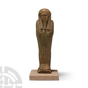
Egyptian Faience Shabti Figure with Hieroglyphic InscriptionTimeLine Auctions Ltd.4.6(183)See Sold PriceMar 06, 2024
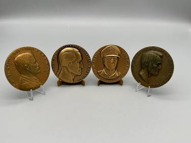
4/5 R.W. Julian's Satirical Bronze Medals 1977-1981Dana J. Tharp Auctions4.7(271)See Sold PriceFeb 24, 2024
Columbus and Greenville Railroad Mississippi Round Brass Wax Sealer - Purchasing AgentRail & Road Auctions4.6(165)See Sold PriceMar 08, 2024
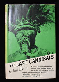
THE LAST CANNIBALS by JENS BJERRE 1957 Fine or Near FineNorth American Artifact Auctions4.7(198)See Sold PriceApr 20, 2024
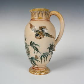
Rare Martin Brothers RW Wallace Stoneware Bird PitcherLion and Unicorn4.8(1.9k)See Sold PriceFeb 25, 2024
Albin - Bald or Vulturine Eagle. 2-3Trillium Antique Prints & Rare Books4.5(32)See Sold PriceFeb 24, 2024
Albin - King Vulture or Warwounen. 2-4Trillium Antique Prints & Rare Books4.5(32)See Sold PriceFeb 24, 2024
1738 RUSSIA SIBERIA & GREAT TARTARY Description illustrated ANTIQUE in ENGLISHJasper524.5(9.9k)See Sold PriceFeb 27, 2024
Birmingham.- Commercial map.- Smith (J. Pigott) To the Right Honourable William Earl of Dartmouth...Forum Auctions4.3(53)See Sold PriceFeb 29, 2024