SoldSAYER and BENNETT. Chart, containing the CoastSAYER and BENNETT. Chart, containing the Coasts of California, New Albion, and Russian Discoveries to the North [etc.] / North America and the West Indies. Engraved two-sheet folding map joined, 460x1See Sold Price
SoldSayer & Bennett N. America MapRobert Sayer, English, 1725-1794, and John Bennett, English, fl. 1770-1784. Engraved map with hand colored outline is fully titled "Chart containing the Coasts of California, New Albion, and Russian DSee Sold Price
SoldSayer (Robert) Lands End and Scilly IslesSayer (Robert) and John Bennett. A Chart of the Entrance into the Channel, Containing the West Coast Coast of Cornwall, and Scilly Islands, with all the Soundings,detailed chart with extensiveSee Sold Price
Sold[MAP]. SAYER. Coasts of California.... London, 1775369. [MAP]. SAYER, R[obert] & J[ohn] Bennett (publishers) & [Thomas Jefferys (engraver)]. [Title on left sheet] Chart, containing the Coasts of California, New Albion, and Russian DiscoveriesSee Sold Price
Chart of Coast of Guiana 1781Title: A New Chart of Coast of Guayana from Rio Orinoco to River Berbice, Containing the Dutch Colonies of Poumaron, Issequibo and Demerary, and Berbice Author: Sayer & Bennett Description: Copper-engSee Sold Price
Chart of Coast of Guiana 1781Title: A New Chart of Coast of Guayana from Rio Orinoco to River Berbice, Containing the Dutch Colonies of Poumaron, Issequibo and Demerary, and Berbice Author: Sayer & Bennett Description: Copper-engSee Sold Price
SoldSayer (R) Cornwall, Scily Islands chartSayer (Robert) A Chart Of The Entrance Into The Channel Containing the West Coast of Cornwall, and Scilly Islands, with all the Soundings, showing the Scilly Isles and the Cornwall peninsula fSee Sold Price
SoldLAURIE & WHITTLE. Chart containing the CoastsLAURIE & WHITTLE. Chart containing the Coasts of California, New Albion [etc.] / North America and the West Indies. Together, 2 engraved folding maps joined, issued separately but intended to be joineSee Sold Price
SoldMAP - Gulf of St. Lawrence, Canada. JefferysGulf of St. Lawrence, Canada. Jefferys/Sayer & Bennett, A Chart of the Gulf of St. Laurence, Composed from a Great Number of Actual Surveys and Other Materials, Regulated and Connected by AstronomicalSee Sold Price
SoldNorth America with Pacific & Atlantic 1775Title: Chart, Containing the Coasts of California, New Albion, and Russian Discoveries to the North; with the Peninsula of Kamtschatka, in Asia, Opposite thereto / North America and the West Indies, wSee Sold Price
SoldSAYER and BENNETT. A Chart of North and SouthSAYER and BENNETT. A Chart of North and South America. Large engraved 6-sheet map joined as 3, 1380x1125 mm overall, ample margins; hand-colored in outline; some minor abrading along centerfold, scattSee Sold Price
Sold(Maps and Charts, America), Sayer, Robert & Bennet(Maps and Charts, America), Sayer, Robert & Bennett, John, A Map of Pennsylvania...from the late Map of W. Scull Published in 1770, London, 1775, hand-colored, three sheets joined, framed, sight sizeSee Sold Price
SoldSayer (Robert) and John Bennett. Publishers. A GenSayer (Robert) and John Bennett. Publishers. A General Chart of the China Sea,Drawn from the Journals of the European Navigators particularly from those Collected by Capt. Hayter, from 'The OrSee Sold Price
Sold(Maps and Charts, North America), Sayer, Robert &(Maps and Charts, North America), Sayer, Robert & Bennett, Jonathon, A General Map of the Northern British Colonies in America. which Comprehends The Province of Quebec, The Government of NewfoundlandSee Sold Price
SoldFirst state of this handsome sailing chart of The GulfA Chart of the Gulf of St. Laurence...Thomas Jefferys (c. 1719 – 1771). Copperplate engraved map. London: Sayer & Bennett, 1775. 21 1/2 x 29 inches sheet. First state of this handsome sailing chartSee Sold Price
SoldFirst English edition of Muller's map of the NW CoastThe Russian Discoveries, from the map published by the Imperial Academy of St. Petersburg. Thomas Jefferys (c. 1719 – 1771). Copperplate engraved map. London: Sayer & Bennett, 1775. 21 1/2 x 29 inchSee Sold Price
SoldSayer & Bennett New York MapSAYER, Robert (ca. 1724-1794) & BENNETT, John (fl. 1760-d.1787). Chart of the Entrance of Hudson's River, from Sandy Hook to New York, with the Banks, Depths of Water, sailing marks... Engraved map. LSee Sold Price
SoldSayer & Bennett Detailed map of New YorkSAYER, Robert (ca. 1724-1794) & BENNETT, John (fl. 1760-d.1787). Chart of the Entrance of Hudson's River, from Sandy Hook to New York... Engraved map. London: Sayer & Bennet, 1776. 29 1/2" x 21 1/2" sSee Sold Price
SoldJefferys' 18th Century Map of the Banks of NewfoundlandA chart of the Banks of Newfoundland... Drawn from Chabert, Cook and Flerieu...Thomas Jefferys (c. 1719 – 1771). Copperplate engraved map handcolored in outline. London: Sayer & Bennett, March, 1775See Sold Price
SoldJefferys' 18th Century Map of the Island ofA General chart of the Island of Newfoundland... Thomas Jefferys (c. 1719 – 1771). Copperplate engraved map handcolored in outline. London: Sayer & Bennett, 1776. 21 1/2 x 29 inches sheet. ImportantSee Sold Price
Sold18th-Century Engraved Maps - Canadian Su18th-Century Engraved Maps - Canadian Subjects: [Jeffreys, Thomas.] "A Chart of the Gulf of St. Lawrence." London: Sayer & Bennett, 1775. 25 x 20 1/4 inches; 635 x 514 mm. Margins. Out-line color. CreSee Sold Price
SoldA General Chart of the Island of Newfoundland.Capt. James Cook and Michael Lane. engraved map with original hand-color in part. London: Thomas Jefferys for Robert Sayer & J Bennett, 1775. 22 1/4 x 24 1/2 inches, 27 1/4 x 29 1/2 inches framed. A DSee Sold Price
SoldChart of the Entrance of Hudson's River. [1776].[New York]. CHART OF THE ENTRANCE OF HUDSON’S RIVER, FROM Sandy Hook to New York, with the Banks Depths of Water, Sailing-marks &ca. Lon: Robert Sayer & John Bennett, 1776. 27 5/8” x 20 ½”. DetSee Sold Price
Sayer and Bennett Map of No. America and West IndiArtist:R. Sayer and J. Bennett No. 53 Fleet Street Title:Map of The Coasts of California, New Albion, and Russian Discoveries to the North [etc.] / North America and the West Indies Date:1775, PublishSee Sold Price
LATE 18TH C. VERY LARGE CHART OF NORTHEAST CANADA BY DES BARRES (1721-1824), 1780, FRAMEDThomaston Place Auction Galleries4.4(393)See Sold PriceFeb 24, 2024
CHART "SOUTHERN COAST OF LONG ISLAND FROM MONTAUK POINT TO EAST HAMPTON" Circa 1877 11.25" x 22.75"Eldred's4.7(419)See Sold PriceFeb 27, 2024
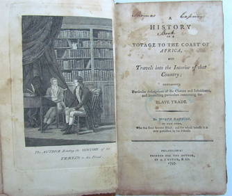
1797 HISTORY OF VOYAGE TO COAST of AFRICA by JOSEPH HAWKINS antique 1st EDITIONJasper524.5(9.9k)See Sold PriceFeb 27, 2024
1816 MAP NORTHERN PART OF RUSSIA or MUSCOVY in EUROPE copper engraving ANTIQUEJasper524.5(9.9k)See Sold PriceFeb 27, 2024
West Indies. South Coast of Jamaica from Port Royal to Pedro Bluff.Jasper524.5(9.9k)See Sold PriceFeb 27, 2024
West coast of Africa from Cape Blanco… Arguin bay, Mauritania. LABAT 1745 mapJasper524.5(9.9k)See Sold PriceFeb 28, 2024
Carte de la Guinée, contenant…'. Guinea & Cape Verde islands. BONNE 1771 mapJasper524.5(9.9k)See Sold PriceFeb 28, 2024
South Namibia coast. Walvis Bay-Orange River ADMIRALTY sea chart 1881 (1954) mapJasper524.5(9.9k)See Sold PriceFeb 28, 2024
East coast of Africa from the Cape… South Africa Mozambique. CHILD 1745 mapJasper524.5(9.9k)See Sold PriceFeb 28, 2024
Western coast of Africa… to the River Sanaga. Southern Mauritania LABAT 1745 mapJasper524.5(9.9k)See Sold PriceFeb 28, 2024
CHARTS: United States - East Coast New Jersey/ PASSAIC AND HACKENSACK RIVERSChurchill Galleries3.7(217)See Sold PriceFeb 26, 2024
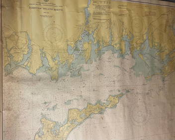
CHART: UNITED STATES - EAST COAST/ RHODE ISLAND - CONNECTICUT - NEW YORK/ Fishers IslandChurchill Galleries3.7(217)See Sold PriceFeb 26, 2024
CHART: UNITED STATES - EAST COAST MASSACHUSETTS/ HYANNIS HARBORAND VICINITYChurchill Galleries3.7(217)See Sold PriceFeb 26, 2024
Chart: United States- East Coast/ NORTH CAROLINA/ RIVER INLET TO CAPE FEAR.Churchill Galleries3.7(217)See Sold PriceFeb 26, 2024
CHART: UNITED STATES - EAST COAST NEW YORK/ HUDSON RIVER/ POUGHKEEPSIE TO HUDSONChurchill Galleries3.7(217)See Sold PriceFeb 26, 2024
Bennett Bradbury (Untitled - Seascape) Signed Original OilMichael's Gallery4.6(94)See Sold PriceFeb 24, 2024


![[MAP]. SAYER. Coasts of California.... London, 1775 (1 of 4)](https://p1.liveauctioneers.com/514/38482/16500438_1_x.jpg?height=282&quality=70&version=1363615005)


![Chart of the Entrance of Hudson's River. [1776]. (1 of 3)](https://p1.liveauctioneers.com/179/64124/32202587_1_x.jpg?height=282&quality=70&version=1416275428)