Gothic Revival Stained Glass Window of The ResurrectionSchmidt's Antiques Inc. Since 19114.8(431)See Sold PriceMar 02, 2024
THE FITZGERALD FAMILY TEA and DINNER SERVICEJohn McInnis Auctioneers,LLC4.5(505)See Sold PriceFeb 25, 2024
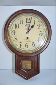
Union Pacific RR Cheyenne, WY Locomotive Shop ClockJM Hobby Supply and Railroad Artifact Auctions4.4(127)See Sold PriceFeb 24, 2024
A CHINESE PORCELAIN GREEN ENAMELED DRAGON MOON FLASK BIANHUBerkeley Auction Gallery4.4(16)See Sold PriceMar 03, 2024
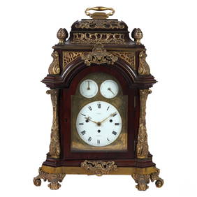
Antique George III Musical Bracket Clock by Hare LondonHill Auction Gallery 4.7(1k)See Sold PriceFeb 28, 2024
No Reserve Early 20th century French / Flemish Design Tapestry 6 ft 2 in x 4 ft 9 in (1.87 m x 1.44Nazmiyal Auctions4.4(34)See Sold PriceFeb 25, 2024
Central Anatolia Konya Antique Rug 4 ft 8 in x 3 ft 8 in (1.42 m x 1.11 m)Nazmiyal Auctions4.4(34)See Sold PriceFeb 25, 2024
PAIR MAGNIFICENT AND LARGE CLOISONNE ENAMEL CRANES INCENSE BURNERSBerkeley Auction Gallery4.4(16)See Sold PriceMar 03, 2024
From Davide Halevim Collection Antique Persian Mohtashem Kashan Rug 10'11" x 7'10" (3.32 m x 2.38 m)Nazmiyal Auctions4.4(34)See Sold PriceFeb 25, 2024
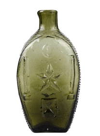
RARE COVENTRY GLASS WORKS MASONIC FLASKJohn McInnis Auctioneers,LLC4.5(505)See Sold PriceFeb 25, 2024
Empire by Buccellati Italy Sterling Silver Flatware Set 99 pieces DinnerBidhaus4.3(762)See Sold PriceFeb 25, 2024
S. Mitchell: Map of West Indies, 1846Map: West Indies Maker: H.n. Burroughs, Tanner, Henry Schenk/Aamuel Augustus Mitchell Size: Quarto - 10.60 H x 14.50 W Inches Published: Philadelphia, 1846 Attractive copprplate map with notes upper rSee Sold Price
SAMUEL AUGUSTUS MITCHELL - WEST INDIES, 1846Samuel Augustus Mitchell - West Indies, 1846 - 30 X 24 3/8 In. - This Giclée Print Is Gallery Stretched And Ready To Hang Or Lean Against A Wall, Or Display On An Easel. - A Giclée Print Is The HighSee Sold Price
SAMUEL AUGUSTUS MITCHELL - WEST INDIES, 1846 -Samuel Augustus Mitchell - West Indies, 1846 - Giclée On Canvas - 30 X 24 3/8 In. - A Giclée Print Is The Highest Quality Print Available Today. Because There Is No Visible Dot Screen Pattern, The RSee Sold Price
Scarce and lovely 1848 Mitchell map of West IndiesOriginal antique map of the Caribbean Islands from the scarce Mitchell's Universal Atlas of 1848. Exhibits lovely full hand coloring done at the time of publishing. Light tanning at extreme edges. TwoSee Sold Price
Mitchell, Map of the West, 1846A New Map of Texas, Oregon, and California, with the Regions Adjoining. Samuel Augustus Mitchell (1792-1868). Philadelphia: S. Augustus Mitchell, 1846. - Accompaniment to Mitchell's New Map of Texas,See Sold Price
1850 West Indies from Mitchell atlasA fine example of Thomas Cowperthwait and S. A. Mitchell's 1854 map of West Indies. Covers from Florida and the Bahamas south through the Caribbean islands of Cuba and Hispaniola (Haiti & the DominicaSee Sold Price
1850 West Indies from Mitchell atlasA fine example of Thomas Cowperthwait and S. A. Mitchell's 1854 map of West Indies. Covers from Florida and the Bahamas south through the Caribbean islands of Cuba and Hispaniola (Haiti & the DominicaSee Sold Price
SDUK: Map of British West Indies Islands, 1846Title/Content of Map: 'THE BRITISH ISLANDS IN THE WEST INDIES; Jamaica, Trinidad, Virgin Islands, Leeward Islands (St Christopher, Nevis, Barbuda, Antigua), St Lucie, St Vincent, Barbadoes, Tobago, DoSee Sold Price
SDUK: Antique Map of the West Indies Islands, 1846Title/Content of Map: 'THE BRITISH ISLANDS IN THE WEST INDIES; Jamaica, Trinidad, Virgin Islands, Leeward Islands (St Christopher, Nevis, Barbuda, Antigua), St Lucie, St Vincent, Barbadoes, Tobago, DoSee Sold Price
Mitchell: Map of Mexico, Central America, West IndiesMap: Map of Mexico, Central America, and the West Indies Cartographer: S. A. Mitchell Place & Date: Philadelphia / 1870 Size: 21 1/4" x 13 1/8" The beautifully detailed and colored map of the southernSee Sold Price
SoldMitchell: Map of Mexico, Central America & West IndiesItem: Map of Mexico, Central America, and the West Indies Maker: Samuel Augustus Mitchell Jr. Size: 21 x 13 Date: 1860 Samuel Augustus Mitchell (1790-1860) was an American geographer born in ConnectiSee Sold Price
SoldWest Indies.Title/Content of Map: West Indies. Date: 1847 Cartographer: MITCHELL, SAMUEL AUGUSTUS Publisher: S. AUG. MITCHELL Size: 12.1Height - 15Width Excellent pastel coloring. Margins browned. Few spots. ReseSee Sold Price
SoldMap of Mexico, Central America, and the West IndieSamuel Augustus Mitchell, Map of Mexico, Central America, and the West Indies. [with insets:] Map of the Island of Cuba [and] Map of the Island of Jamaica, lithograph (hand colored), 1860, 21 x 13 21See Sold Price
A. MITCHELL - Map of Mexico, Central American and theA. MITCHELL Map of Mexico, Central American and the West Indies. Hand-colored lithoengraving. 1867. 13-1/4 x 21-1/8 inches.See Sold Price
SoldMitchell: Map of the Caribbean & Mexico, 18671867 Mitchell Map of the Caribbean and Mexico -- Map of Mexico Central America and the West Indies, S. Mitchell 1867, Philadelphia, 13.1 x 21 in. A highly detailed map of Mexico, Central America and tSee Sold Price
Sold1860 Mitchell Mexico, Central America & West Indies Map1860 Map of Mexico, Central America and the West Indies, S. Augustus Mitchell. 13.25 x 21.13 inches. Authentic hand-colored antique map from Mitchell’s 1862 New General Atlas depicts Mexico, CentralSee Sold Price
SoldMitchell: Mexico, Central America, & West Indies MapMexico, Central America, and the West Indies, 23.75 x 15.25 in, 1877, S. Augustus Mitchell Please note that this lot has a confidential reserve. When you leave a bid in advance of the auction, submitSee Sold Price
Sold1876 Mitchell Map of the Caribbean and [verso] SouthTitle/Content of Map: 1876 Mitchell Map of the Caribbean and [verso] South America -- XXI Map of the West Indies [verso] XXIV South America Date: 1876, PhiladelphiaCartographer: S Mitchell Size: 8 X 1See Sold Price
Sold1876 Mitchell Map of Mexico, Caribbean and HawaiiTitle/Content of Map: 1876 Mitchell Map of Mexico, Caribbean and Hawaii [verso] Cuba [verso] Alaska -- Map of Mexico, Central America and the West Indies [verso] Cuba [verso] North Western America ShoSee Sold Price
Sold1869 Mitchell Map of the Carribean [verso] SouthTitle: 1869 Mitchell Map of the Carribean [verso] South America -- XXI Map of the West Indies [verso] XXIV South America Cartographer: S Mithchell Year / Place: 1869, Philadelphia Map Dimension (in.):See Sold Price
1876 Mitchell Map of the Caribbean and [verso] SouthTitle/Content of Map: 1876 Mitchell Map of the Caribbean and [verso] South America -- XXI Map of the West Indies [verso] XXIV South America Date: 1876, Philadelphia Cartographer: S Mitchell Size: 8 XSee Sold Price
1876 Mitchell Map of the Caribbean and [verso] SouthTitle/Content of Map: 1876 Mitchell Map of the Caribbean and [verso] South America -- XXI Map of the West Indies [verso] XXIV South America Date: 1876, Philadelphia Cartographer: S Mitchell Size: 8 XSee Sold Price
1858 Mitchell Map of Mexico, the Caribbean and CentralTitle: 1858 Mitchell Map of Mexico, the Caribbean and Central America -- No. 16 Map of Mexico, Central America and the West Indies Date: 1858, Philadelphia Cartographer: S Mitchell Size: 8 x 10.4 in.See Sold Price
1876 Mitchell Map of Mexico, Caribbean and HawaiiTitle/Content of Map: 1876 Mitchell Map of Mexico, Caribbean and Hawaii [verso] Cuba [verso] Alaska -- Map of Mexico, Central America and the West Indies [verso] Cuba [verso] North Western America ShoSee Sold Price
Carey, pub. 1796 - A Chart of the West IndiesTrillium Antique Prints & Rare Books4.5(32)See Sold PriceFeb 24, 2024
Carey, pub. 1796 - Map of the State of MarylandTrillium Antique Prints & Rare Books4.5(32)See Sold PriceFeb 24, 2024
Carey, pub. 1796 - Map of GeorgiaTrillium Antique Prints & Rare Books4.5(32)See Sold PriceFeb 24, 2024
Carey, pub. 1796 - Map of The State of South CarolinaTrillium Antique Prints & Rare Books4.5(32)See Sold PriceFeb 24, 2024
Carey, pub. 1796 - Map of KentuckyTrillium Antique Prints & Rare Books4.5(32)See Sold PriceFeb 24, 2024
Carey, pub. 1796 - Map of the Tennassee State formerly part of North Carolina (Tennessee)Trillium Antique Prints & Rare Books4.5(32)See Sold PriceFeb 24, 2024
Map of Part of the West Indies, Etc., Showing the Exact Position Of The U.S. War Steamer SanJasper524.5(9.9k)See Sold PriceFeb 27, 2024
West Indies. Rand, McNally & Co.'S Indexed Atlas Map of the West Indies.Jasper524.5(9.9k)See Sold PriceFeb 27, 2024
Geographical, Statistical, and Historical Map of the West Indies.Jasper524.5(9.9k)See Sold PriceFeb 27, 2024
OLD MAP of the West Indies/ Carta Esperica/ 1804Churchill Galleries3.7(217)See Sold PriceFeb 26, 2024
Cooke, George 1801 Antique Map. West Indies CaribbeanAlbion Auctions4.6(341)See Sold PriceMar 01, 2024
Framed Tropical West Indies Map PrintRapid Estate Liquidators and Auction Gallery4.5(1.1k)See Sold PriceFeb 26, 2024


![1876 Mitchell Map of the Caribbean and [verso] South (1 of 2)](https://p1.liveauctioneers.com/5584/153142/77325878_1_x.jpg?height=282&quality=70&version=1572400045)

![1869 Mitchell Map of the Carribean [verso] South (1 of 2)](https://p1.liveauctioneers.com/5584/194427/98040491_1_x.jpg?height=282&quality=70&version=1613575397)
![1876 Mitchell Map of the Caribbean and [verso] South (1 of 2)](https://p1.liveauctioneers.com/5584/144578/73088309_1_x.jpg?height=282&quality=70&version=1561513819)
![1876 Mitchell Map of the Caribbean and [verso] South (1 of 2)](https://p1.liveauctioneers.com/5584/148048/74811425_1_x.jpg?height=282&quality=70&version=1566334427)


