Soldmaps, Mitchell, 19th cent, state, world(lot of 10) Unframed handcolored lithographed maps, Various Countries and American States, c. 1881, by William H. Gamble and Samuel Augustus Mitchell, largest overall: 15.125''h x 23''wSee Sold Price
SoldMAPS, MITCHELL "PLAN OF NEW ORLEANS", ARKANSASUnframed map by Samuel Augustus Mitchell, Jr., copyright 1882, depicting "Plan of New Orleans, "Country Map of Florida" on one side, "County Map of the States of Arkansas, Mississippi and Louisiana" oSee Sold Price
SoldMAPS: MITCHELL NEW ORLEANS, FLORIDA, ARKANSASUnframed map, Samuel Augustus Mitchell, Jr., copyright 1882, depicting "Plan of New Orleans, "Country Map of Florida" on one side, "County Map of the States of Arkansas, Mississippi and Louisiana" onSee Sold Price
Sold19th C Hand Colored Map of State of Maine FRAMEDPublished by S.Augustus Mitchell, Jr. having a published date year of 1860. This hand colored map contains maps of the various countries of the world and plans of cities. Inset at lower right featuresSee Sold Price
SoldMitchell's 1865 New General Atlas BookUNITED STATES, 1865 An 1865 New General Atlas book by S. Augustus Mitchell, Jr. The book contains "Maps of the Various Countries of the World, Plans of Cities, Etc. Embraced in Fifty-Five Quatro Maps,See Sold Price
SoldSamuel Augustus Mitchell (1790-1868), "Map of the StateSamuel Augustus Mitchell (1790-1868), "Map of the State of Texas," 1852, No. 13, hand colored, H. -9 in., W. - 15 3/8 in.See Sold Price
SoldArkansas, Mississippi & Louisiana, 1872A beautiful example of the legendary American map publisher Samuel Augustus Mitchell Jr.'s 1872 map of the states of Louisiana, Mississippi and Arkansas. Covers the states of Mississippi, Louisiana anSee Sold Price
SoldSamuel Augustus Mitchell (1790-1868), "County Map ofSamuel Augustus Mitchell (1790-1868), "County Map of the States of Georgia and Alabama," 1860, H.- 12 1/4 in., W.- 15 3/8 in.See Sold Price
SoldTwo Copies of Samuel Augustus Mitchell (1790-1868),Two Copies of Samuel Augustus Mitchell (1790-1868), "Map of the United States," 1877, H. - 11 1/2 in., W. -15 in. (2 Pcs.)See Sold Price
SoldSamuel Augustus Mitchell (1790-1868), "Map of theSamuel Augustus Mitchell (1790-1868), "Map of the United States," 1852, hand colored, H.-11 1/4 in., W.- 18 in.See Sold Price
SoldSamuel Augustus Mitchell (1790-1868), "County Map ofSamuel Augustus Mitchell (1790-1868), "County Map of the State of Illinois," 1861, hand colored, H.-15 1/4 in., W.- 12 3/8in.See Sold Price
SoldSamuel Augustus Mitchell (1790-1868), "County Map ofSamuel Augustus Mitchell (1790-1868), "County Map of the State of California, with an Inset of San Francisco Bvay and Vicinity," 1872, H.-23 1/4 in., W.- 15 1/4 in.See Sold Price
SoldSamuel Augustus Mitchell (1790-1868), "County Map ofSamuel Augustus Mitchell (1790-1868), "County Map of the State of Georgia and Alabama," 1866, H. - 12 3/8 in., W. - 15 1/4 in.See Sold Price
Samuel Augustus Mitchell (1790-1868), "County Map ofSamuel Augustus Mitchell (1790-1868), "County Map of the State of Pennsylvania," 1866, H. - 12 3/8 in., W. - 15 1/4 in.See Sold Price
Samuel Augustus Mitchell (1790-1868), "County Map ofSamuel Augustus Mitchell (1790-1868), "County Map of the State of Pennsylvania," 1871, hand colored, H.-12 1/4 in., W.- 15 1/4 in.See Sold Price
SoldMITCHELL, SAMUEL AUGUSTUS. Map of the State ofMITCHELL, SAMUEL AUGUSTUS. Map of the State of Ohio, Indiana and Illinois with the settled part of Michigan. Hand-colored engraved folding pocket map, 465x580 mm overall; folds into the original smallSee Sold Price
Sold1837 Mitchell Map of Ohio, Indiana, & IllinoisDESCRIPTION: 1837 S. Augustus Mitchell hancolored fold out pocket map of the states of Ohio, Indiana, and Illinois with the settled parts of Michigan. Attached to original portfolio. MEASUREMENTS: 17-See Sold Price
SoldTwo French Maps and Augustus MitchellAugustus Mitchell 1867 Map of The Austrian Empire Italian States. Turkey in Europe and Greece, Also This hand colored celestial map of the Stars and Constellations is a steel plate engraving, dating tSee Sold Price
Sold1846 Mitchell Map of Ohio, Indiana, & IllinoisDESCRIPTION: 1846 S. Augustus Mitchell handcolored fold out pocket map of the states of Ohio, Indiana, and Illinois with the settled parts of Michigan and Wisconsin. Includes original portfolio. MEASUSee Sold Price
Sold1846 MITCHELL'S UNITED STATES WALL MAPMITCHELL, S. Augustus: ''Mitchell's Reference and Distance Map of the United States'', originally published 1833, this map published in Philadelphia in 1846. Inset maps of Niagara, Rochester, NorthernSee Sold Price
SoldMitchell and Young, Map of the States of Ohio, IndianaSamuel Augustus Mitchell and James Hamilton Young. Map of the States of Ohio, Indiana and Illinois with the Settled Part of Michigan. Philadelphia: S. Augustus Mitchell, 1836.See Sold Price
SoldMaps of North America(lot of 2) Samuel Augustus Mitchell (American, 1792-1868), "Map of the United States" and British School (19th century), "North America," copper engraved map with hand coloring, largest overall (withSee Sold Price
SoldMitchell: Antique County Map of Texas, 1873Excellent 1873 County Map of Texas by S. Augustus Mitchell. Impressive two-page County Map of the State of Texas. Map image much larger than earlier Mitchell maps. Designed and engraved by W. H. GamblSee Sold Price
Sold1852 HAND TINTED OLD ANTIQUE MAP of TEXAS, MITCHELL s1852 HAND TINTED OLD ANTIQUE MAP of TEXAS, MITCHELL s SCHOOL & FAMILY GEOGRAPHY 1852 Antique Map by S. Augustus Mitchell of Pennsylvania. ??No. 13 - MAP OF THE STATE OF TEXAS. Engraved to Illustrate MSee Sold Price
Rock Island RR Iowa and Minnesota Lakes Country Brochure-1926JM Hobby Supply and Railroad Artifact Auctions4.4(126)See Sold PriceFeb 24, 2024
Vintage Estate World Maps II Signed & Framed Art PrintMannys Jewelry4.6(333)See Sold PriceMar 03, 2024
Caravan Routes in Palestine Linen Map - Germany, 1881Levy Auction House4.3(11)See Sold PriceFeb 27, 2024
1849 Mitchell School ATLAS 24 MAPS America Holy Land France Africa Egypt AsiaSchilb Antiquarian Rare Books4.8(422)See Sold PriceMar 31, 2024
1.16 Ctw SI2/I1 Diamond 14K Yellow Gold Express your CoPapps Family Liquidation4.3(359)See Sold PriceFeb 25, 2024
A "Red Book" of the Greatest War of History 1914North American Artifact Auctions4.6(184)See Sold PriceApr 20, 2024
These United States 1968 Folio Size HardbackNorth American Artifact Auctions4.6(184)See Sold PriceApr 20, 2024
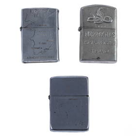
WWII Korea & Vietnam Era Silver Lighters 3pc LOTHill Auction Gallery 4.7(1k)See Sold PriceFeb 28, 2024
Mitchell - Map of the City of Washington (Washington, DC)Trillium Antique Prints & Rare Books4.5(30)See Sold PriceFeb 24, 2024
États du Roi de Maroc… d’Alger, Tunis & Tripoli. North Africa. BONNE 1790 mapJasper524.5(9.8k)See Sold PriceFeb 28, 2024
Royaumes, Etats et Pays de la Haute Guinée. Gulf of Guinea. BONNE 1788 old mapJasper524.5(9.8k)See Sold PriceFeb 28, 2024
AFRICA. Shows Mountains of Kong/the Moon. Caravan routes. RAPKIN/TALLIS 1851 mapJasper524.5(9.8k)See Sold PriceFeb 28, 2024
Partie Occidentale de l’Afrique. West Africa coast Canary islands BONNE 1788 mapJasper524.5(9.8k)See Sold PriceFeb 28, 2024
États du Roi de Maroc… d’Alger, Tunis & Tripoli. North Africa. BONNE 1788 mapJasper524.5(9.8k)See Sold PriceFeb 28, 2024
Two Hand-Colored 19th Century Maps of New Orleans and Louisiana, Larger- H.- 12 1/2 in., W.- 15 1/2Crescent City Auction Gallery4.3(231)See Sold PriceMar 08, 2024