SoldRüdinger (Hg.) Atlas des menschlichen GehöMedizin Rüdinger (Hg.) Atlas des menschlichen Gehörorganes. Mit 5 OPhotographien von Dr. P. Zieger. Silbergelatineabzüge, 20,5 x 15 cm, montiert auf Karton (32 x 24 cm). Lose in HLwd.MaSee Sold Price
Rüdinger (Hg.) Atlas des menschlichen GehöMedizin Rüdinger (Hg.) Atlas des menschlichen Gehörorganes. Mit 5 OPhotographien von Dr. P. Zieger. Silbergelatineabzüge, 20,5 x 15 cm, montiert auf Karton (32 x 24 cm). Lose in HLwd.MaSee Sold Price
Rüdinger, Nikolaus Atlas des peripherischenRüdinger, Nikolaus Atlas des peripherischen Nervensystems des menschlichen Körpers = Atlas du système nerveux périphérique du corps humain / bearb. von Dr. Rüdinger. Mit einem Vorw. von Th. W. LSee Sold Price
Valenciennes, Achille Ichthyologie des Iles Canaries,Valenciennes, Achille Ichthyologie des Iles Canaries, ou histoire naturelle des Poissons. 1 Bd. von 3 in 10 (hg. v. Philip Barker Webb u. Sabin Berthelot) u. Atlas der Reihe "Histoire naturelle des IlSee Sold Price
SoldValenciennes, Achille Ichthyologie des Iles Canaries,IchthyologieValenciennes, AchilleIchthyologie des Iles Canaries, ou histoire naturelle des Poissons. 1 Bd. von 3 (in 10) (hg. v. Philip Barker Webb u. Sabin Berthelot) u. Atlas der Reihe "Histoire natSee Sold Price
Achille Valenciennes Ichthyologie des Iles Canaries ouIchthyologie Achille Valenciennes Ichthyologie des Iles Canaries ou histoire naturelle des Poissons. 1 Bd. von 3 (in 10) (hg. v. Philip Barker Webb u. Sabin Berthelot) u. Atlas der Reihe "Histoire natSee Sold Price
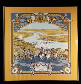
Sold1774 ATLAS Bruyset 23 Color Maps AMERICA Scandinavia1774 ATLAS Bruyset 23 Color Maps AMERICA Scandinavia France Geography RARE ‘Atlas des enfans’ or ‘Children’s Atlas’ is a rare, late 18th-century atlas designed by Jean Marie Bruyset to makeSee Sold Price
Sold1774 ATLAS Bruyset 25 Color Maps AMERICA Scandinavia1774 ATLAS Bruyset 25 Color Maps AMERICA Scandinavia France Geography RARE ‘Atlas des enfans’ or ‘Children’s Atlas’ is a rare, late 18th-century atlas designed by Jean Marie Bruyset to makeSee Sold Price
Sold1774 ATLAS Bruyset 23 Color Maps AMERICA Scandinavia1774 ATLAS Bruyset 23 Color Maps AMERICA Scandinavia France Geography RARE ‘Atlas des enfans’ or ‘Children’s Atlas’ is a rare, late 18th-century atlas designed by Jean Marie Bruyset to makeSee Sold Price
SoldFramed Burgundy Cote De Nuit Vineyards MapFramed ATLAS DES GRANDS VIGNOBLES DE BOURGOGNE ‘Cote de Nuit’ topographic Map. Image includes detailed information about various vineyards along Cote de Nuit in Burgundy France. Map designed by SySee Sold Price
SoldMushrooms, Joseph Roques 1864Print Title: Des Champignons Artist: Joseph Roques Date: 1864 Publisher: N. Remond Imp. Dimensions: 9.25 x 12.5 inches From "Atlas Des Champignons" translated from French is "The Atlas of Mushrooms" NSee Sold Price
SoldFOLIO ATLAS- "DESCRIPTION EXACTE DES ISLES DE L'ARFOLIO ATLAS- "DESCRIPTION EXACTE DES ISLES DE L'ARCHIPEL ET DE QUELQUES AUTRES ADJACENTES...", DAPPER, PUBLISHED BY GEORGE, AMSTERDAM FIRST FRENCH ED., 1703 (LEATHER RE-BIND)See Sold Price
1852 Levasseur Map Atlas of France with America1852 Levasseur Atlas of France with America -- Atlas National Illustre des 86 Departements et des Possessions de la France… V. Levasseur 1852, Paris 21.8 X 14.8 in. This is a seminal large atlas whiSee Sold Price
SoldLobi. Westafrikanische SkulpturenLobi. Westafrikanische Skulpturen Hg. anlässlich der Ausstellung "Die Entdeckung des Individuums" Juli - Oktober 2016 in der Lutherstadt Wittenberg. CHF 50 / 100 EUR 43 / 86See Sold Price
SoldAN ANTIQUE MAP, "Map of Texas," DES MOINES, IOWA, CIRCAAN ANTIQUE MAP, "Map of Texas," DES MOINES, IOWA, CIRCA 1912, color engraving on paper, a fragment from a larger atlas, pages 36-37, published by The Kenyon Company, with view of the "Southern PortionSee Sold Price
SoldV Malte-Brun: Carte des Etats-Unis d'Amerique, 1830Map: Carte des Etats-Unis d'Amerique Maker: V Malte-Brun Date: 1830, Brussels/Bruxelles Description: Impactful map of the US, with part of British Columbia shown as US possession. Texas is part of MexSee Sold Price
SoldBellin: Carte des Isles Bermudes ou de Sommer, 1764Map: Carte des Isles Bermudes ou de Sommer Cartographer: Bellin Place & Date: Paris / 1764 Size: 12 3/4" x 8" The uncommon and beautifully detailed map of Bermuda divided into parishes, from Bellin'sSee Sold Price
SoldCarte du Canal des Isles Philippines, G. Anson 1749Title: Carte du Canal des Isles Philippines Subject: Philippines Maker: George Anson Date: 1749, London Size: 21 x 16.5 inches Chart of the Philippines showing the route of the Spanish treasure ships,See Sold Price
SoldHistoire Generale Des Voiages with Maps, 1759Histoire Generale Des Voiages 1759 with fold-out maps. We ship most items in-house with the exception of furniture, large or heavy artwork, heavier items or extremely fragile items.See Sold Price
SoldAntique Map: Estats de l'Empire du Grand Seigneur desSanson's map of the Ottoman Empire, extending from Italy to the Straits of Hormuz. Minor hand-coloring. 21" wd x 16" ht.See Sold Price
SoldL'Isle Formose et Partie des Costes de la Chine MapBellin's highly detailed folding map of Taiwan (Formosa) and the coast of Fukien province, based on Jesuit sources, from Prevost d'Exiles' influential collection of travel narratives, Histoire GeneralSee Sold Price
SoldAntique Map: Estats De L'Empire Du Grand Seigneur DesHighly detailed chart of the Turkish Empire, and Mediterranean, from Hubert Jaillot. Unframed, Extends from the Arabian Peninsula and the Empire of Persia in the east to Algeria, the Balearic Islands,See Sold Price
Carte des Isles de Maiorque, Minorque et d'YviceMap: Carte des Isles de Maiorque, Minorque et d'Yvice Cartographer: Lotter Place & Date: Augsburg / 1770 Size: 22" x 18 1/4" Condition: old color (cartouche in b&w) overall age toning and some staininSee Sold Price
SoldGroup (4) Antiquarian Books.Group (4) Antiquarian books. Renati Des Cartes Opera Philosophica 1692, Thucydides de Bello Pelopponnesiaco Libri VIII Iidem Latine, ex interpretatione 1588, (2) Volumes, Joh Nep Kriegers Mond-Atlas RSee Sold Price
LARGE EARLY 18TH C. DUTCH CHART OF UPPER NORTH AMERICA, PIERRE MORTIER (1661-1711), FRAMEDThomaston Place Auction Galleries4.4(386)See Sold PriceFeb 24, 2024
Duval - Pair: Map of Georgia & Map of Moscow, RussiaTrillium Antique Prints & Rare Books4.5(30)See Sold PriceFeb 24, 2024
Duval - Pair: Map of India & Map of MaldivesTrillium Antique Prints & Rare Books4.5(30)See Sold PriceFeb 24, 2024
1764 Bellin Chart of Three South Haitian Bays -- Carte des Bayes du Mesle des Flamands et deJasper524.5(9.8k)See Sold PriceFeb 27, 2024
1764 Bellin Map of Port Antonio, Jamaica -- Plan des Havres de Port Antonio et de Saint FrancoisJasper524.5(9.8k)See Sold PriceFeb 27, 2024
Afrique. Pays des Hottentots #50. Namibia South Africa VANDERMAELEN 1827 mapJasper524.5(9.8k)See Sold PriceFeb 28, 2024
Afrique. Pays des Hottentots #51. Botswana South Africa. VANDERMAELEN 1827 mapJasper524.5(9.8k)See Sold PriceFeb 28, 2024
Henri Romagnesi (1912 - 1999) - Set of 8 Mushroom Prints - Rhodophyllus - Entoloma sinuatum -Proverde Auctions4.3(3)See Sold PriceFeb 28, 2024
Henri Romagnesi (1912 - 1999) - Set of 8 Mushroom Prints - Rhodophyllus - Inocybe aeruginascensProverde Auctions4.3(3)See Sold PriceFeb 28, 2024
GAVOY, EMILE. 1836-1896. Atlas d'anatomie topographique du cerveau et des localisations cér...Bonhams4.1(305)See Sold PriceJun 18, 2024