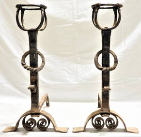
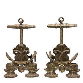
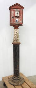
Fine Pair of Nautical Anchor and Dolphin AndironsPremier Auction Galleries4.3(331)See Sold PriceMar 09, 2024
EARLY CAST IRON FIRE BACK DATED 1749 (35" X 28")Carlsen Gallery, Inc.4.6(164)See Sold PriceMar 03, 2024
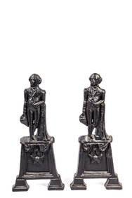
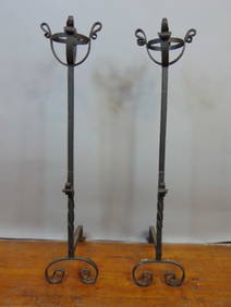
FIGURAL GEORGE WASHINGTON CAST IRON ANDIRONSJohn McInnis Auctioneers,LLC4.5(505)See Sold PriceFeb 25, 2024
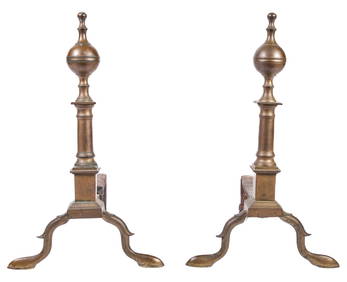
PAIR OF (18th c) STEEPLE TOP BRASS ANDIRONSJohn McInnis Auctioneers,LLC4.5(505)See Sold PriceFeb 25, 2024
Louis XVI Style Architectural Four Panel ScreenAuctions at Showplace4.6(740)See Sold PriceFeb 13, 2025
Large Antique Fireplace Screen Late 19th C.Epic Auctions and Estate Sales4.6(210)See Sold PriceMar 02, 2024
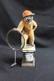
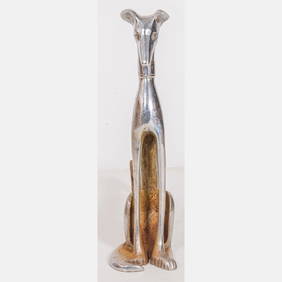
A Pair of Art Deco Chrome-plated Steel Seated Whippet AndironsGray's Auctioneers4.5(187)See Sold PriceMar 06, 2024
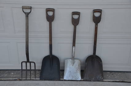
Four Assorted Coal Shovels and Pitchfork-Erie RR/New York Central RRJM Hobby Supply and Railroad Artifact Auctions4.4(127)See Sold PriceFeb 24, 2024
Robert Sayer - A New Map Of The Whole Continent OfRobert Sayer - A New Map Of The Whole Continent Of America (southern Section), 1786 Size: 36 X 16 In. - This Is A Gallery Stretched Giclee Print On Canvas. The Piece Was Printed On High Quality ArtistSee Sold Price
ROBERT SAYER - A NEW MAP OF THE WHOLE CONTINENT ORobert Sayer - A New Map Of The Whole Continent Of America (Southern Section), 1786 - Giclée On Canvas - 44 X 19 5/8 In. A Giclée Print Is The Highest Quality Print Available Today. Because There IsSee Sold Price
ROBERT SAYER - A NEW MAP OF THE WHOLE CONTINENT OFRobert Sayer - A New Map Of The Whole Continent Of America (southern Section), 1786 - 40 X 17 3/4 In. - This Giclée Print Is Gallery Stretched And Ready To Hang Or Lean Against A Wall, Or Display OnSee Sold Price
ROBERT SAYER - A NEW MAP OF THE WHOLE CONTINENT OFRobert Sayer - A New Map Of The Whole Continent Of America (southern Section), 1786 - 40 X 17 3/4 In. - This Giclée Print Is Gallery Stretched And Ready To Hang Or Lean Against A Wall, Or Display OnSee Sold Price
ROBERT SAYER -A NEW MAP OF THE WHOLE CONTINENT OFRobert Sayer -a New Map Of The Whole Continent Of America (southern Section), 1786 - Giclée On Canvas -40 X 17 3/4 In. - A Giclée Print Is The Highest Quality Print Available Today. Because There IsSee Sold Price
ROBERT SAYER - A NEW MAP OF THE WHOLE CONTINENT OFRobert Sayer - A New Map Of The Whole Continent Of America (southern Section), 1786 - 36 X 16 In. - Giclée Print - Gallery Stretched - Ready to hang.See Sold Price
ROBERT SAYER - A NEW MAP OF THE WHOLE CONTINENT OFRobert Sayer - A New Map Of The Whole Continent Of America (southern Section), 1786 - 36 X 16 In. - This Giclée Print Is Gallery Stretched And Ready To Hang Or Lean Against A Wall, Or Display On An ESee Sold Price
ROBERT SAYER - A NEW MAP OF THE WHOLE CONTINENT OFRobert Sayer - A New Map Of The Whole Continent Of America (southern Section), 1786 - 40 X 17 3/4 In. - This Giclée Print Is Gallery Stretched And Ready To Hang Or Lean Against A Wall, Or Display OnSee Sold Price
Robert Sayer - A New Map Of The Whole Continent OfRobert Sayer - A New Map Of The Whole Continent Of America (southern Section), 1786 Size: 40 X 17 3/4 In. - This Is A Gallery Stretched Giclee Print On Canvas. The Piece Was Printed On High Quality ArSee Sold Price
ROBERT SAYER - A NEW MAP OF THE WHOLE CONTINENT OFRobert Sayer - A New Map Of The Whole Continent Of America (southern Section), 1786 - 44 X 19 5/8 In. - This Giclée Print Is Gallery Stretched And Ready To Hang Or Lean Against A Wall, Or Display OnSee Sold Price
ROBERT SAYER - A NEW MAP OF THE WHOLE CONTINENT OFRobert Sayer - A New Map Of The Whole Continent Of America (southern Section), 1786 - 40 X 17 3/4 In. - This Giclée Print Is Gallery Stretched And Ready To Hang Or Lean Against A Wall, Or Display OnSee Sold Price
SoldA NEW MAP OF THE WHOLE CONTINENT OF AMERICA (SOUTHERNRobert Sayer - A New Map Of The Whole Continent Of America (southern Section), 1786 - 40 X 17 3/4 In. - This Giclée Print Is Gallery Stretched And Ready To HangSee Sold Price
SoldSayer (Robert) - A New Map of the Whole Continent ofNorth and South America, with inset map of the Baffin and Hudson Bays, large decorative title cartouche, engraved map with original outline hand-colouring, cartouche uncoloured, 1040 x 1180mm., verticSee Sold Price
Sayer (Robert) - A New Map of the Whole Continent ofNorth and South America, with inset map of the Baffin and Hudson Bays, large decorative title cartouche, engraved map with original outline hand-colouring, cartouche uncoloured, 1040 x 1180mm., verticSee Sold Price
Americas.- Sayer (Robert) and John Bennett. A New MapAmericas.- Sayer (Robert) and John Bennett. A New Map of the Whole Continent of America, Divided into North and South and West Indies, large-scale 4 sheet map, with extensive details and rococo-styleSee Sold Price
Sayer Set of 4 Wall Maps of ContinentsSAYER, Robert & KITCHEN, Thomas, after D'ANVILLE, Jean-Baptiste Bourguignon (1697-1782). [Continents, Set of 4] 1. A New map of the whole continent of America, divided into North and South. 2. AfricaSee Sold Price
SoldLarge map of Americas 1786Heading: (Americas) Author: Sayer, Robert Title: A New Map of the Whole Continent of America. Divided into North and South and West Indies, wherein are exactly described the United States of North AmeSee Sold Price
SoldAmericas.- Sayer (Robert) A Map of the Whole ContinentAmericas.- Sayer (Robert) A Map of the Whole Continent of America divided into North and South and West Indies with a copious table, large wall map with impressive detail, based on the cartography ofSee Sold Price
Sold1 piece. Hand-Colored Engraved Map. Laurie, Rober1 piece. Hand-Colored Engraved Map. Laurie, Robert; Whittle, James. A New Map of The Whole Continent of America; Divided into North and South and West Indies, wherein are exactly The United States ofSee Sold Price
SoldLAURIE, ROBERT; and WHITTLE, JAMES. A New Map of theLAURIE, ROBERT; and WHITTLE, JAMES. A New Map of the Whole Continent of America, divided into North and South and West Indies, wherein are exactly described the United States of North America. Large eSee Sold Price
Gibson / Sayer: Antique Map of Western Hemisphere, 1786Map: A New Map of the Whole Continent of America Divided into North and South and West Indies wherein are exactly Described the United States of North America Cartographer: J. Gibson / R. Sayer PlaceSee Sold Price
SoldSAMUEL DUNN HAND COLORED PRINTED MAPSAMUEL DUNN, HAND COLORED PRINTED MAP, IMAGE: H 19", W 12 1/2", "A NEW MAP OF THE UNITED STATES OF NORTH AMERICA":"--- with the British Dominions on the continent"; printed for Robert Sayer; framed.See Sold Price
SoldGibson Laurie Whittle NEW MAP OF THE WHOLE CONTINENT OFDetails: [GIBSON, John] - LAURIE & WHITTLE, publishers. A New Map of the Whole Continent of America, divided into North and South America and West Indies, wherein are described the United States of NSee Sold Price
SoldA NEW MAP OF THE WHOLE CONTINENT OF AMERICA. EngravedA NEW MAP OF THE WHOLE CONTINENT OF AMERICA. Engraved and colored map. London, by Laurie & Whittle, May 1794. 101 x 118 cmSee Sold Price
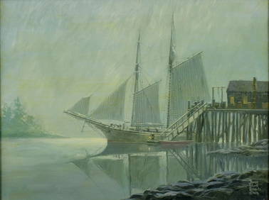
Bruce Elliot Roberts (NY,FL,1917-1993) oil paintingBroward Auction Gallery4.7(292)See Sold PriceMar 10, 2024
Bruce Elliot Roberts (NY,FL,1917-1993) oil paintingBroward Auction Gallery4.7(292)See Sold PriceMar 17, 2024
Portfolio of 15 County Maps by Robert Morden (English 1650-1703)Nadeau's Auction Gallery4.7(409)See Sold PriceFeb 24, 2024
1872 Holy BIBLE & Hitchcock Analysis Gruden Concordance Theology MAPS Holy LandSchilb Antiquarian Rare Books4.8(428)See Sold PriceMar 31, 2024
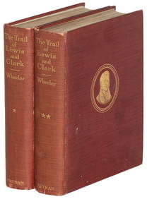
Pair of The Gateway to a Continent Books - Grand Central Zone and 1939 World's FairRail & Road Auctions4.6(165)See Sold PriceMar 07, 2024
Keith Haring - Ink on New York Map, Best Buddies, Inscribed, Signed, and DatedSapphire Auction Gallery4.1(67)See Sold PriceMar 02, 2024
New and Correct Map of North America With the West India Islands,Jasper524.5(9.9k)See Sold PriceFeb 27, 2024
Buffon, Vaugody & Bell 1785 America - Map of the New ContinentAlbion Auctions4.7(341)See Sold PriceMar 01, 2024
Robert Benard (1734 - 1777) - Set of 9 Copperplate Engravings - Greek and Roman architecture - ViewProverde Auctions4.3(3)See Sold PriceFeb 28, 2024
Robert Benard (1734 - 1777) - Set of 9 Copperplate Engravings - Architecture, Masonry, Quarry withProverde Auctions4.3(3)See Sold PriceFeb 28, 2024
Robert Benard (1734 - 1777) - Set of 9 Chemical Engravings - Alchemical symbols - Utensils forProverde Auctions4.3(3)See Sold PriceFeb 28, 2024
Robert de Vaugondy - Map of Canada - Mer de l' Ouest or Sea of the West and a Northwest PassageProverde Auctions4.3(3)See Sold PriceFeb 28, 2024
Robert H Labberton - Map of The Territory of the Present United States - The territory of theProverde Auctions4.3(3)See Sold PriceFeb 28, 2024