SoldReport on Alaska with map of Stickeen River 1868Heading: (Alaska) Author: Title: Russian America: Message from the President of The United States, in answer to a resolution of the House of 19th of December last, transmitting correspondence in relaSee Sold Price
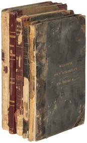
Sold[Americana - Alaska] Group of 4 Alaska Reports - Copper[Americana - Alaska] Group of 4 Alaska Reports - Copper River, Reindeer, Etc. -- Maps and Illustrations Allen, Lieut. Henry Tureman. REPORT OF AN EXPEDITION TO THE COPPER, TANANA AND KOYUKUK RIVERS ISee Sold Price
Bache Map of Potomac River, 1868Bache, Alexander D. (1806-1867). Potomac River (in Four Sheets). Lithographed Maps. U. S. Coast Survey, 1868. 23" x 29 ½" each. Details soundings, points, buoys, etc. Also Washington, D.C., GeorgetSee Sold Price
SoldMoran, Thomas, 1837-1926Moran, Thomas, 1837-1926, Baby Glacier 5 Miles Below 'Big Canyon,' Stickeen River, Alaska, June 17, ca. 1895, lithographic pencil and ink on coquille-surfaced paper, 6 5/8 x 4 1/2 inches (sight), initSee Sold Price
SoldReport on Union Pacific R.R. with map 1868Heading: (Union Pacific Railroad) Author: Dodge, G[renville] M. Title: Report of G.M. Dodge, chief engineer, to the Board of Directors on a branch railroad line from the Union Pacific Railroad to IdahSee Sold Price
SoldReport on Union Pacific R.R. with map 1868Title: Report of G.M. Dodge, chief engineer, to the Board of Directors on a branch railroad line from the Union Pacific Railroad to Idaho, Montana, Oregon, and Puget's Sound. Author: Dodge, G[renvilleSee Sold Price
Report on Alaska, Washington DC GPO, 1884 With mapsPetroff (Special Census Agent) Ivan. Report on the population, industry and resources of Alaska. Washington, DC: GPO, 1884. 4to, pb, 86 pages. With maps. Note: 46th Congress, 3rd Session, House ExecutSee Sold Price
SoldALASKAN REPORT MG Clements McMullen, Dec 1943ALASKAN REPORT MG Clements McMullen, Dec 1943: MG McMullen's 1943 Report on the Airforce Bases in Alaska , Includes Maps, Descriptions, Pictures, Condition of the Bases, Problems, and Recommendations.See Sold Price
SoldExploration of the Yellowstone River 1868Heading: Author: Raynolds, William F. Title: Report on the Exploration of the Yellowstone River... Communicated by the Secretary of War, in Compliance with a Resolution of Senate, February 13, 1866 PSee Sold Price
SoldExploration of the Yellowstone River 1868Heading: Author: Raynolds, Bvt. Brig. Gen. W[illiam] F. Title: Report on the Exploration of the Yellowstone River...Communicated by the Secretary of War, in Compliance with a Resolution of Senate, FeSee Sold Price
SoldUnion Pacific with large map 1868Heading: (Union Pacific Railroad) Author: Dodge, G[renville] M. Title: Report of G.M. Dodge, chief engineer, to the Board of Directors on a branch railroad line from the Union Pacific Railroad to IdahSee Sold Price
SoldCoast Survey maps, 1868 and 1851[U.S. Coast Survey]. 2 Titles. Wash: GPO. 4to. ++ Report Of The Superintendent Of The United States Coast Survey Showing the Progress of the Survey during the Year 1868. House issue. 1871. xiii,277pp.See Sold Price
SoldConstruction of Union Pacific with map 1868Heading: Author: Perry, John D., et al. Title: Letter of John D. Perry, President of the Union Pacific Railway (Eastern Division) together with the reports of the engineer and the geologist of the roSee Sold Price
SoldCoast Survey with Alaska maps 1869Heading: Author: U.S. Coast Survey Title: Report of the Superintendent of the United States Coast Survey, Showing the Progress of the Survey During the Year 1867 Place Published: Washington PublisherSee Sold Price
SoldConstruction of Union Pacific with map 1868Heading: (Union Pacific Railway) Author: Perry, John D., et al. Title: Letter of John D. Perry, President of the Union Pacific Railway (Eastern Division) together with the reports of the engineer andSee Sold Price
1899 Cram Map of Alaska [verso] Comparison of RiversTitle: 1899 Cram Map of Alaska [verso] Comparison of Rivers and Mountains in W Hemisphere -- Alaska [verso] Western Hemisphere Date: 1899, Chicago, New York Cartographer: G Cram Size: 12.8 x 19.9 in.See Sold Price
1899 Cram Map of Alaska [verso] Comparison of RiversTitle/Content of Map: 1899 Cram Map of Alaska [verso] Comparison of Rivers and Mountains in W Hemisphere -- Alaska [verso] Western Hemisphere Date Printed: 1899, Chicago, New York Cartographer: G CramSee Sold Price
1899 Cram Map of Alaska [verso] Comparison of RiversTitle/Content of Map: 1899 Cram Map of Alaska [verso] Comparison of Rivers and Mountains in W Hemisphere -- Alaska [verso] Western Hemisphere Date Printed: 1899, Chicago, New York Cartographer: G CramSee Sold Price
1899 Cram Map of Alaska [verso] Comparison of RiversTitle/Content of Map: 1899 Cram Map of Alaska [verso] Comparison of Rivers and Mountains in W Hemisphere -- Alaska [verso] Western Hemisphere Cartographer: G Cram Size: 12.8 x 19.9 in. A very nice mapSee Sold Price
1899 Cram Map of Alaska [verso] Comparison of RiversTitle/Content of Map: 1899 Cram Map of Alaska [verso] Comparison of Rivers and Mountains in W Hemisphere -- Alaska [verso] Western Hemisphere Date: 1899, Chicago, New York Cartographer: G Cram Size: 1See Sold Price
SoldCram: Map of Alaska verso W Hemisphere, 1901Map: 1901 Cram Map of Alaska [verso] Comparison of Rivers and Mountains in Western Hemisphere Maker: G Cram Published: 1901, Chicago, New York Size: 12.8 x 19.9 in A very nice map of Alaska with greatSee Sold Price
Cram: Antique Map of Alaska, 1899Title/Content of Map: 1899 Cram Map of Alaska [verso] Comparison of Rivers and Mountains in W Hemisphere -- Alaska [verso] Western Hemisphere Date Printed: 1899, Chicago, New York Cartographer: G CramSee Sold Price
Cram: Antique Map of Alaska verso West Hemisphere, 1899Title/Content of Map: 1899 Cram Map of Alaska [verso] Comparison of Rivers and Mountains in W Hemisphere -- Alaska [verso] Western Hemisphere Date Printed: 1899, Chicago, New York Cartographer: G CramSee Sold Price
Sold(ALASKA.) Ray, Patrick Henry. Report of the In(ALASKA.) Ray, Patrick Henry. Report of the International Polar Expedition to Point Barrow Alaska. Folding map, numerous plates, including 10 photogravures by F. Gutekunst. 4to, publisher's cloth, somSee Sold Price
Atlantic and Pacific RY Annual Report-April 30, 1868JM Hobby Supply and Railroad Artifact Auctions4.4(127)See Sold PriceFeb 24, 2024
Chicago and Eastern Illinois RR Annual Reports-1878 to 1887JM Hobby Supply and Railroad Artifact Auctions4.4(127)See Sold PriceFeb 24, 2024
Lake Superior and Mississippi River RR 1869 Seven Percent Bonds Book/Report-1869JM Hobby Supply and Railroad Artifact Auctions4.4(127)See Sold PriceFeb 24, 2024
Rand McNally Railroad Map of Washington-1906JM Hobby Supply and Railroad Artifact Auctions4.4(127)See Sold PriceFeb 24, 2024
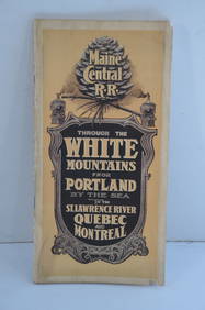
Maine Central RR Through the White Mtns-Portland to the St Lawrence River Book-1901JM Hobby Supply and Railroad Artifact Auctions4.4(127)See Sold PriceFeb 24, 2024
Union Pacific RR Across The Continent West From Omaha, NE Book-April 2, 1868JM Hobby Supply and Railroad Artifact Auctions4.4(127)See Sold PriceFeb 24, 2024
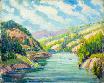
Alma H Borgfeldt (AK,1881-1969) oil paintingBroward Auction Gallery4.7(292)See Sold PriceMar 17, 2024
EDWARD SHERRIFF CURTIS (Washington/California, 1868-1952), "Flathead Camp on the Jocko River",Eldred's4.7(419)See Sold PriceFeb 28, 2024
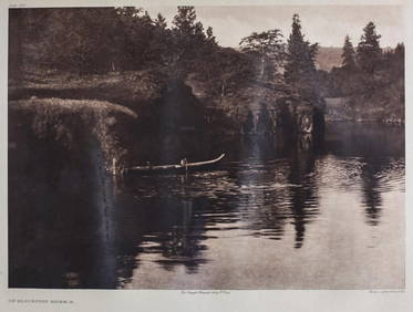
Edward S Curtis American 1868-1952 Photogravure Klickitat River PhotographGlobal Auctions Company4.3(36)See Sold PriceMar 03, 2024
Signed Yvonne Jacquette Screenprint, 'Fog River IV,' 1 of 2PUBLIC SALE4.7(226)See Sold PriceMar 02, 2024
Signed Yvonne Jacquette Screenprint, 'Fog River IV,' 2 of 2PUBLIC SALE4.7(226)See Sold PriceMar 02, 2024
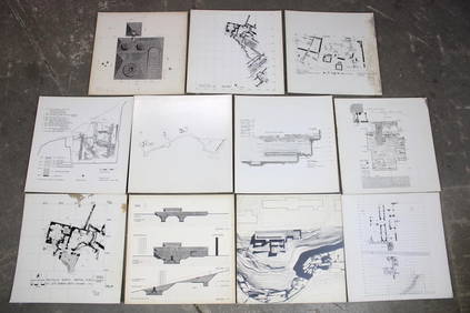
Set of 11 Mid Century Modern Architectural Plans & Site Map RenderingsPUBLIC SALE4.7(226)See Sold PriceMar 02, 2024
John Senex Map of Louisiana & Mississippi RiverWillow Auction House4.5(289)See Sold PriceMar 14, 2024
Hudson River Map & North American Postcards, 45Auctions at Showplace4.6(740)See Sold PriceFeb 13, 2025


![[Americana - Alaska] Group of 4 Alaska Reports - Copper (1 of 10)](https://p1.liveauctioneers.com/46/113409/58240907_1_x.jpg?height=282&quality=70&version=1512492316)


![1899 Cram Map of Alaska [verso] Comparison of Rivers (1 of 2)](https://p1.liveauctioneers.com/5584/159675/80583698_1_x.jpg?height=282&quality=70&version=1579644740)
![1899 Cram Map of Alaska [verso] Comparison of Rivers (1 of 2)](https://p1.liveauctioneers.com/5584/120548/61369190_1_x.jpg?height=282&quality=70&version=1524013707)
![1899 Cram Map of Alaska [verso] Comparison of Rivers (1 of 2)](https://p1.liveauctioneers.com/5584/117686/60488575_1_x.jpg?height=282&quality=70&version=1520991879)
![1899 Cram Map of Alaska [verso] Comparison of Rivers (1 of 2)](https://p1.liveauctioneers.com/5584/141761/71765296_1_x.jpg?height=282&quality=70&version=1557879901)
![1899 Cram Map of Alaska [verso] Comparison of Rivers (1 of 2)](https://p1.liveauctioneers.com/5584/123035/62600068_1_x.jpg?height=282&quality=70&version=1528244596)