Rendsburgum Map, J. Mejer C. 1660Rendsburgum, Chilonium et Bordesholma. Colored copper engraving. C. 1660, Amsterdam.See Sold Price
Sold(European Regional, Germany), Three maps: Mejer, J(European Regional, Germany), Three maps: Mejer, Johannes, Comitatus Pinnenberg, [Amsterdam], c. 1650, originally published in Danckwerth?s atlas and the in Blaeu's Atlas Minor, double-page with laterSee Sold Price
1660 Jansson Map of the Arabian Peninsula and Red SeaTitle/Content of Map: 1660 Jansson Map of the Arabian Peninsula and Red Sea -- Arabiae Felicis, Petrae ae et Desertae Nova et Accurata Delineatio Date: 1660 c., Amsterdam Cartographer: J Jansson Size:See Sold Price
1660 Jansson Map of the Arabian Peninsula and Red SeaTitle/Content of Map: 1660 Jansson Map of the Arabian Peninsula and Red Sea -- Arabiae Felicis, Petrae ae et Desertae Nova et Accurata Delineatio Date: 1660 c., Amsterdam Cartographer: J Jansson Size:See Sold Price
1660 Jansson Map of the Arabian Peninsula and Red SeaTitle/Content of Map: 1660 Jansson Map of the Arabian Peninsula and Red Sea -- Arabiae Felicis, Petrae ae et Desertae Nova et Accurata Delineatio Date: 1660 c., Amsterdam Cartographer: J Jansson Size:See Sold Price
1660 Jansson Map of the Arabian Peninsula and Red SeaTitle/Content of Map: 1660 Jansson Map of the Arabian Peninsula and Red Sea -- Arabiae Felicis, Petrae ae et Desertae Nova et Accurata Delineatio Date: 1660 c., Amsterdam Cartographer: J Jansson Size:See Sold Price
Sold1660 Jansson Map of the Arabian Peninsula and Red SeaTitle: 1660 Jansson Map of the Arabian Peninsula and Red Sea -- Arabiae Felicis, Petrae ae et Desertae Nova et Accurata Delineatio Cartographer: J Jansson Year / Place: 1660 c., Amsterdam Map DimensioSee Sold Price
1660 Jansson Map of the Arabian Peninsula and Red SeaTitle/Content of Map: 1660 Jansson Map of the Arabian Peninsula and Red Sea -- Arabiae Felicis, Petrae ae et Desertae Nova et Accurata Delineatio Cartographer: J Jansson Year/Place: 1660 c., AmsterdamSee Sold Price
1660 Jansson Map of the Arabian Peninsula and Red SeaTitle/Content of Map: 1660 Jansson Map of the Arabian Peninsula and Red Sea -- Arabiae Felicis, Petrae ae et Desertae Nova et Accurata Delineatio Cartographer: J Jansson Year/Place: 1660 c., AmsterdamSee Sold Price
1660 Jansson Map of the Arabian Peninsula and Red SeaTitle/Content of Map: 1660 Jansson Map of the Arabian Peninsula and Red Sea -- Arabiae Felicis, Petrae ae et Desertae Nova et Accurata Delineatio Cartographer: J Jansson Year/Place: 1660 c., AmsterdamSee Sold Price
1660 Jansson Map of the Arabian Peninsula and Red SeaTitle: 1660 Jansson Map of the Arabian Peninsula and Red Sea -- Arabiae Felicis, Petrae ae et Desertae Nova et Accurata Delineatio Date: 1660 c., Amsterdam Cartographer: J Jansson Size: 17.3 X 20.2 inSee Sold Price
1660 Jansson Map of the Arabian Peninsula and Red SeaTitle: 1660 Jansson Map of the Arabian Peninsula and Red Sea -- Arabiae Felicis, Petrae ae et Desertae Nova et Accurata Delineatio Cartographer: J Jansson Year/Place: 1660 c., Amsterdam Map DimensionsSee Sold Price
SoldTwo engraved and hand-colored maps of Egypt1) J. Blaeu, "Nova Aegypti Tabula," circa 1670, 17 1/4 X 20 1/2 in., p.m.; 2) Pierre Du Val, "Aegyptus Antiqua Divisa in Nomos," (Amsterdam: c.1660), 15 1/4 X 20 1/2 in., p.m.; Property from the HansSee Sold Price
1660 Speed Map of Hertfordshire, UKTitle: 1660 c. Speed Map of Hertfordshire, UK - Hartford Shire Described the Sittuations of Hartford, and the Most Ancient Towne S Albons with such Memorable Actions as have Happened Cartographer: J.See Sold Price
Speed Map of Hertfordshire, UK, 1660Map: 1660 c. Speed Map of Hertfordshire, UK - Hartford Shire Described the Sittuations of Hartford, and the Most Ancient Towne S Albons with such Memorable Actions as have Happened Cartographer: J. SpSee Sold Price
Speed: Map of Hertfordshire, UK, 1660Map: 1660 c. Speed Map of Hertfordshire, UK - Hartford Shire Described the Sittuations of Hartford, and the Most Ancient Towne S Albons with such Memorable Actions as have Happened Cartographer: J. SpSee Sold Price
Speed: Antique Map of Hertfordshire, UK, 1660Map: 1660 c. Speed Map of Hertfordshire, UK - Hartford Shire Described the Situations of Hartford, and the Most Ancient Towne S Albons with such Memorable Actions as have Happened Cartographer: J. SpeSee Sold Price
SoldANTIQUE FLORIDA MAP, J & C Walker, 20 x 16 inches,ANTIQUE FLORIDA MAP, J & C Walker, 20 x 16 inches, overall framed size 22 x 18 inchesSee Sold Price
Sold(2) early maps, J Covens & C Mortier, Amsterdam, c(2) early maps, J Covens & C Mortier, Amsterdam, c 1730, Carte de la Prevoste et Vicomte de Paris, a map of Paris and surrounds, image 20" x 24 3/4", generally even color throughout, some coloring, anSee Sold Price
SoldGeological map.- Walker (J. & C.) A Geological Map ofGeological map.- Walker (John & Charles, publishers) A Geological Map of England and Wales, First edition, second state, 'showing also the Inland Navigation by means of Rivers & Canals, with their EleSee Sold Price
SoldSaudi Arabia.- Murray (John) Map of the Northern PartSaudi Arabia.- Murray (John) Map of the Northern Part of Arabia Shewing the Routes of Mr. G.A. Wallin, engraved map by J. & C. Walker, with hand-colouring, 217 x 250 mm. (8 1/2 x 9 7/8 in), central veSee Sold Price
SoldCellarius, Celestial EngravingCoelistelli christiani misphae reiumerius, Pl. 22. Andreas Cellarius (1596-1665). from Harmonia Macrocosmica. Hand-colored Engraving. Amsterdam: J. Janssonius, c. 1660. 20 x 23 inches sheet, 32 x 35 iSee Sold Price
SoldJansson, Nova Belgica et Anglia Nova c.1636[United States: East Coast]. Johannes Jansson. Nova Belgica Et Anglia Nova. Double-page engraved map. c.1635 - 1660. 15 3/8 x 19 7/8 inches. Hand-colored outline, coloring to cartouche and scale.See Sold Price
SoldIndia.- Allen & Co. (William H.) Map of the WesternIndia.- Allen & Co. (William H.) Map of the Western Provinces of Hindoostan, The Punjab, Rajpootana, Sinde, Kabool &c., large and impressive folding map by J. & C. Walker, including parts of AfghanistSee Sold Price
HONEST JOHN OLIVER by James Morton 1st Edition Inscribed by Author ScarceLuis Porretta Fine Arts4.3(10)See Sold PriceMar 02, 2024
Numismatic Books - Whelan - The Numismatic Atlas of the Roman EmpireTimeLine Auctions Ltd.4.6(183)See Sold PriceMar 09, 2024
1675 ELZEVIER JULIUS CAESAR antique ILLUSTRATED w/ MAPS ROMAN HISTORYJasper524.5(9.9k)See Sold PriceFeb 27, 2024
Railways & Transport.- [Prospectus] The Dorking, Brighton, and Arundel Atmospheric Railway, byForum Auctions4.3(53)See Sold PriceFeb 29, 2024
Tour of the Dutch East Indies, with exceptional platesPBA Galleries4.7(385)See Sold PriceMar 07, 2024
THE WHOLE CHRONICLE OF POLYBIUS ANCIENT IN ENGLISH, 1756NY Elizabeth 4.2(86)See Sold PriceMar 03, 2024
1675: ANTIQUE ILLUSTRATED JULIUS CAESAR MAPS OF ROMAN HISTORYNY Elizabeth 4.2(86)See Sold PriceMar 03, 2024
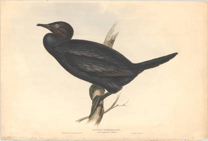
Carl J. Sundevall (1801 - 1875) Set of 4 Bird Prints - Dove - Woodpecker - DuckProverde Auctions4.3(3)See Sold PriceFeb 28, 2024
TWO ANTIQUE JEWISH NATIONAL FUND CHARITY BOXES. The first one made in Berlin c. 1920J. Greenstein & Co., Inc.4.2(55)See Sold PriceApr 16, 2024


![Railways & Transport.- [Prospectus] The Dorking, Brighton, and Arundel Atmospheric Railway, by (1 of 1)](https://p1.liveauctioneers.com/5458/319736/171654703_1_x.jpg?height=282&quality=70&version=1708010439)