SoldRare Map "Johnson's North and South Carolina"Rare uncolored c. 1866 map by Johnson and Ward; fine details showing major roads and railroads; three inserts include map of Charleston Harbor, vignettes of Table Mountain, Chimney Rocks and French BrSee Sold Price
Soldc. 1866 "Johnson's North and South Carolina" MapRare uncolored c. 1866 map by Johnson and Ward; fine details showing major roads and railroads; three inset views include "Plan of Charleston Vicinity & Harbor", "Table Mountain", and "Chimney Rocks aSee Sold Price
SoldMap, Johnson's North & South Carolina,Johnson and Ward, hand colored inset views of "Chimney Rocks and French Broad River", "Table Mountain", and "Plan of Charleston, Vicinity and Harbor", 1860-1870, 17-3/8 x 24 in. (sight); professionallSee Sold Price
SoldMap, Johnson's North and South CarolinaMap, Johnson's North and South CarolinaNew York: Johnson & Ward, n.d.), 1860s, steel engraving with color, inset vignettes of "Chimney Rocks and French Broad River" plus "Table Mountain"; presented inSee Sold Price
SoldMap, "Johnson's North and South Carolina,"Map, "Johnson's North and South Carolina," (New York: Johnson & Ward, ca. 1860s), hand colored steel engraving from folio, fine details showing major roads and railroads, three insets include map of CSee Sold Price
SoldMap, Johnson's North and South Carolinathird quarter 19th century, insets of Charleston, French Broad River, and Table Mountain (Table Rock, NC). Presented behind mat in dark wooden frame. 25.75 x 32 in. Additional high-resolution photosSee Sold Price
SoldRare & Early Map of North & South Carolinaby Henry Mouzon, published by Sawyer and Bennett, London, 1775. giving exceptional detail of key locations in both North & South Carolina. upper sheet: H21 1/2" W54 3/4" lower sheet: H21 1/4" W52 1/4"See Sold Price
SoldMAP: 1865 Johnsons North and South CarolinaMaps“Johnson’s North Carolina and South Carolina” of 1865 1865 “Johnson’s North Carolina and South Carolina,” published by Johnson and Ward, New York, Choice ExtremSee Sold Price
SoldReconstruction Era Map, Johnson's North Carolina andReconstruction Era Map, Johnson's North Carolina and South Carolina(New York: Alvin J. Johnson & Co., 1865), steel engraving with subtle color to counties; inset map of Charleston harbor; presented unSee Sold Price
SoldAntique Map of North and South CarolinaAntique map- Johnson's North Carolina and South Carolina, double page map with hand color, pictorial vignettes, decorative border, image 23 x 16.5, framedSee Sold Price
SoldJohnson: Map of North & South Carolina, 1864Map: 1864 Johnson Map of North and South Carolina Maker: Johnson and Ward Published: 1864, New York Size: 17.3 X 23.8 in. Excellent and highly detailed map of the Carolinas, showing the counties colorSee Sold Price
SoldRare 1967 Mouzon Map of North & South Carolinavery limited production by Louis and Clark Explorer Maps LLC in Kitty Hawk, and Charlotte, North Carolina. reproduction gives excellent detail and very well resembles the original map. marked "L&C" atSee Sold Price
SoldJohnson: Map of North & South Carolina, 1863Johnson’s North and South Carolina, Johnson & Ward, 1863. 17 x 24 inches. A beautiful example of A. J. Johnson's 1863 map of North Carolina and South Carolina. Offers a fascinating snapshot of theseSee Sold Price
Sold1865 A.J. Johnson Map of North & South Carolina,handcolored, image area approx. 17" x 23".See Sold Price
SoldAntique Johnson's Map of North & South Carolina.Antique Johnson's Map of North & South Carolina. An engraved, hand-colored map of North and South Carolina, printed by Johnson and Ward. Most likely the 1866 edition, based on the vignettes, the smallSee Sold Price
Johnson: Map of North & South Carolina, 1864Map: 1864 Johnson Map of North and South Carolina -- Johnson's North and South Carolina Cartographer: Johnson & Ward Year / Place: 1864, New York Map Dimensions: 17.3 x 24 in. An excellent, large mapSee Sold Price
Sold1864 Johnson Map of North and South Carolina --Title/Content of Map: 1864 Johnson Map of North and South Carolina -- Johnson's North and South Carolina Date: 1864, New York Cartographer: Johnson & WardSize: 17.3 x 24 in. An excellent, large, doublSee Sold Price
Sold1862 Johnson Map of North and South Carolina --Title/Content of Map: 1862 Johnson Map of North and South Carolina -- Johnson's North and South Carolina Date: 1864, New York Cartographer: Johnson & Browning Size: 17.3 x 24 in. This is an excellent,See Sold Price
Sold1864 Johnson Map of North and South Carolina --Title/Content of Map: 1864 Johnson Map of North and South Carolina -- Johnson's North and South Carolina Date Printed: 1864, New York Cartographer: Johnson & Ward Size: 17.3 x 24 in. An excellent, larSee Sold Price
Sold1864 Johnson Map of North and South Carolina --Title/Content of Map: 1864 Johnson Map of North and South Carolina -- Johnson's North and South Carolina Date Printed: 1864, New York Cartographer: Johnson & Ward Size: 17.3 x 24 in. An excellent, larSee Sold Price
Sold1865 JOHNSON'S NORTH & SOUTH CAROLINA MAP1865 JOHNSON'S NORTH & SOUTH CAROLINA MAP: Hand colored map, published 1865 by A. J. Johnson, New York. Insets of Table Mountain, Chimney Rocks & French Broad River, and Charleston Harbor. Sight sizeSee Sold Price
1865 Johnson Map of North and South Carolina --Title: 1865 Johnson Map of North and South Carolina -- Johnson's North and South Carolina Cartographer: Johnson & Ward Year / Place: 1865, New York Map Dimension (in.): 17.3 x 24 in. An excellent, larSee Sold Price
1867 Johnson Map of North and South Carolina --Title/Content of Map: 1867 Johnson Map of North and South Carolina -- Johnson's North and South Carolina Cartographer: A Johnson Year/Place: 1867, New York Size: 17.3 x 24 in. This is an excellent, laSee Sold Price
1862 Johnson Map of North and South Carolina --Title/Content of Map: 1862 Johnson Map of North and South Carolina -- Johnson's North and South Carolina Date: 1864, New York Cartographer: Johnson & Browning Size: 17.3 x 24 in. This is an excellent,See Sold Price
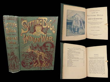
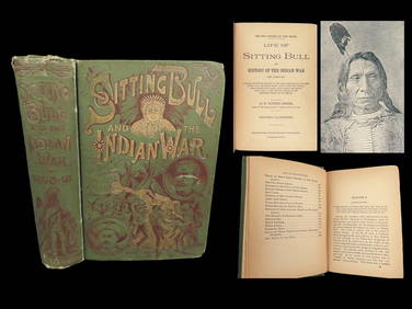
1891 Sitting Bull 1st ed Life Native American Sioux Indians DAKOTA Ghost DanceSchilb Antiquarian Rare Books4.8(421)See Sold PriceMar 10, 2024
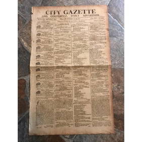
RARE 200 yr old Newspaper, City Gazette, Charleston SCConnoisseur Auctions4(333)See Sold PriceMar 02, 2024
Portfolio of 15 County Maps by Robert Morden (English 1650-1703)Nadeau's Auction Gallery4.7(401)See Sold PriceFeb 24, 2024
1865 Confederate 1st/1st Rebel Prisons TORTURE Andersonville CIVIL WAR Union POWSchilb Antiquarian Rare Books4.8(421)See Sold PriceMar 31, 2024
1891 DAKOTA Indians 1st ed Life Sitting Bull Native American Sioux Ghost DanceSchilb Antiquarian Rare Books4.8(421)See Sold PriceMar 31, 2024
[ENSLAVEMENT & ABOLITION]. Letter from a southern slave trader describing the transportation ofFreeman's | Hindman4.4(1.6k)See Sold PriceFeb 27, 2024
Carey, pub. 1796 - Map of The State of South CarolinaTrillium Antique Prints & Rare Books4.5(30)See Sold PriceFeb 24, 2024
Carey, pub. 1796 - Map of the Tennassee State formerly part of North Carolina (Tennessee)Trillium Antique Prints & Rare Books4.5(30)See Sold PriceFeb 24, 2024
Map: An 18thC engraved and hand coloured map of North America and South America, titled DeClaydon Auctioneers Ltd4.3(125)See Sold PriceFeb 26, 2024
1822 MAP of NORTH & SOUTH AMERICA GEOGRAPHICAL STATISTICAL HISTORICAL antiqueJasper524.5(9.8k)See Sold PriceFeb 27, 2024
Blackie (Pub) 1882 Pair of Folio Maps. Italy - North & SouthAlbion Auctions4.6(336)See Sold PriceMar 01, 2024
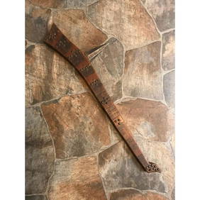
Rare 19thc Native American Indian Gunstock War ClubConnoisseur Auctions4(333)See Sold PriceMar 16, 2024
1850s-61 $5 Bank of the State of South Carolina Obsolete Note PMG Choice Fine 15BK Auctions4.7(1.4k)See Sold PriceFeb 25, 2024
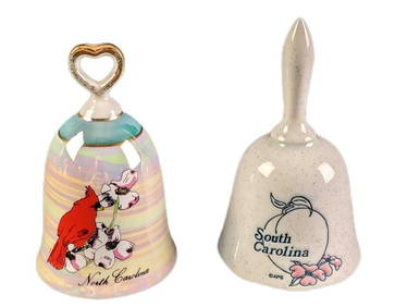
Vintage North And South Carolina Souvenir Porcelain BellsRapid Estate Liquidators and Auction Gallery4.5(1.1k)See Sold PriceMar 02, 2024


![[ENSLAVEMENT & ABOLITION]. Letter from a southern slave trader describing the transportation of (1 of 3)](https://p1.liveauctioneers.com/197/319238/171468031_1_x.jpg?height=282&quality=70&version=1707520367)