Rare British chart of North Coast of Brazil 1813Title: Chart of the North Coast of Brazil, from St. John's Island to the Rifer Preguicas; by Lieut. George Crichton, R.N. 1813 Author: British Admiralty Description: Engraved chart. Engraved by J. WalSee Sold Price
Original Imray & Son Chart of North Atlantic, 1876Nautical chart of the North Atlantic showing the Eastern United States coast, Caribbean Islands, South America (Venezuela and Brazil), British Possessions (Canada - Gulf of Lawrence, Newfoundland, NovSee Sold Price
Original Imray & Son Chart of North Atlantic, 1876Nautical chart of the North Atlantic showing the Eastern United States coast, Caribbean Islands, South America (Venezuela and Brazil), British Possessions (Canada - Gulf of Lawrence, Newfoundland, NovSee Sold Price
SoldRare chart of Gulf of Mexico north coast 1845Title: The North Coast of the Gulf of Mexico, from St. Marks to Galveston...1844. Additions to 1845... Author: Blunt, E. & G.W. Description: Engraved chart on two separate sheets. Each sheet 64x97 cm.See Sold Price
SoldRare chart of West Coast of North AmericaHeading: (North America - West Coast) Author: Title: Carte de la côte occidentale d'Amérique comprise entre les iles de la Reine Charlotte et la port de San Diego (Amérique Anglaise, Californie).See Sold Price
SoldRare chart of West Coast of North America 1825Heading: (North America) Author: Espinosa y Tello, Josef Title: Carta general para las navegaciones á la India Oriental por el Mar del Sur y el Grande Oceano que separa el Continente Americano del AsSee Sold Price
Los Angeles, California – Pacific Coast North America -Title/Content of Map: Los Angeles, California – Pacific Coast North America - British Admiralty Chart 899, published 1885 Date: 1885 Cartographer: Brittish Admiralty Material/Medium: thick paper SizSee Sold Price
Los Angeles, California – Pacific Coast North America -Title/Content of Map: Los Angeles, California – Pacific Coast North America - British Admiralty Chart 899, published 1885 Date: 1885 Cartographer: Brittish Admiralty Material/Medium: thick paper SizSee Sold Price
Antique Nautical Chart of San Francisco Harbor, 1885Map: 1885 British Admiralty Chart of San Francisco Harbor -- North America; West Coast; San Francisco Harbour from United States Coast Survey 1877 Date Printed: 1885, London Cartographer: British AdmiSee Sold Price
British Admiralty Chart of San Francisco Harbor, 1885Map: 1885 British Admiralty Chart of San Francisco Harbor -- North America; West Coast; San Francisco Harbour from United States Coast Survey 1877 Cartographer: British Admiralty Year / Place: 1885, LSee Sold Price
1885 British Admiralty Chart of San Francisco Harbor --Title/Content of Map: 1885 British Admiralty Chart of San Francisco Harbor -- North America; West Coast; San Francisco Harbour from United States Coast Survey 1877 Date Printed: 1885, London CartograpSee Sold Price
SoldBritish Admiralty: Antique Chart of San FranciscoTitle/Content of Map: 1885 British Admiralty Chart of San Francisco Harbor -- North America; West Coast; San Francisco Harbour from United States Coast Survey 1877 Date Printed: 1885, London CartograpSee Sold Price
North America – East Coast, Bay of Fundy, BritishTitle/Content of Map: North America – East Coast, Bay of Fundy, British Admiralty Chart 352, published in 1865 Date: Surveyed: 1862 Engraved: 1865 Edition: 1923 Cartographer: British Admiralty MaterSee Sold Price
North America – East Coast, Bay of Fundy, BritishTitle/Content of Map: North America – East Coast, Bay of Fundy, British Admiralty Chart 352, published in 1865 Date Printed: Surveyed: 1862 Engraved: 1865 Edition: 1923 Cartographer: British AdmiralSee Sold Price
South Pacific – Friendly Islands (Tonga) BritishUnused, detailed sea chart of the North East coast of the Tonga or Friendly Islands. The first surveys are from 1895 by Captain A.F. Balfour on the ship Penguin. Tidal information is mentioned. AuthenSee Sold Price
Sold2 Spanish charts of the North Pacific Coast72map396 [BRITISH COLUMBIA]. Carta Esferica de las reconocimientos hechos en 1792 en la Costa N.O. de America para Examinar la Entrada de Juan Fuca, y la internacion de sus Canales navigables, LevantaSee Sold Price
SoldRare Captain's Chart of Neuse River, NCBache, Alexander D. (1806-1867), & Pierce, Benjamin. Neuse River North Carolina. Lithographed map. U.S. Coast Survey, 1874. 22 ½" x 31 ¼" sheet. Details soundings, coastal topography, fields, roSee Sold Price
British North America – Nova Scotia, SE Coast, BritishTitle/Content of Map: British North America – Nova Scotia, SE Coast, British Admiralty Chart 729, published 1867 Date Printed: Surveyed in 1867 Published: 1867 Edition: 1919 Cartographer: British AdSee Sold Price
British North America – Nova Scotia, SE Coast, BritishTitle/Content of Map: British North America – Nova Scotia, SE Coast, British Admiralty Chart 729, published 1867 Date: Surveyed in 1867 Published: 1867 Edition: 1919 Cartographer: British AdmiraltySee Sold Price
SoldOriginal Imray & Son Nautical Chart of North Pacific,Imray & Son map of North Pacific showing the coast of Asia, including China, Manchooria, Nipon, Tungusi, Koriaki and more. The map also features Alaska and islands, British America, and the west coastSee Sold Price
SoldBritish Isles.- The Channel.- Depot De La Marine. CarteBritish Isles.- The Channel.- Depot De La Marine. Carte Reduite De La Manche..., detailed chart of the entire English Channel from the Scillies to Thanet, including the north Cornish coast, and detailSee Sold Price
Sold1873 Chart of Strait of Juan de Fuca -- North America,Title: 1873 Chart of Strait of Juan de Fuca -- North America, West Coast, Strait of Juan de Fuca, and the Channels between the Continent and Vancouver Id. Showing the Boundary-Line between British andSee Sold Price
1873 Chart of Strait of Juan de Fuca -- North America,Title: 1873 Chart of Strait of Juan de Fuca -- North America, West Coast, Strait of Juan de Fuca, and the Channels between the Continent and Vancouver Id. Showing the Boundary-Line between British andSee Sold Price
1873 Chart of Strait of Juan de Fuca -- North America,Title: 1873 Chart of Strait of Juan de Fuca -- North America, West Coast, Strait of Juan de Fuca, and the Channels between the Continent and Vancouver Id. Showing the Boundary-Line between British andSee Sold Price
1861 ARCHITECTURE 1ed Handbook to Cathedrals England 100+ Full Page EngravingsSchilb Antiquarian Rare Books4.8(422)See Sold PriceMar 31, 2024
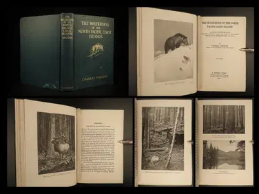
1912 HUNTING Alaska Vancouver Sheldon Wilderness of North Pacific Canada BearSchilb Antiquarian Rare Books4.8(422)See Sold PriceMar 31, 2024
[SHIPWRECKS]. Manuscript testimony (court duplicate) of Thomas Kent, a Black man aboard theFreeman's | Hindman4.4(1.6k)See Sold PriceFeb 27, 2024
Arrowsmith & Lewis - Map of PolynesiaTrillium Antique Prints & Rare Books4.5(30)See Sold PriceFeb 24, 2024
Arrowsmith & Lewis - Map of North AmericaTrillium Antique Prints & Rare Books4.5(30)See Sold PriceFeb 24, 2024
Arrowsmith & Lewis - Map of the World on Mercator's ProjectionTrillium Antique Prints & Rare Books4.5(30)See Sold PriceFeb 24, 2024
Arrowsmith & Lewis - Map of LouisianaTrillium Antique Prints & Rare Books4.5(30)See Sold PriceFeb 24, 2024
Arrowsmith & Lewis - Map of the United StatesTrillium Antique Prints & Rare Books4.5(30)See Sold PriceFeb 24, 2024
West Indies. South Coast of Jamaica from Port Royal to Pedro Bluff.Jasper524.5(9.8k)See Sold PriceFeb 27, 2024
Southern Africa Cape of Good Hope-Madagascar ADMIRALTY sea chart 1935 (1955) mapJasper524.5(9.8k)See Sold PriceFeb 28, 2024
Gulf of Guinea. Ghana Togo Benin Nigeria. ADMIRALTY sea chart 1928 (1954) mapJasper524.5(9.8k)See Sold PriceFeb 28, 2024
South Namibia coast. Walvis Bay-Orange River ADMIRALTY sea chart 1881 (1954) mapJasper524.5(9.8k)See Sold PriceFeb 28, 2024
Chart: United States- East Coast/ NORTH CAROLINA/ RIVER INLET TO CAPE FEAR.Churchill Galleries3.7(216)See Sold PriceFeb 26, 2024


![[SHIPWRECKS]. Manuscript testimony (court duplicate) of Thomas Kent, a Black man aboard the (1 of 5)](https://p1.liveauctioneers.com/197/319238/171468014_1_x.jpg?height=282&quality=70&version=1707520367)


