SoldRand McNally State & County Survey Atlas 1910Title/Content of Map: Rand McNally & Co.'s New Ideal State and County Survey Date Printed: 1910 Material/Medium: Bound Atlas Size: folio, approx. 12x14 inches 1st. edition. Illustrated with colored maSee Sold Price
New Ideal State and County Survey and Atlas of PennsylvaniaPublication Date: 1912 Title: New Ideal State and County Survey and Atlas of Pennsylvania Primary Authors: RAND MCNALLY & CO Publisher: RAND MCNALLY & CO Special subscription issue. 4to, XXX,25-154 p.See Sold Price
SoldGroup of 18 pieces assorted antique and vintage (earlyNeedlecraft, The New Ladies Home Journal, 1911 Rand McNally New Ideal State and County Survey and Atlas, and more. Largest is 12x14.25 inchesSee Sold Price
Rand, McNally & Co.'S New Ideal State and Country Survey And AtlasPublication Date: 1913 Title: Rand, McNally & Co.'S New Ideal State and Country Survey And Atlas Primary Authors: RAND, MCNALLY & CO Publisher: RAND, MCNALLY & CO Special Subscription edition. [PENNSYSee Sold Price
Rand, McNally & Co.'S New Ideal State and Country Survey And AtlasPublication Date: 1913 Title: Rand, McNally & Co.'S New Ideal State and Country Survey And Atlas Primary Authors: RAND, MCNALLY & CO Publisher: RAND, MCNALLY & CO Special subscription edition. PENNSYLSee Sold Price
SoldBox of atlases and other itemsHeading: (Atlases, etc.) Author: Title: Approx. 9 atlases, etc. Place Published: Publisher: Date Published: Description: Includes: Rand McNally,See Sold Price
SoldRAND MCNALLY 1909 STATE & COUNTY SURVEY AND ATLASRand McNally & Company 1909 New Ideal State and County survey and Atlas hardcover book, copyrighted in 1909 this atlas contains state county lines as well as astronomical data and other text as well aSee Sold Price
Rand, McNally & Co.'S New Ideal State and CountryTitle/Content of Map: Rand, McNally & Co.'S New Ideal State and Country Survey And Atlas Date: 1913 Cartographer: RAND, MCNALLY & CO Publisher: RAND, MCNALLY & CO Size: 14"H x 11.5"W Special subscriptSee Sold Price
Rand, McNally & Co.'S New Ideal State and CountryTitle/Content of Map: Rand, McNally & Co.'S New Ideal State and Country Survey And Atlas Date: 1913 Cartographer: RAND, MCNALLY & CO Publisher: RAND, MCNALLY & CO Size: 14.3"H x 11.4"W Special SubscriSee Sold Price
Sold13 Atlases. Early 20th century.[Atlases] 13 hardcover atlases. Mostly 4to and folio size. (1) “The Times Atlas.” 1895. (2) “New Ideal State and County Survey and Atlas.” Rand McNally, 1911. (3) “HammonSee Sold Price
SoldRand, McNally & Co.'s New Handy Atlas ContainingTitle/Content of Map: Rand, McNally & Co.'s New Handy Atlas Containing Colored County Maps of the United States And the Dominion of Canada Date: 1893 Cartographer: RAND, MCNALLY & CO Publisher: RAND,See Sold Price
Rand, McNally & Co.'S New Pocket AtlasTitle:Rand, McNally & Co.'S New Pocket Atlas Author: RAND, MCNALLY & CO Publisher/Maker: RAND, MCNALLY & CO Publication Date: 1893 Description: containing colored county maps of all states and territoSee Sold Price
Rand McNally: Antique Railroad Map of the United StatesTitle/Content of Map: Rand McNally & Co.'s New Railroad and County Map of the United States And Dominion of Canada Date Printed: 1882 Cartographer: RAND, MCNALLY & CO. Size: 26.5X44 Some fold repairs.See Sold Price
SoldAN ANTIQUE MAP, "Rand McNally & Co.'s New EnlargedAN ANTIQUE MAP, "Rand McNally & Co.'s New Enlarged Scale Railroad and County Map of Texas, Showing Every Railroad Station and Post Office in the State," CHICAGO, CIRCA 1885, color cerography on paper,See Sold Price
Washington state indexed shippers' maps, 1919Heading: (Washington) Author: Title: Rand, McNally & Co.'s indexed county and township pocket map and shippers' guide of Washington :accompanied by a new and original compilation and ready referenceSee Sold Price
SoldRand McNally & Co's State & Counry Survey Atlas$18 Shipping/handling/insurance (up to 100) shipped in the continental United States. We do not combine shipping as the packages are sealed and labeled immediately after the item is sold. InternationaSee Sold Price
Rand, McNally & Co.'S New Business Atlas Map of Boston.Title: Rand, McNally & Co.'S New Business Atlas Map of Boston. Publication Date: 1911 Cartographer: RAND, MCNALLY & CO. Publisher: RAND, MCNALLY & CO. Dimensions: 26 X 19 Additional Information: PageSee Sold Price
SoldUnion of South Africa Map by Rand McNally c. 1911This is an original tinted early map by Rand McNally of the Union of South Africa. The piece is from circa 1911. Marked, "Union of South Africa", "Rand, McNally & Co.'s New Business Atlas Map of UnionSee Sold Price
Rand, McNally & Co.'s New Business Atlas Map ofTitle: Rand, McNally & Co.'s New Business Atlas Map of Chicago. Railway Terminal Map of Chicago. Publication Date: 1911 Cartographer: RAND, MCNALLY & CO. Publisher: RAND, MCNALLY & CO. Dimensions: 26See Sold Price
SoldGroup of Early Maps of New Mexico(1) Rand, McNally & Co.'s New Commercial Atlas of America - Map of New Mexico. Copyright, 1911, by Rand, McNally & Co. 23 3/4 x 31 1/4 inches (2) Geologic Map of New Mexico. Two-part folding map. PartSee Sold Price
Indianapolis and Environs. Rand, McNally & Co's NewTitle: Indianapolis and Environs. Rand, McNally & Co's New Business Atlas of America Map of Indianapolis. Publication Date: 1911 Cartographer: RAND, MCNALLY & CO. Publisher: RAND, MCNALLY & CO. DimensSee Sold Price
SoldRand McNally NEW DOLLAR ATLAS 1884 U.S. & CanadaTitle: Rand, McNally & Co.'s New Dollar Atlas of the United States and Dominion of Canada Publisher: Continental Publishing Co. Printing Year: 1884 Condition/Details: Bound in decorative hardcover, tSee Sold Price
SoldRand McNally & Co.'s New Railroad and County Map of theTitle/Content of Map: Rand McNally & Co.'s New Railroad and County Map of the United States And Dominion of Canada Date: 1882 Cartographer: RAND, MCNALLY & CO. Publisher: RAND, MCNALLY & CO. Size: 26.See Sold Price
SoldRand, McNally and CoRand, McNally and Co.'s New Enlarged Scale Railroad and County map of California, 1887, Provenance: John Howell Books, SFSee Sold Price
Rand McNally/Santa Fe Railroad Map of Iowa-1912JM Hobby Supply and Railroad Artifact Auctions4.4(127)See Sold PriceFeb 24, 2024
Charles Lundgren (NY,CT,1911-1988) oil paintingBroward Auction Gallery4.7(292)See Sold PriceMar 17, 2024
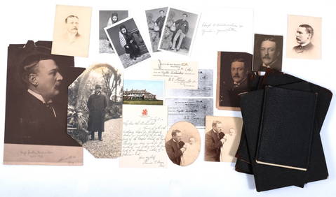
HUGH D. AUCHINCLOSS I (1858-1913) IN MEMORIAMJohn McInnis Auctioneers,LLC4.5(505)See Sold PriceFeb 25, 2024
Rand McNally Railroad Map Cabinet w/ 21 Railroad MapsRail & Road Auctions4.6(165)See Sold PriceMar 08, 2024
Rand McNally & Co's New Ideal State and County Survey and Atlas 1911North American Artifact Auctions4.7(198)See Sold PriceApr 20, 2024
10PC 1978 Kenner Star Wars Group incl. DT LukeBruneau & Co. Auctioneers4.5(491)See Sold PriceFeb 24, 2024
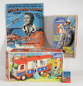
4PC 1973 Evel Knievel Ideal Cycle Van Poster GroupBruneau & Co. Auctioneers4.5(491)See Sold PriceFeb 24, 2024
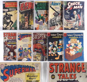
10PC Atlas DC Dell Golden Silver Age Comics GroupBruneau & Co. Auctioneers4.5(491)See Sold PriceFeb 24, 2024
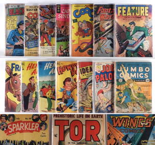
21PC Fiction House Quality Dell Golden Age ComicsBruneau & Co. Auctioneers4.5(491)See Sold PriceFeb 24, 2024
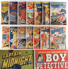
32PC Estate Fresh Golden Age Crime Hero GroupBruneau & Co. Auctioneers4.5(491)See Sold PriceFeb 24, 2024
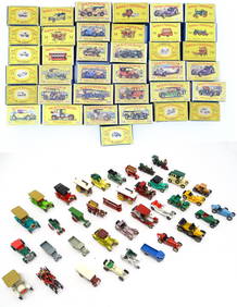
Toys: A quantity of assorted die cast scale model Matchbox Models of Yesteryear by Lesney to includeClaydon Auctioneers Ltd4.3(125)See Sold PriceFeb 26, 2024
ART DECO STEUBEN GLASS COMPOTE BY FREDRICK CARDERAntique Arena Inc.4.5(878)See Sold PriceMar 02, 2024
West Indies. Rand, McNally & Co.'S Indexed Atlas Map of the West Indies.Jasper524.5(9.9k)See Sold PriceFeb 27, 2024
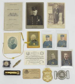
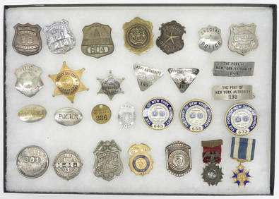
28PC Collection of New York City Police BadgesBruneau & Co. Auctioneers4.5(491)See Sold PriceMar 18, 2024
New Concise Dictionary Thesaurus Hardcover Book Set 1986Rapid Estate Liquidators and Auction Gallery4.5(1.1k)See Sold PriceMar 03, 2024


![[Ambrotype] Identified Tennessee Soldier (1 of 3)](https://p1.liveauctioneers.com/7226/317626/170485496_1_x.jpg?height=282&quality=70&version=1706368022)