SoldTWO 19TH CENTURY GEORGETOWN MAPSOne is downtown street map with residences - "Georgetown Subscribers Business Directory" & the other the entire town with residences, handwritten "1872" in pencil on the bottom. Both are framed in midSee Sold Price
SoldBoston Pocket Business Directory 1862Dudley, Dean, comp. Description:233, [1] pp. Advertisements inserted throughout; folding map. (16mo) 6¼x4, original blindstamped brown cloth lettered in gilt. First Edition. Scarce 19th century BostoSee Sold Price
SoldHand-Colored 19th Century United States Maps(Lot of 34) Assorted hand-colored 19th century United States maps, (4) Various San Francisco historical business documents, (19) Assorted prints from publications depicting history and geography of thSee Sold Price
SoldLot of Seven Framed and Unframed Prints, includingLot of Seven Framed and Unframed Prints, including a 19th century map titled Modern Palestine on the Basis of Kiepert with the Latest Corrections, a Japanese woodblock print, an offset print BloodhounSee Sold Price
19th Century Map Print Collection19th Century Map Print Collection Includes forty-two loose maps cut from German and English books Height: 16.50 inches, Width: 11.00 inches (dimensions of Assyrian map) Category: Decorative Arts > EtcSee Sold Price
Sold1904 ATLAS ONTARIO CO. NY BY CENTURY MAP CO.1904 ATLAS ONTARIO CO. NY BY CENTURY MAP CO. 84 PAGES OF HAND COLORED MAP PLATES. INCL. A RECORD OF THE SOME OF MOST VALUABLE & PRODUCTIVE FARMS, BUSINESS DIRECTORY. CENTURY MAP CO., PHILADELPHIA, 190See Sold Price
SoldNine misc. 19th century prints, including maps, bNine misc. 19th century prints, including maps, botanical, fruit; some stains and ripsSee Sold Price
SoldThirteen Early Maps, 19th Century Prints, and Centennial Program.Thirteen Early Maps, 19th Century Prints, and Centennial Program. Map, T.C. Holm, Christianae Skantz och Staden Christinae Hamns, Stockholm, 1702. Ht. 7 1/4, wd. 5 1/2 in. Map, T.C. Holm, Trefall dighSee Sold Price
Sold19th Century Maps and Print (6pc)Four antique hand colored city maps, a map of Hungary, and one print: 'View of Frankfort, from Saschsenhausen', W.B. Clarke, Arch. Published by Baldwin & Cradock, 1837. Measures 13.5" H x 16" W (waterSee Sold Price
SoldA Seventeen-Piece Collection of Various PrintsA Seventeen-Piece Collection of Various Prints, late 19th/20th century, comprised of maps, architectural prints and three pages from the 1885 Frank Leslie's Illustrated Newspaper regarding the art galSee Sold Price
SoldA Seventeen-Piece Collection of Various PrintsA Seventeen-Piece Collection of Various Prints, late 19th/20th century, comprised of maps, architectural prints and three pages from the 1885 Frank Leslie's Illustrated Newspaper regarding the art galSee Sold Price
Sold19th century French bookplates(lot of 23) Unframed prints, including 19th Century French bookplates of maps and plans, botanical prints (some matted), etc.; largest overall: 18'' x 10''See Sold Price
SoldFour Washington D.C. Related Maps & Prints ca. 19th CenturyGroup of four Washington D.C. related maps & prints, ca. mid to late 19th century. Frame size of "Map of Washington. District of Columbia." are 10 1/2" H x 11 1/2" W x 3/8" D.See Sold Price
Sold19TH CENTURY HANDCOLORED PRINT, MAP OF ENGLAND 1919TH CENTURY HANDCOLORED PRINT, MAP OF ENGLAND 19 1/2" X 15"See Sold Price
SoldA Collection of Naval Prints.A Collection of Naval Prints. Six French 19th century charts and a map Larger: 29.5" x 42"See Sold Price
SoldBox Lot of ArtVarious prints, works on paper, other art. Includes Hogarth, botanicals, yachting, 4 19th century ethnographic prints, map, architecturals, U.S. Capitol, human skull etc.See Sold Price
SoldFive Framed 19th Century Prints and New England MaFive Framed 19th Century Prints and New England Maps, a giltwood framed James Heath engraving General Washington; a P.F. Tardieu Carte de la Partie Septentrionale des Etats-Unis; an 1826 M. Swett, PenSee Sold Price
SoldSix Prints/Maps of New Orleans & the MississippiCollection of Six Late 19th/20th-Century Prints and Maps of Historic New Orleans and the Mississippi including "View of New Orleans from Algiers Point", color print lithograph after Th. Mueller's 1851See Sold Price
SoldVictorian Walnut Folio StandBritish or American, late 19th century, the map or print supports with ring-and-baluster turned ratcheted adjustable supports on a trestle-form base, 47-1/4 x 30-1/2 x 21-1/2 in. scattered light surfaSee Sold Price
SoldThree 19th Century Maps of New YorkGroup Lot of 3 New York Maps 1. Map of the City of New York, 1852. D. T. Valentine (1801 - 1869). New York: Hayward, 1852. Lithograph. Dimensions. 2. Plan of the City of New-York, drawn by Major HollaSee Sold Price
(9) Assorted 19th Century Maps w/ Hand ColoringCollection of nine (9) assorted 19th Century maps with hand coloring, New York Lithograph engraving and printing Company, 16 Park Place, New York, New York. Including: Italia, Roma, Assyria, Empire ofSee Sold Price
(8) Assorted 19th Century Maps w/ Hand ColoringCollection of eight (8) assorted 19th Century maps with hand coloring, New York Lithograph engraving and printing Company, 16 Park Place, New York, New York. Including: Italia, Roma, Assyria, Empire oSee Sold Price
Sold(13) Assorted 19th Century Maps w/ Hand ColoringCollection of thirteen (13) assorted 19th Century maps with hand coloring, New York Lithograph engraving and printing Company, 16 Park Place, New York, New York. Including: Italia, Roma, Assyria, PartSee Sold Price
Mitchell - Map of the City of Washington (Washington, DC)Trillium Antique Prints & Rare Books4.5(32)See Sold PriceFeb 24, 2024
Pre-colonial Africa. Mountains of Kong/Moon. Caravan routes. THOMSON 1817 mapJasper524.5(9.9k)See Sold PriceFeb 28, 2024
COLONIES FRANÇAISES en AFRIQUE. Africa Sénégal Madagascar. LEVASSEUR c1850 mapJasper524.5(9.9k)See Sold PriceFeb 28, 2024
Johnson's Africa. Colonies & tribes. Liberia Nile Delta Cape Colony 1866 mapJasper524.5(9.9k)See Sold PriceFeb 28, 2024
West Africa. Sahara caravan routes. Tribes Kingdoms Empires. LIZARS 1842 mapJasper524.5(9.9k)See Sold PriceFeb 28, 2024
Afrique Ancienne. Ancient North Africa. MALTE-BRUN c1871 old antique map chartJasper524.5(9.9k)See Sold PriceFeb 28, 2024
James Sowerby (1757 - 1822) - Set of 10 Botanical Prints - Orobanche Common Lesser - CentrolepisProverde Auctions4.3(3)See Sold PriceFeb 28, 2024
Charles Antoine Lemaire (1800 - 1871) - Set of 4 Botanical Prints - Rose - Camellia Duchesse deProverde Auctions4.3(3)See Sold PriceFeb 28, 2024
Charles Antoine Lemaire (1800 - 1871) - Set of 4 Botanical Prints - Brassavola fragias - BerberioProverde Auctions4.3(3)See Sold PriceFeb 28, 2024
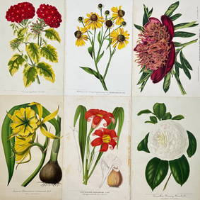
Charles Antoine Lemaire (1800 - 1871) - Set of 6 Botanical Prints - Ismene amancaes - Camellia FannyProverde Auctions4.3(3)See Sold PriceFeb 28, 2024
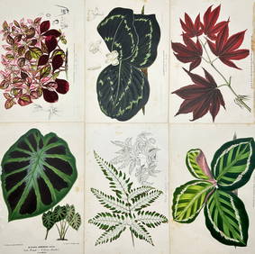
Charles Antoine Lemaire (1800 - 1871) - Set of 6 Botanical Prints - Alocasia - Calathea roseopicta -Proverde Auctions4.3(3)See Sold PriceFeb 28, 2024
Charles Antoine Lemaire (1800 - 1871) - Set of 8 Botanical Prints - Alstraemeria Argento - CayaponiaProverde Auctions4.3(3)See Sold PriceFeb 28, 2024
Charles Antoine Lemaire (1800 - 1871) - Set of 8 Botanical Prints - Embothrium coccineum -Proverde Auctions4.3(3)See Sold PriceFeb 28, 2024
Jules de Liron d’Airoles (1802 - 1882) - Antique Fruit Print of Pond's Seedling PlumProverde Auctions4.3(3)See Sold PriceFeb 28, 2024
Joseph Meyer - Set of 50 Prints - Views of Austria - Germany - Italy - Sweden - France - CzechProverde Auctions4.3(3)See Sold PriceFeb 28, 2024
Joseph Meyer - Set of 50 Prints - Views of Austria - Germany - Italy - Sweden - France - UnitedProverde Auctions4.3(3)See Sold PriceFeb 28, 2024
Francis McNally - Antique Map of Nebraska, Kansas, Dakota, Colorado & MontanaProverde Auctions4.3(3)See Sold PriceFeb 28, 2024
Francis McNally - Antique Map of California & MinnesotaProverde Auctions4.3(3)See Sold PriceFeb 28, 2024
Francis McNally - Antique Map of Ohio, Indiana & KentuckyProverde Auctions4.3(3)See Sold PriceFeb 28, 2024
Francis McNally - Antique Map of Washington, Oregon, Idaho, Nevada, Utah & ArizonaProverde Auctions4.3(3)See Sold PriceFeb 28, 2024