Claude Monet French 1840 - 1926 Oil on canvas Painting Impressionism Renoir Manet Pissarro Era.International Art Auction Gallery4.4(166)See Sold PriceFeb 24, 2024
Antique American Hudson River School Sunset Landscape Framed Original Oil PaintingCurated Gallery Auctions4.6(138)See Sold PriceFeb 25, 2024
Robert William Wood (1889 - 1979) Texas BluebonnetsPremier Auction Galleries4.3(338)See Sold PriceMar 09, 2024
BIRGER SANDZEN (1871-1954) COLORADO OIL ON CANVAS 1936Soulis Auctions4.8(958)See Sold PriceFeb 24, 2024
George Adomeit (American 1879-1964) CAPE COD LandscapePremier Auction Galleries4.3(338)See Sold PriceMar 09, 2024
Vincent Van Gogh Dutch 1853-1890 Oil on canvas. Paul Gaugin, Cezanne, Degas EraInternational Art Auction Gallery4.4(166)See Sold PriceFeb 24, 2024
Renaissance Old Master Altarpiece Adoration Magi Oil Painting Christ Child Virgin Mary Wise MenHess Fine Auctions4.5(213)See Sold PriceMar 02, 2024
19TH C GERMAN OIL PAINTING BY EMIL ZSCHIMMER C 1872Antique Arena Inc.4.5(883)See Sold PriceFeb 24, 2024
JOHN CONSTABLE ANTIQUE ENGLISH CLOUDS OIL PAINTINGAntique Arena Inc.4.5(883)See Sold PriceFeb 24, 2024
ATTRIBUTED TO GILBERT STUART (MA/RI/UK, 1755-1828)Thomaston Place Auction Galleries4.4(394)See Sold PriceFeb 24, 2024
Pablo Picasso Spanish 1881-1973 Oil On Canvas Painting Dali Magritte Braque Juan GrisInternational Art Auction Gallery4.4(166)See Sold PriceFeb 24, 2024
ATTRIB Francisco Miralles Y Galup (Spain,France,1848-1901) oil painting antiqueBroward Auction Gallery4.7(300)See Sold PriceMar 10, 2024
AMERICAN SCHOOL (Early 20th c) Two WorksJohn McInnis Auctioneers,LLC4.5(505)See Sold PriceFeb 25, 2024
Marc Chagall-Limited Edition -Paris Opera Ceiling after ChagallArt Legacy Auctions4.5(225)See Sold PriceFeb 24, 2024
SoldPreuss' Topographical Map on 7 sheets 1846Heading: Author: Preuss, Charles Title: Topographical Map of the Road from Missouri to Oregon, Commencing at the Mouth of the Kansas in the Missouri River and Ending at the Mouth of the Wallah WallahSee Sold Price
SoldPreuss' Topographical Map on 7 sheets 1846Title: Topographical Map of the Road from Missouri to Oregon, Commencing at the Mouth of the Kansas in the Missouri River and Ending at the Mouth of the Wallah Wallah in the Columbia, In VII Sections.See Sold Price
SoldPreuss' Topographical Map on 7 sheets 1846Title: Topographical Map of the Road from Missouri to Oregon, Commencing at the Mouth of the Kansas in the Missouri River and Ending at the Mouth of the Wallah Wallah in the Columbia, In VII Sections.See Sold Price
SoldTOPOGRAPHICAL MAP OF THE ROAD... 7 Sheets. 1846.[United States/Exploration]. TOPOGRAPHICAL MAP OF THE ROAD FROM MISSOURI TO OREGON… Commencing at the Mouth of the Kansas in the Missouri River and Ending at the Mouth of the Wallah-Wallah in the CoSee Sold Price
SoldPreuss map Oregon Road in 7 sheets 1849Heading: Author: Preuss, Charles Title: Topographical Map of the Road from Missouri to Oregon, Commencing at the Mouth of the Kansas in the Missouri River and Ending at the Mouth of the Wallah WallahSee Sold Price
SoldPreuss map Oregon Road in 7 sheets 1849Title: Topographical Map of the Road from Missouri to Oregon, Commencing at the Mouth of the Kansas in the Missouri River and Ending at the Mouth of the Wallah Wallah in the Columbia, In VII Sections.See Sold Price
SoldPreuss map Oregon Road in 7 sheets 1849Title: Topographical Map of the Road from Missouri to Oregon, Commencing at the Mouth of the Kansas in the Missouri River and Ending at the Mouth of the Wallah Wallah in the Columbia, In VII Sections.See Sold Price
SoldPREUSS, CHARLES. Topographical Map of the RoadPREUSS, CHARLES. Topographical Map of the Road from Missouri to Oregon. Group of 5 (of 7) lithographed maps, each 380x615 mm [as issued]; scattered minor soiling and extraneous creases; each with brieSee Sold Price
BRITISH MAP OF TROARN, NORMANDYBRITISH MAP OF TROARN, NORMANDY British topographical military map of the region about Troarn, France, 31" x 21", a 1: 50,000 scale map labeled at top: "TROARN SHEET 7 F/2" and is the second revision,See Sold Price
Sold[Map] Preuss & Fremont, Oregon Trail, 1846Charles Preuss and J. C. Fremont - "Topographical Map of the Road from Missouri to Oregon … in VII Sections" (Washington, by order of the Senate, printed in Baltimore by E. Weber, 1846) seven liSee Sold Price
SoldTopographical Map - Road from Missouri to OregonTopographical Map of the Road from Missouri to Oregon compiled by Charles Preuss, 1846 Lithograph E. Leber Section - II, III, IV, V, VISee Sold Price
SoldU. S. Geographical... Topographical Atlas Sheets.[Natural History/Geology] U. S. GEOGRAPHICAL SURVEYS WEST OF 100th MERIDIAN: TOPOGRAPHICAL ATLAS SHEETS. Wheeler. 1876. Atlas is 7 folding maps in ¼ cloth and printed paper covered board. Maps mostlySee Sold Price
SoldRoad from Missouri to Oregon topographical mapsTopographical Maps of the Road from Missouri to Oregon in Seven Sections, 1846. Compiled by Charles Preuss, Assistant to John C. Fremont. Scale 10 miles to the inch. This series of seven maps accompanSee Sold Price
SoldLithograph Map of the Territory of New MexicoMap of the Territory of New Mexico. U.S. Army Corps of Engineers. Lithographed map. Washington, D.C.: C.B. Graham, 1846-7. 27 1/4 X 22 1/2 inches sheetSee Sold Price
SoldPreuss, Topographical Map of the Road…."Frémont's and Preuss' greatest contributions to the development of the West"-Goetzmann 118. [MAP]. PREUSS, Charles. Topographical Map of the Road from Missouri to Oregon Commencing aSee Sold Price
SoldAN ANTIQUE MAP, "General Topographical Map, SheetAN ANTIQUE MAP, "General Topographical Map, Sheet XXII," WASHINGTON D.C., 1891-1895, lithograph on paper, from Atlas to Accompany the Official Records of the Union and Confederate Armies, plate CLVII,See Sold Price
Sold6 Maps (7 Sheets): 3 by Jaillot, 1709-20 + others.[Europe/Atlantic]. 6 Maps on 7 Sheets. Largest: 18 1/8” x 30 ¼”. Smallest: 21 ¾” x 16 7/8”. Sold with all faults. Most have early hand-colored outline. ++ Le Comte De Haynaut, Divise en ChatSee Sold Price
General Topographical Map. Sheet XWAR DEPARTMENT, U.S. ARMY. CORPS OF ENGINEERS, 1893, Folio – 16.50 H x 27.30 W Inches, Plate CXLV from the Atlas to Accompany the Official Records of the Union and Confederate Armies. 1861-1865. TheSee Sold Price
General Topographical Map. Sheet XV.WAR DEPARTMENT, U.S. ARMY. CORPS OF ENGINEERS., 1893, Folio – 18.50 H x 29.50 W Inches, Plate CL from the Atlas to accompany the Official Records of the Union and Confederate armies, 1861-1865. CentSee Sold Price
General Topographical Map Sheet XXIIIWAR DEPARTMENT, U.S. ARMY. CORPS OF ENGINEERS., 1892, Double Folio – 16.00 H x 27.50 W Inches, From the Atlas to accompany the Official Records of the Union and Confederate armies, 1861-1865. Map shSee Sold Price
General Topographical Map. Sheet Ix.Title/Content of Map: General Topographical Map. Sheet Ix. Cartographer: U.S. ARMY. CORPS OF ENGINEERS Date: 1893 Publisher: WAR DEPARTMENT Size: 16.5Height - 27.3Width Plate CXLIV from the Atlas to ASee Sold Price
General Topographical Map. Sheet XIIPublication Date: 1893 Title: General Topographical Map. Sheet XII Cartographer: U.S. ARMY. CORPS OF ENGINEERS Publisher: WAR DEPARTMENT Height: 16.3 Width: 27.3 Plate CXLVII from the Atlas to AccompaSee Sold Price
General Topographical Map Sheet XXIII.Publication Date: 1893 Title: General Topographical Map Sheet XXIII. Cartographer: U.S. ARMY. CORPS OF ENGINEERS. Publisher: WAR DEPARTMENT Height: 16.5 Width: 27.5 Plate CLVIII from the Atlas to AccoSee Sold Price
General Topographical Map. Sheet XXV.Publication Date: 1893 Title: General Topographical Map. Sheet XXV. Cartographer: U.S. ARMY. CORPS OF ENGINEERS. Publisher: WAR DEPARTMENT Height: 18.5 Width: 29 Plate CLX from the Atlas to accompanySee Sold Price
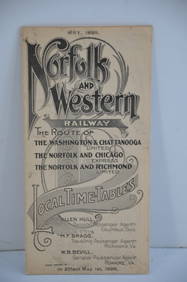
Norfolk and Western RY May 1898 Public TimetableJM Hobby Supply and Railroad Artifact Auctions4.4(127)See Sold PriceFeb 24, 2024
EARLY 18TH C. DUTCH CHART OF PACIFIC OCEAN BY FREDERIK DE WIT (1629-1706) WITH CALIFORNIA AS ANThomaston Place Auction Galleries4.4(394)See Sold PriceFeb 24, 2024
18th Century Hess Germany Hand colored Engraved MapGlobal Auctions Company4.3(36)See Sold PriceMar 03, 2024
Group of 15 Printed or Lithographed Items, including: litho...Potter & Potter Auctions4.6(550)See Sold PriceMar 07, 2024
Kunstgewerbliche Schmuckformen fur die Flache, Pochoir PlateCatalog Projects4.5(61)See Sold PriceFeb 28, 2024
Robert Kipniss, "Landscape with Window & Chair"Old Kinderhook Auction Company4.6(217)See Sold PriceMar 05, 2024
1834 Malte-Brun Map of the Caribbean -- West India IslandsJasper524.5(9.9k)See Sold PriceFeb 27, 2024
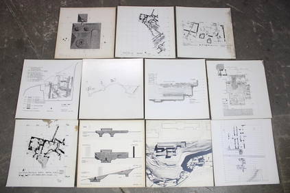
Set of 11 Mid Century Modern Architectural Plans & Site Map RenderingsPUBLIC SALE4.7(227)See Sold PriceMar 02, 2024
Herman Moll A New Map of Ye North Parts of AmericaWillow Auction House4.5(292)See Sold PriceMar 14, 2024


![[Map] Preuss & Fremont, Oregon Trail, 1846 (1 of 3)](https://p1.liveauctioneers.com/523/81971/42494509_1_x.jpg?height=282&quality=70&version=1447274451)