Marc Chagall-Limited Edition -Paris Opera Ceiling after ChagallArt Legacy Auctions4.5(223)See Sold PriceFeb 24, 2024
Salvador Dali Pantagruel Limited Edition Lithograph Hand signed and numberedArt Legacy Auctions4.5(223)See Sold PriceFeb 24, 2024
Pablo Picasso Bouquet of Peace Collection Domaine Picasso Limited Edition on paper.Art Legacy Auctions4.5(223)See Sold PriceFeb 24, 2024
A RARE MAXFIELD PARRISH JACK AND THE BEANSTALK PRINTSoulis Auctions4.8(953)See Sold PriceFeb 24, 2024
LARGE MECHANICAL PRINT 'STARS' AFTER MAXFIELD PARRISHSoulis Auctions4.8(953)See Sold PriceFeb 24, 2024
Heinrich Aldegrever, etc. 15 old master prints. 16th-17th centuries. Aldegrever works include "ManTremont Auctions4.5(297)See Sold PriceFeb 25, 2024
Pelton's 1854 Political & Physical Map of the EasternHand colored lithograph laid on canvas, with ebonized lower dowel for rolling storage. Published by Sower & Barnes, Philadelphia. 80" x 75".See Sold Price
Sold1854 PELTON'S WALL MAP OF WESTERN HEMISPHEREFull title being : “Pelton’s Political and Physical Map of the Western Hemisphere.: published by Sower & Barnes, Philadelphia. Hand colored laid on linen, 80” square, with lower wooden dowel.See Sold Price
SoldBartholomew, John 1922 Lot of 4 Maps of EuropeIncl Europe Political, Eastern Europe Political, Western Europe Political, and Europe Physical Features & Population. Large Lithograph Maps Published 1922 by The Times, London for "The Times Survey AtSee Sold Price
Bartholomew, John 1922 Lot of 4 Maps of EuropeIncl Europe Political, Eastern Europe Political, Western Europe Political, and Europe Physical Features & Population. Large Lithograph Maps Published 1922 by The Times, London for "The Times Survey AtSee Sold Price
Bartholomew, John 1922 Lot of 4 Maps of EuropeIncl Europe Political, Eastern Europe Political, Western Europe Political, and Europe Physical Features & Population. Large Lithograph Maps Published 1922 by The Times, London for "The Times Survey AtSee Sold Price
Ranally Physical-Political Eastern HemisphereTitle: Ranally Physical-Political Eastern Hemisphere Cartographer: RAND MCNALLY & COMPANY Date: 09 01 1934 Publisher: RAND MCNALLY & COMPANY Size: 54.75Height - 39Width Additional Info: Schoolroom mapSee Sold Price
SoldHale's Kanzas and Nebraska 1854 with mapHeading: Author: Hale, Edward Everett Title: Kanzas and Nebraska: The History, Geographical and Physical Characteristics, and Political Position of Those Territories; an Account of the Emigrant Aid CSee Sold Price
SoldHale's Kanzas and Nebraska 1854 with mapHeading: Author: Hale, Edward Everett Title: Kanzas and Nebraska: The History, Geographical and Physical Characteristics, and Political Position of Those Territories; an Account of the Emigrant Aid CSee Sold Price
SoldKanzas and Nebraska 1854 with mapHeading: Author: Hale, Edward Everett Title: Kanzas and Nebraska: The History, Geographical and Physical Characteristics, and Political Position of Those Territories; an Account of the Emigrant Aid CSee Sold Price
SoldHale's Kanzas & Nebraska with map 1854Title: Kanzas and Nebraska: The History, Geographical and Physical Characteristics, and Political Position of Those Territories; an Account of the Emigrant Aid Companies, and Directions to Emigrants ASee Sold Price
SoldHale's Kanzas & Nebraska with map 1854Title: Kanzas and Nebraska: The History, Geographical and Physical Characteristics, and Political Position of Those Territories; an Account of the Emigrant Aid Companies, and Directions to Emigrants ASee Sold Price
SoldNew Edition Loose Leaf AtlasNew edition loose leaf Atlas, by C.S. Hammond & Co., new & complete historical economic, political & physical maps with complete indexes, fifth edition (1924), full color maps of the world & US statesSee Sold Price
Political and physical map of South America. 1871.Print from steel engraving titled „Carte physique et politique de L‘Amerique du Sud“.Author/compiler - MM. Drioux et Ch. Leroy.Engraved by Jenotte.Notes: 28 et 29/74. 75.From „Atlas universelSee Sold Price
Map of the North America. 1871.Political and physical map of the North America. 1871.Print from steel engraving titled „Carte physique et politique de L‘Amerique du Nord“.Author/compiler - MM. Drioux et Ch. Leroy.Engraved bySee Sold Price
SoldHAMMONDS NEW WORLD ATLAS ANTIQUE BOOKCopyright Doubleday / Doran INc. 1936. Containing new and complete historical, economic and political and physical maps. Measures 20 1/2" tall by 13 3/4" wide and 1 1/2" deep. Small wear to spine at tSee Sold Price
SoldVintage Crams Physical Political Map of the WorldVintage Crams Physical Political Map of the World C-69. Used condition, wear, worn. 67 1/2" wideSee Sold Price
Cram's Physical-Political Map of Europe...Title: Cram's Physical-Political Map of Europe... Date: 1974 Cartographer: CRAM, GEORGE F. COMPANY, INC. Publisher: THE GEORGE F. CRAM COMPANY, INC. Size: 36Height - 55Width Wall map on spring roller,See Sold Price
Cram's Physical-Political Map of AustralasiaTitle: Cram's Physical-Political Map of Australasia Date: c1972 Cartographer: CRAM, GEORGE F. COMPANY Publisher: THE GEORGE F.CRAM COMPANY, INC. Size: 37.3Height - 50.5Width Large schoolroom wall charSee Sold Price
Cram's Physical-Political Map of the WorldPublication Date: c1966 Title: Cram's Physical-Political Map of the World Cartographer: CRAM, GEORGE F. COMPANY, INC. Publisher: THE GEORGE F. CRAM COMPANY, INC. Height: 42.75 Width: 50.75 "ArmadilloSee Sold Price
Cram's Simplified Physical-Political Map of Africa...Title/Content of Map: Cram's Simplified Physical-Political Map of Africa... Cartographer: CRAM, THE GEORGE F. COMPANY, INC. Date: c1965 Publisher: THE GEORGE F. CRAM COMPANY, INC. Size: 42Height - 50.See Sold Price
BalkansTitle/Content of Map: Balkans Date: c1950 Cartographer: Publisher: Size: 59Height - 45Width Russian text. Bright physical/political map centering on Balkan area. Extending from Czechoslovakia to CreteSee Sold Price
China Physical-PoliticalTitle: China Physical-Political Publication Date: c1950 Cartographer: Publisher: Brief Description: text in Chinese. One faint tape repair, otherwise bright, colorful physical-political map. Scarce ChSee Sold Price
Chicago and Eastern Illinois RR Annual Reports-1878 to 1887JM Hobby Supply and Railroad Artifact Auctions4.4(127)See Sold PriceFeb 24, 2024
Cleveland and Mahoning RR 2nd Annual Report-December 20, 1854JM Hobby Supply and Railroad Artifact Auctions4.4(127)See Sold PriceFeb 24, 2024
Eastern RR Summer Book of Tours-1884JM Hobby Supply and Railroad Artifact Auctions4.4(127)See Sold PriceFeb 24, 2024
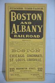
Boston and Albany RR March 17, 1881 Public TimetableJM Hobby Supply and Railroad Artifact Auctions4.4(127)See Sold PriceFeb 24, 2024
Nova Totius Full Color Geographical World MapThe Benefit Shop Foundation Inc.4.3(2.9k)See Sold PriceFeb 28, 2024
[SHEET MUSIC]. [THE “KNOW NOTHING” POLITICAL PARTY]. NICKS,...Potter & Potter Auctions4.6(545)See Sold PriceMar 07, 2024
De Jode, Rare, pub. 1593 - Map of the Middle East, Eastern Asia (Primae Partis Asiae accurataTrillium Antique Prints & Rare Books4.5(32)See Sold PriceFeb 24, 2024
VARIOUS ARTISTS [BRITISH TRAVEL GUIDES]. Group of 6 map booklets and flyers. 1930s.Swann Auction Galleries4.4(70)See Sold PriceFeb 29, 2024
1764 Bellin Map of Eastern Guadeloupe in the Lesser Antilles -- Partie Orientale de l'Isle de laJasper524.5(9.9k)See Sold PriceFeb 28, 2024
Mexico, Central America and West Indies Physical PoliticalJasper524.5(9.9k)See Sold PriceFeb 28, 2024
Perry, Matthew C. 1856 Large Map. Shah Bay, Lew Chew I. JapanAlbion Auctions4.6(341)See Sold PriceMar 01, 2024
ANTIQUE ILLUSTRATED HANDBOOK OF GEOGRAPHY AND TRAVEL IN ASIA, VOLUME 2, 1896NY Elizabeth 4.2(86)See Sold PriceMar 03, 2024
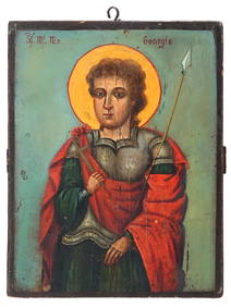
ANTIQUE 19TH C ORTHODOX ICON PAINTING OF ST GEORGEAntique Arena Inc.4.5(878)See Sold PriceMar 09, 2024
20 Pcs Vintage Ephemera incl Political Cigar BansCordier Auctions & Appraisals4.4(1.5k)See Sold PriceMar 02, 2024


![[SHEET MUSIC]. [THE “KNOW NOTHING” POLITICAL PARTY]. NICKS,... (1 of 2)](https://p1.liveauctioneers.com/928/318880/171361186_1_x.jpg?height=282&quality=70&version=1707501302)


![VARIOUS ARTISTS [BRITISH TRAVEL GUIDES]. Group of 6 map booklets and flyers. 1930s. (1 of 2)](https://p1.liveauctioneers.com/199/319703/171640571_1_x.jpg?height=282&quality=70&version=1707943705)