SoldPair of John Cary Mapsa new map of North America, a new map of part of the United States each 18" x 20" SHIPPING: Buyer is responsible for arranging 3rd party shipping. Also see 3rd party shipper list provided in SHIPPINGSee Sold Price
SoldCary, John 1787-90 Pair of Maps of Staffrodshire, UKHand Colored Copper Engraved Maps Published 1787, Lond for "Cary's New & Correct English Atlas" Together with a smaller Map of Staffordshire Published 1790, London for "Cary's Traveller's Companion" bSee Sold Price
John Cary (1754-1835) - Pair of coloured engravings -John Cary (1754-1835) - Pair of coloured engravings - Maps of 'South Wales' and 'North Wales', 8.25ins x 10.25ins, published by J. Cary, 1793, in modern wood frames and glazedSee Sold Price
SoldFirst Globe to show Travel's of Lewis & ClarkPair of English 21-inch celestial and terrestrial globes. John & William Cary (19th century). Globes on Regency mahogany stands. London: J. & W. Cary, dated 1799 and 1815 respectively. Height overallSee Sold Price
John Cary: Map of the Middle States, 1806Map: Middle States Maker: John Cary Date: 1806 Size: 30 x 30 inches Medium: Original copperplate engraving John Cary (1754-1835) was an English cartographer who is known for his maps, globes, and hisSee Sold Price
SoldJohn Cary, Map United States, Treaty of Peace 1783John Cary (London, 1754-1835) "An Accurate Map of the United States of America, with Part of the Surrounding Provinces agreeable to the Treaty of Peace of 1783", 1783 (created/published) Hand coloredSee Sold Price
John Cary: Map of the Russian Empire, 1799Map: A New Map of the Russian Empire, Divided into its Governments; from the Latest Authorities Maker: John Cary Date: 1799 Origin: London Size: 18 x 40 inches A magnificent map of the Russian EmpireSee Sold Price
John Cary maps of Yorkshire 1793Title: Lot four maps of Yorkshire Author: Cary, John Description: Includes: Part of the West Riding of Yorkshire. * Part of the West Riding of Yorkshire. (different than preceding.) * North Riding ofSee Sold Price
Sold1812 John Cary Map ofTitled "A New Map of Part of the United States of North America", published by J. Cary, London, 1812. There are a few small pinholes, and one small hole in the bottom center along the center fold.See Sold Price
SoldJohn Cary Map, "A New Map of China" 1801, hand coloredJohn Cary Map, "A New Map of China" 1801, hand colored engraving, 21-1/2" x 25-1/2" sheet, discoloration, especially at lower marginSee Sold Price
SoldJohn Cary Map, 1806John Cary, "A New Map of North America from the Latest Authorities", London, 1806, hand-colored engraved map, showing the U.S. after the Louisiana Purchase and before the exploration by Lewis & Clark,See Sold Price
SoldJohn Cary Map of North America 1806John Cary, "A New Map of North America from the Latest Authorities", London, 1806, hand-colored engraved map, showing the U.S. after the Louisiana Purchase and before the exploration by Lewis & Clark,See Sold Price
SoldJohn Cary Map of Hartfordshire 16in. x 20in.John Cary coloured engraving Map of Hartfordshire 16in. x 20in.See Sold Price
SoldPrint of the USS Constitution, 17'' x 21 1/2'', tPrint of the USS Constitution, 17'' x 21 1/2'', together with a 20th c. map of the United States after the John Cary map of 1825, 16 1/2'' x 18 1/2''.See Sold Price
A HAND COLORED COPPER PLATE ENGRAVING OF JOHN CARY'SA HAND COLORED COPPER PLATE ENGRAVING OF JOHN CARY'S MAP OF MIDDLESEX COUNTY, ENGLAND The engraving originally appearing in Cary's "New & Correct English Atlas" (1787), framed with accompanying originSee Sold Price
SoldCary (John) 12 Miles round LondonCary (John) Cary's Map of the Country 12 Miles round London,folding engraved map hand-coloured, 600 x 720 mm., slip-case with printed title label, 1837 § Cruchley (G.F.) Cruchley's Map of theSee Sold Price
SoldJOHN CARY 1799 MAP OF IRELANDHand colored engraving. Dimensions: (Paper) H 20" x W 26" Condition: Toning and wrinkles. With center fold and small worm holes.See Sold Price
SoldJohn Cary, New Map of China. 1801John Cary, New Map of China from the latest authorities. London, 1801. Impression measures 19.75x21.75'' on approx 21x25'' sheet. Inventory '46' attached with adhesive at top center, light soiling thrSee Sold Price
SoldAFTER JOHN CARY, NEW MAP OF SUSSEX, C. 1801After John Cary (British 1754-1835), "A New Map of Sussex, Divided Into Hundreds, Exhibiting Its Roads, Rivers, Parks & C.", circa 1801, colored copper engraving, topographical map depicting the EngliSee Sold Price
SoldJohn Cary New Map of France Engraving 1799John Cary (ca. 1754–1835), "A New Map of France, Divided into Departments, as decreed by the National Assembly, MDCCXC," 1799. Hand colored engraved map of France. Dimensions: Sight; height: inSee Sold Price
SoldJohn Cary 'New map of the Principality of Wales'John Cary 'New map of the Principality of Wales' hand coloured engraving, published 1809, unframed, 47cm x 56 cm also one other map by Cary and five county maps by C & J Greenwood (7)See Sold Price
John Cary: New Map of the Kingdom of Portugal 1801Map: A New Map of the Kingdom of Portugal, Divided Into Its Provinces, from the Latest Authorities Maker: John Cary Publishing: London 1801 Size: 18 x 20.5 inches Detailed map of its topography, proviSee Sold Price
SoldJohn Cary U.S. map,"A New Map of Part of the United States of North America, containing the Carolinas and Georgia also the Floridas…", published by John Cary, London, 1819, copper plate engraving, hand colored, centerSee Sold Price
SoldJohn Cary, 1805, Map of Part of United States"A New Map of Part of the United States of North America", by John Cary, engraver, 1805, 18 1/2" x 20", sold by Goodspeeds of Boston.See Sold Price
Pintail Pair by John William Luedtke (1901-1958)Copley Fine Art Auctions4.5(40)See Sold PriceFeb 24, 2024
Bluebill Pair by John McLoughlin (1911-1985)Copley Fine Art Auctions4.5(40)See Sold PriceFeb 24, 2024
Bluebill Pair by John G. Tornberg (1902-1971)(attr.)Copley Fine Art Auctions4.5(40)See Sold PriceFeb 24, 2024
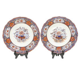
19th C. Staffordshire Indian Ironstone Soup Bowls, PairNorthgate Gallery, Inc.4.5(36)See Sold PriceMar 02, 2024
Duval - Pair: Map of Georgia & Map of Moscow, RussiaTrillium Antique Prints & Rare Books4.5(32)See Sold PriceFeb 24, 2024
Duval - Pair: Map of India & Map of MaldivesTrillium Antique Prints & Rare Books4.5(32)See Sold PriceFeb 24, 2024
Audubon, NYSE Best Watercolor Ed - Pair: Brown Pelican & Reddish EgretTrillium Antique Prints & Rare Books4.5(32)See Sold PriceFeb 24, 2024
Map: A 19thC engraved map titled Gloucestershire from the Best Authorities, after John Cary. Approx.Claydon Auctioneers Ltd4.3(125)See Sold PriceFeb 26, 2024
Map: A 19thC engraved and hand coloured map of Buckingham titled A New Map of BuckinghamshireClaydon Auctioneers Ltd4.3(125)See Sold PriceFeb 26, 2024
Map: A 19thC engraved map of West Riding, titled A Map of the North Part of the West Riding ofClaydon Auctioneers Ltd4.3(125)See Sold PriceFeb 26, 2024
JOHN RICHARD TROPICAL IMPRESSIONS PRINTS 27"DejaVu Estate Sales & Auctions, LLC4.6(1.3k)See Sold PriceFeb 26, 2024
Pair of Signed John Clem Clarke Lithographs, 'Chardin: "Girl with a Racquet and Shuttlecock"'PUBLIC SALE4.7(226)See Sold PriceMar 02, 2024
A Pair of John Cook Phoenix Studio Art Glass LampsGray's Auctioneers4.5(187)See Sold PriceMar 06, 2024
Blackie (Pub) 1882 Pair of Folio Maps. Italy - North & SouthAlbion Auctions4.6(341)See Sold PriceMar 01, 2024
Pair of Robert, John Kennedy Brothers Photo PrintsConnoisseur Auctions3.9(336)See Sold PriceMar 16, 2024
John Hagee Pair of Judaica Jerusalem Stone CandlesticksAntique Kingdom4.1(21)See Sold PriceMar 08, 2024
John Senex Map of Louisiana & Mississippi RiverWillow Auction House4.5(289)See Sold PriceMar 14, 2024