1952 ROBERT F. KENNEDY HANDWRITTEN LETTERJohn McInnis Auctioneers,LLC4.6(502)See Sold PriceFeb 25, 2024
CASED PRESENTATION HALF HULL MODEL OF THE BARQUE "HAWTHORNBANK" Last Quarter of the 19th CenturyEldred's4.7(409)See Sold PriceFeb 27, 2024
Lot Of 14 Jack Daniels And Country Club Glass Spirit BottlesRbfinearts4.4(571)See Sold PriceFeb 24, 2024
PR OF 17TH C. SPANISH BRASS CANDLESTICKSThomaston Place Auction Galleries4.4(386)See Sold PriceFeb 24, 2024
Lake Shore and Michigan Southern RR Special Excursions Timetable-July 7-13, 1892JM Hobby Supply and Railroad Artifact Auctions4.4(126)See Sold PriceFeb 24, 2024
Tiffany & Co. Sterling Silver Corkscrew Bottle OpenerSJ Auctioneers4.5(165)See Sold PriceMar 03, 2024
Rolls Royce Landau c1950s Gin/ Scotch TantalusPasadena Antique Auctions4.3(6)See Sold PriceMar 10, 2024
SoldNorth Pacific Coast Ports w/3 maps 1894Title: North Pacific Coast Ports (cover title) Author: Samuels, Frederick K., compiler Description: [8], 77, [1] + [15] ad pp. With 3 folding maps; illustrations from photographs. 21.3x14.5 cm. (8½x5See Sold Price
Sold7 ooks, Alaska, North Pacific CoastBook lot Alaska, Pacific Coast, includes : The Wilderness of the North Pacific Coast Islands. By Charles Sheldon. New York: Charles Scribner’s Sons. 1912.; The Wilderness of the Upper Yukon: A HunteSee Sold Price
Sold2 Spanish charts of the North Pacific Coast72map396 [BRITISH COLUMBIA]. Carta Esferica de las reconocimientos hechos en 1792 en la Costa N.O. de America para Examinar la Entrada de Juan Fuca, y la internacion de sus Canales navigables, LevantaSee Sold Price
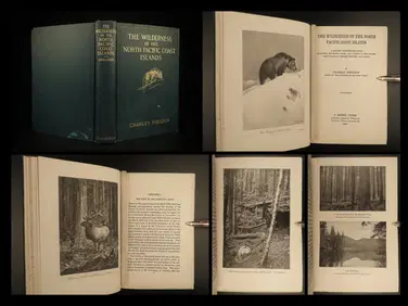
SoldThe Wilderness of the North Pacific Coast IslandsAuthor: Sheldon, Charles Description: xvi, 246 pp. Illus. with photo plates; 5 photogravures from drawings by Carl Rungius; 5 maps. 8¼x5¼, original gilt-lettered cloth, gilt cover vignette, top edgeSee Sold Price
SoldFive Maps by the Hydrographic Office U. S. Navy,Five Maps by the Hydrographic Office U. S. Navy, consisting of "Pertuis D'Antioche and Approaches to La Rochelle and Rochefort," 1922, H. - 29 3/4 in., W. - 42 in.; "France North Coast- Port of CherboSee Sold Price
SoldRand-McNally Denver to Pacific Coast Map 1911 ThisThis is an original colored Map of Denver to the Pacific Coast including: Colorado, Montana, Idaho, Washington, Oregon,California, Utah, Nevada, Arizona, Wyoming, New Mexico, and a small sliver ofTexaSee Sold Price
SoldAlaska and Missions on the North Pacific CoastAuthor: Jackson, Sheldon Description: 327 pp. Frontispiece, folding map and numerous full page and in text illustrations. 7¼x5, original green cloth lettered and decorated in gilt and black. First EdSee Sold Price
Los Angeles, California – Pacific Coast North America -Title/Content of Map: Los Angeles, California – Pacific Coast North America - British Admiralty Chart 899, published 1885 Date: 1885 Cartographer: Brittish Admiralty Material/Medium: thick paper SizSee Sold Price
Los Angeles, California – Pacific Coast North America -Title/Content of Map: Los Angeles, California – Pacific Coast North America - British Admiralty Chart 899, published 1885 Date: 1885 Cartographer: Brittish Admiralty Material/Medium: thick paper SizSee Sold Price
SoldDenver to Pacific Forest & Parks Map McNally 1912This is an original Denver to Pacific Coast map of National Forests, National Parks, National Monuments. The piece is by Rand, McNally & Co.'s New Commerical Map of United States circa 1912. The map iSee Sold Price
SoldOriginal Imray & Son Nautical Chart of North Pacific,Imray & Son map of North Pacific showing the coast of Asia, including China, Manchooria, Nipon, Tungusi, Koriaki and more. The map also features Alaska and islands, British America, and the west coastSee Sold Price
Venezuela coast. Aruba Bonaire Curacao. ADMIRALTY sea chart 1894 (1955) mapTITLE/CONTENT OF MAP: 'South America - North Coast - Tortuga to Cabo la Vela // Catia de la Mar' DATE PRINTED: Surveyed to 1942. Published 1894. New edition 1946. Corrections to 1955 IMAGE SIZE: ApproSee Sold Price
Venezuela coast. Aruba Bonaire Curacao. ADMIRALTY sea chart 1894 (1955) mapTITLE/CONTENT OF MAP: 'South America - North Coast - Tortuga to Cabo la Vela // Catia de la Mar' DATE PRINTED: Surveyed to 1942. Published 1894. New edition 1946. Corrections to 1955 IMAGE SIZE: ApproSee Sold Price
EARLY FRENCH MAP OF THE NORTH PACIFICEarly hand-colored map of the North Pacific, 15 1/4" x 11 3/4", printed in French circa 1779-1780 by "Dupuis". The map depicts the coast of Asia from southern China to the Kamchatka Peninsula, the JapSee Sold Price
Central America Caribbean Gulf of Mexico chart Ports lighthouses LARGE 1918 mapTITLE/CONTENT OF MAP: 'Central American and West Indian Ports; Inset The Pacific Coast from San Diego to Vancouver; San Francisco; Aleutian; The Pacific Coast from Seattle to Dutch Harbor; Bermudas; KSee Sold Price
Central America Caribbean Gulf of Mexico chart Ports lighthouses LARGE 1918 mapTITLE/CONTENT OF MAP: 'Central American and West Indian Ports; Inset The Pacific Coast from San Diego to Vancouver; San Francisco; Aleutian; The Pacific Coast from Seattle to Dutch Harbor; Bermudas; KSee Sold Price
SoldCommerce of Pacific Coast, 1882Heading: Author: Hittell, John S. Title: The Commerce and Industries of the Pacific Coast of North America; comprising the rise, progress, products, present condition, and prospects of the useful artSee Sold Price
SoldCentral America Caribbean Gulf of Mexico chart PortsTITLE/CONTENT OF MAP: 'Central American and West Indian Ports; Inset The Pacific Coast from San Diego to Vancouver; San Francisco; Aleutian; The Pacific Coast from Seattle to Dutch Harbor; Bermudas; KSee Sold Price
Philip & Son: Map of Central America Caribbean, 1914TITLE/CONTENT OF MAP: 'Central American and West Indian Ports; Inset The Pacific Coast from San Diego to Vancouver; San Francisco; Aleutian; The Pacific Coast from Seattle to Dutch Harbor; Bermudas; KSee Sold Price
Central America Caribbean Gulf of Mexico chart PortsTITLE/CONTENT OF MAP: 'Central American and West Indian Ports; Inset The Pacific Coast from San Diego to Vancouver; San Francisco; Aleutian; The Pacific Coast from Seattle to Dutch Harbor; Bermudas; KSee Sold Price
Central America Caribbean Gulf of Mexico chart PortsTITLE/CONTENT OF MAP: 'Central American and West Indian Ports; Inset The Pacific Coast from San Diego to Vancouver; San Francisco; Aleutian; The Pacific Coast from Seattle to Dutch Harbor; Bermudas; KSee Sold Price
Plan du Port dAcapulco, sur la Côte du Mexique'.TITLE/CONTENT OF MAP: 'Plan du Port dAcapulco, sur la Côte du Mexique dans la Mer du Sud [Plan of the Port of Acapulco on the Pacific coast of Mexico]' DATE PRINTED: 1754 IMAGE SIZE: Approx 20.0 x 16See Sold Price
Plan du Port dAcapulco, sur la Côte du Mexique'.TITLE/CONTENT OF MAP: 'Plan du Port dAcapulco, sur la Côte du Mexique dans la Mer du Sud [Plan of the Port of Acapulco on the Pacific coast of Mexico]' DATE PRINTED: 1754 IMAGE SIZE: Approx 20.0 x 16See Sold Price
Sold(19th c) NAUTICAL CHARTS and MAPS(12) James Imray London 1881 China and Japan, Australia and New Zealand, South Part of the North Sea, Coast of North American, Ports of India 1870, Laurie Coast of China, etc. Together with approx 1See Sold Price
Southern Pacific RR Four Gateways to the Pacific Coast Brochure-1917JM Hobby Supply and Railroad Artifact Auctions4.4(126)See Sold PriceFeb 24, 2024
Tammy Callens (WY,CA,France,b 1962) oil paintingBroward Auction Gallery4.8(277)See Sold PriceMar 31, 2024
Portfolio of 15 County Maps by Robert Morden (English 1650-1703)Nadeau's Auction Gallery4.7(401)See Sold PriceFeb 24, 2024
1912 HUNTING Alaska Vancouver Sheldon Wilderness of North Pacific Canada BearSchilb Antiquarian Rare Books4.8(421)See Sold PriceMar 31, 2024
1764 Bellin Map of Port Antonio, Jamaica -- Plan des Havres de Port Antonio et de Saint FrancoisJasper524.5(9.8k)See Sold PriceFeb 27, 2024
WEST AFRICA. British Cameroons & Togoland mandates. Gold Coast Nigeria 1947 mapJasper524.5(9.8k)See Sold PriceFeb 28, 2024
NORTH & WEST AFRICA. Gold Coast (Ghana) Slave Coast. Tribal names 1890 mapJasper524.5(9.8k)See Sold PriceFeb 28, 2024
North & West Africa. Dahomey. Gold Coast. Military Territory. THE TIMES 1922 mapJasper524.5(9.8k)See Sold PriceFeb 28, 2024
Dubreus Lherisson Voodoo FlagRapid Estate Liquidators and Auction Gallery4.5(1.1k)See Sold PriceFeb 24, 2024
Blackie (Pub) 1882 Folio Map. West USA - Pacific StatesAlbion Auctions4.6(336)See Sold PriceMar 01, 2024