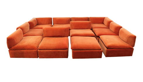
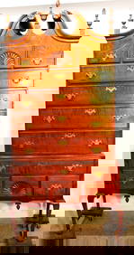
11pc. MCM Vintage Modular Sofa Set, removable backs, make up your own setting, desirable orangeSouth Jersey Auction by Babington Auction Inc4.6(122)See Sold PriceFeb 25, 2024
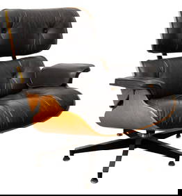
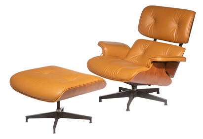
Charles & Ray Eames for Herman Miller Lounge ChairAuctions at Showplace4.5(726)See Sold PriceMar 03, 2024
Important Qianlong Chinese Export Hunt Scene BowlPremier Auction Galleries4.3(329)See Sold PriceMar 09, 2024
A FINE CHINESE CLOISONNE ENAMEL LONGEVITY TABLE SCREENBerkeley Auction Gallery4.4(16)See Sold PriceMar 03, 2024
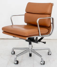
Eames for Herman Miller Executive Soft Pad ChairAuctions at Showplace4.5(726)See Sold PriceMar 03, 2024
Danish Mid-Century Modern Model CH 25 Lounge Chair in Oak and Leather by Hans J. Wegner for CarlBidhaus4.3(747)See Sold PriceFeb 26, 2024
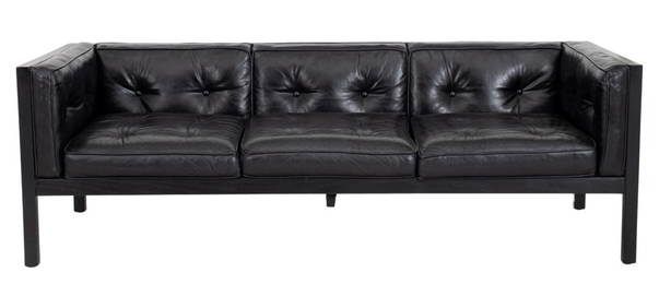
George Nelson Herman Miller Leather "Cube" SofaAuctions at Showplace4.5(726)See Sold PriceMar 03, 2024
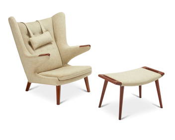
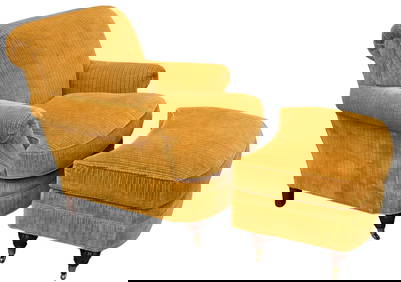
Hans Wegner (1914-2007), AP-19 Papa Bear chair and ottoman for A.P. Stolen, 1953-1969; DenmarkJohn Moran Auctioneers, Inc.4.7(453)See Sold PriceFeb 27, 2024
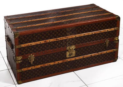
A FINE LARGE LOUIS VUITTON TRAVELING WARDROBE C. 1920sSoulis Auctions4.8(953)See Sold PriceFeb 24, 2024
Period 18Th C. Queen Anne Bonnet Top Tiger Maple HighboyRalph Fontaine Heritage Auctions Inc.4.7(235)See Sold PriceFeb 25, 2024
Rare Mid-Century Modern Egyptian Revival Ebonized "Thebes" Stool by Liberty & Company UnitedBidhaus4.3(747)See Sold PriceFeb 26, 2024
Lewis Mittman Upholstered Club Chair and OttomanNadeau's Auction Gallery4.7(401)See Sold PriceFeb 24, 2024
Single Bentwood Prague Model 811 Dining Chair by Josef Frank Josef Hoffmann for Stendig withBidhaus4.3(747)See Sold PriceFeb 24, 2024
SoldNorth & South America in 1776 MapAuthor: Zantac, Antonio. L'America Divisa ne suoi Principali Stati di Nuova Projezione. Published inc Venice in 1776. Overall with frame 16" high x 20-1/4" wide. On laid paper with center crease withSee Sold Price
SoldNorth & South America in 1776Heading: Author: Zatta, Antonio Title: L'America Divisa ne suoi Principali Stati di Nuova Projezione... Place Published: Venice Publisher: Date Published: 1776 Description:See Sold Price
SoldAntonia Zatta (Italian, 1757-1797),Antonia Zatta (Italian, 1757-1797), hand-colored engraved map of North and South America, dated 1776, presented in a striped French mat within a carved wooden frame and glazed, h. 15", w. 19".See Sold Price
Sold1 piece. Engraved Map with Outline Color. Romans,1 piece. Engraved Map with Outline Color. Romans, Bernard. A General Map of The Southern British Colonies in America... North and South Carolina, Georgia, East and West Florida,..." [London], 1776. 20See Sold Price
SoldCarte D’Amerique North & South America MapOn laid paper, by on your expertise, we can provide additional photos if necessary , back in not accessible Frame 31 x 27See Sold Price
Soldc. 1717 North & South America Map as Discovered byHistoric Maps Impresive c. 1717 Map of the Americas by Nicolas de Fer with Title “ISLE DE CALIFORNIE” Prominently Shown c. 1717, Map of the Americas titled “Map of North and Middle America, baseSee Sold Price
Soldc. 1717 North & South America Map as Discovered byHistoric Maps c. 1717 “ISLE DE CALIFORNIE” Map of the Americas c. 1717, Map of the Americas titled “Map of North and Middle America, based on the observations of the members of the Academy of ScSee Sold Price
Soldc. 1717 North & South America Map as Discovered byHistoric Maps c. 1717 Map of the Americas Title “ISLE DE CALIFORNIE” c. 1717, Map of the Americas titled “Map of North and Middle America, based on the observations of the members of the AcademySee Sold Price
SoldNorth and South America Map"Noviffima et Accuratifima Totius Americae Descriptio per Jacobum Meursium" Vingettes of mermaids and angels and possibly the god Neptune (upper) and workers (lower) as well as ships in the seas andSee Sold Price
SoldCirca 1747 North and South America Map. OriginalCirca 1747 North and South America Map. Original Color. Mapmaker Eman. Bowen. Map and Print Seller, Engraver to George II of England and Louis XV of France. He had a Prolific Output. Worked in LondonSee Sold Price
Sold1690's North and South America Map California as ITwo Beautiful 17th Century map of North America and South America. Each about 8 x 6", Dated 1690, two truly historic beautifully detailed very early maps. One is titled "L'AMERIQUE Septentrionale." inSee Sold Price
Sold1690's North and South America Map of CaliforniaSubtitle: Description:Two Beautiful 17th Century map of North America and South America. Each about 8 x 6", Dated 1690, two truly historic beautifully detailed very early maps. One is titled "L'AMERIQSee Sold Price
Sold1690's North and South America Map California asTwo Beautiful 17th Century map of North America and South America. Each about 8 x 6", Dated 1690, two truly historic beautifully detailed very early maps. One is titled "L'AMERIQUE Septentrionale." inSee Sold Price
SoldNorth & South America in 1776Heading: (Americas) Author: Zatta, Antonio Title: L'America Divisa ne suoi Principali Stati di Nuova Projezione... Place Published: Venice Publisher: Date Published: 1776 Description: <See Sold Price
SoldGeorge Virtue North and South America MapImage size: 10 1/2" x 8 1/4". Date: 1860. Slightly colored. With original paper label from Lyons Ltd. Antique Prints. Professionally framed and matted.See Sold Price
Sold1690's North and South America Map California asTwo Beautiful 17th Century map of North America and South America. Each about 8 x 6", Dated 1690, two truly historic beautifully detailed very early maps. One is titled "L'AMERIQUE Septentrionale." inSee Sold Price
SoldContemporary School, stitched paper collageContemporary School, stitched paper collage, 21st c., North and South America Map, multimedia collage, no signture observed, 29"h x 23.25"w (sight), 37"h x 31.5"w (frame)See Sold Price
Map North /South AmericaMap depicting America from early 17th c - - North and South America map on laid paper about 8 x 9 1/2 inchesSee Sold Price
SoldBartholomew, John 1889 Lot of 5 Continents MapsCommercial Continent Maps of Asia, Africa, Europe, North & South America. Lithograph Maps Published 1889, Cambridge for "Atlas of Commercial Geography" by John George Bartholomew. Paper Size: 12 x 10See Sold Price
Sold1901 PAN-AMERICAN EXPOSITION DECORATED OPAL MINIATURE1901 PAN-AMERICAN EXPOSITION DECORATED OPAL MINIATURE LAMP, opaque white with shaded pink ground and polychrome transfer decoration, ball-form font with North and South America maps with joined handsSee Sold Price
Sold1901 PAN-AMERICAN EXPOSITION DECORATED OPAL MINIATURE1901 PAN-AMERICAN EXPOSITION DECORATED OPAL MINIATURE LAMP, opaque white with shaded blue ground and polychrome transfer decoration, ball-form font with North and South America maps with joined handsSee Sold Price
Sold1901 PAN-AMERICAN EXPOSITION DECORATED OPAL MINIATURE1901 PAN-AMERICAN EXPOSITION DECORATED OPAL MINIATURE LAMP, opaque white with shaded pink ground and polychrome transfer decoration, ball-form font with North and South America maps with girls havingSee Sold Price
Sold1901 PAN-AMERICAN EXPOSITION DECORATED OPAL MINIATURE1901 PAN-AMERICAN EXPOSITION DECORATED OPAL MINIATURE LAMP, opaque white with shaded pink ground and polychrome transfer decoration, ball-form font with North and South America maps with joined handsSee Sold Price
Sold1901 PAN-AMERICAN EXPOSITION DECORATED OPAL MINIATURE1901 PAN-AMERICAN EXPOSITION DECORATED OPAL MINIATURE LAMP, opaque white with shaded blue ground and polychrome transfer decoration, ball-form font with North and South America maps with girls havingSee Sold Price
Arrowsmith & Lewis - Map of North AmericaTrillium Antique Prints & Rare Books4.5(30)See Sold PriceFeb 24, 2024
Arrowsmith & Lewis - Map of the World on Mercator's ProjectionTrillium Antique Prints & Rare Books4.5(30)See Sold PriceFeb 24, 2024
Arrowsmith & Lewis - Map of LouisianaTrillium Antique Prints & Rare Books4.5(30)See Sold PriceFeb 24, 2024
Arrowsmith & Lewis - Map of the United StatesTrillium Antique Prints & Rare Books4.5(30)See Sold PriceFeb 24, 2024
Carey, pub. 1796 - Map of the Tennassee State formerly part of North Carolina (Tennessee)Trillium Antique Prints & Rare Books4.5(30)See Sold PriceFeb 24, 2024
Map: An 18thC engraved and hand coloured map of North America and South America, titled DeClaydon Auctioneers Ltd4.3(125)See Sold PriceFeb 26, 2024
1822 MAP of NORTH & SOUTH AMERICA GEOGRAPHICAL STATISTICAL HISTORICAL antiqueJasper524.5(9.8k)See Sold PriceFeb 27, 2024
Mexico, Central America and West Indies Physical PoliticalJasper524.5(9.8k)See Sold PriceFeb 27, 2024