SoldNorth America According to the Latest ObservationsHeading: (Map - North America) Author: [Senex, J.] Title: North America According to the Latest Observations Place Published: Publisher: Date Published: c.1730 Description:See Sold Price
SoldSENEX, John (fl.1700-1740).* SENEX, John (fl.1700-1740). North America According to the Latest Observations. N.p.: n.p., [ca 1719]. Hand-colored engraved map of North America, image 153 x 175 mm (158 x 215 mm sheet). Showing CaSee Sold Price
Sold[NORTH & SOUTH American A, CUBMAPS] g[NORTH & SOUTH AMERICA, CUBA MAPS] A group of Seven Maps of the Americas comprising; "North American According to the Latest Observations", c.1730, by Senex, 6 in. x 7 in., showing California as an isSee Sold Price
SoldBlunt - The Coast of the United StatesEdmund March Blunt (1770-1862), The Coast of the United States of North America, from New York to St. Augustine, drawn and regulated according to the latest Surveys and Astronomical Observations by ESee Sold Price
SoldJohn Lodge North America Map, 1778North America, John Lodge, London 1778- ''A General Map of North America: from the Latest Observation''- Imprint recognizes that this second print uses Thomas Jeffery's 1776 plate with revisions. An eSee Sold Price
Tanner's large map of North America 1825Title: A Map of North America, Constructed According to the Latest Information Author: Tanner, Henry Schenck Description: Copper-engraved map, hand-colored. Originally issued on 4 sheets, this copy inSee Sold Price
SoldA NEW MAP OF NORTH AMERICA by Herman MOLLHistoric MapsCalifornia as an Island! "A NEW MAP OF NORTH AMERICA ACCORDING TO THE NEWEST OBSERVATIONS," By Herman Moll, Geographer, Choice Very Fine. Hand-colored in outline, this detailed maSee Sold Price
SoldMoll map with California an Island. 1745Heading: Author: Moll, Herman Title: A New Map of North America According to the Newest Observations Place Published: [London] Publisher: Date Published: [1745] Description:See Sold Price
SoldGeorge Willdey's Engraved Map of North AmericaMap of North America Corrected from the Latest Discoveries and Observations. George Willdey (fl.1707-1737). Engraved map with original color in outline mounted on scrolls. London, c. 1717. 38 x 26 incSee Sold Price
SoldLEA, Philip. A New Mapp of America Devided AccordiLEA, Philip. A New Mapp of America Devided According to the Best and latest Observations and Discoveries wherein are discribed by thear Proper Names the seaverall Countries that Belonge to ye EnglisSee Sold Price
Sold"Cod Fish" Map of North America by Moll 1719Heading: (North America) Author: Moll, Herman Title: [North America, i.e.] To the Right Honourable John Lord Sommers...this Map of North America According to ye Newest and Most Exact Observations is MSee Sold Price
SoldCa 1780 map Northern North AmericaCa. 1780 A Chorographical map of the Northern Department of North America, Drawn from the latest and most accurate observations at Amsterdam by Covens, Mortier, & Covens Junior. Engraved by H KlockhofSee Sold Price
SoldHerman Moll (Dutch/English, 1654-1732)Herman Moll (Dutch/English, 1654-1732), "...Map of North America, According to ye Newest and most Exact Observations...", c. 1719, London, engraved copperplate map, on two joined sheets, in hand-colorSee Sold Price
SoldHerman Moll (1654-1732)Herman Moll (1654-1732), "To the Right Honourable John Lord Sommers...this Map of North America according to ye newest and most exact observations...", London, "Printed for I. Bowles... T. Bowles... PSee Sold Price
Sold"Cod Fish" Map of North America by Moll 1719Title: [North America, i.e.] To the Right Honourable John Lord Sommers...this Map of North America According to ye Newest and Most Exact Observations is Most Humbly Dedicated by Herman Moll GeographerSee Sold Price
Sold"Cod Fish" Map of North America by Moll 1719Title: [North America, i.e.] To the Right Honourable John Lord Sommers...this Map of North America According to ye Newest and Most Exact Observations is Most Humbly Dedicated by Herman Moll GeographerSee Sold Price
Gavit: Antique Map of Northern North America, 1840Map: A Chorographical Map of the Northern Department of North America Drawn from the Latest and most accurate Observations Maker: Gavit, John E. Size: 12 1/4 x 10 1/2 inches Date: 1840 Please note thaSee Sold Price
SoldSenex Map of North AmericaA New Map of America from the latest observations...John Senex (1678-1740). Hand-colored engraving. London, c. 1719. 19 x 22 inches visible, 21 1/2 x 25 inches framed. Unlike most maps of the period,See Sold Price
SoldEngraved Hand-Colored Map of North AmericaEngraved hand colored map, "A Map of North America with the European Settlements and Whatever Else Is Remarkable in Ye West Indies from the Latest and Best Observations," by Richard Seale, London; CalSee Sold Price
SoldSeale map of North America California an islandHeading: Author: Seale, Richard William Title: A Map of North America with the European Settlements & whatever else is remarkable in ye West Indies, from the latest and best Observations Place PublisSee Sold Price
SoldSEALE, R.W. "A Map of North America with theEuropean Settlements & whatever else is remarkable in ye West Indies, from the latest and best observations" engraving, C. 1745. From a Scarsdale, NY collector. Particularly notable for displaying CalSee Sold Price
SoldEngraved Hand-Colored Map of North AmericaEngraved hand colored map, "A Map of North America with the European Settlements and Whatever Else Is Remarkable in Ye West Indies from the Latest and Best Observations," by Richard Seale, London, CalSee Sold Price
SoldNorth America. Robert Seale (fl. circa 1745) A MapNorth America. Robert Seale (fl. circa 1745) A Map of North America with the European Settlements & Whatever else is Remarkable in ye West Indies from the latest and best Observations. London, c. 1745See Sold Price
SoldR.W. Seale, Map of North America, 1745"A Map of North America with the European Settlements & Whatever Else Is Remarkable in ye West Indies, from the Latest and Best Observations" drawn and engraved by Richard William Seale, London, 1745.See Sold Price
LARGE EARLY 18TH C. DUTCH CHART OF UPPER NORTH AMERICA, PIERRE MORTIER (1661-1711), FRAMEDThomaston Place Auction Galleries4.4(389)See Sold PriceFeb 24, 2024
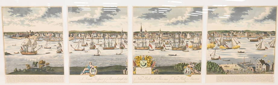
A South Prospect of Ye Flourishing City of New York in the Province of New York, North AmericaNadeau's Auction Gallery4.7(405)See Sold PriceFeb 24, 2024
Audubon's Animals - The Quadrupeds of North America 1954 Folio Size BookNorth American Artifact Auctions4.6(184)See Sold PriceApr 20, 2024
Arrowsmith & Lewis - Map of North AmericaTrillium Antique Prints & Rare Books4.5(30)See Sold PriceFeb 24, 2024
Map: An 18thC engraved and hand coloured map of North America and South America, titled DeClaydon Auctioneers Ltd4.3(125)See Sold PriceFeb 26, 2024
1862 North America Anthony Trollope West Indies AND Spanish Main CANADA NIAGARAJasper524.5(9.8k)See Sold PriceFeb 27, 2024
New and Correct Map of North America With the West India Islands,Jasper524.5(9.8k)See Sold PriceFeb 27, 2024
Map of United States of North America, 1785Antiques Online Auctions4.6(410)See Sold PriceMar 14, 2024


![[NORTH & SOUTH American A, CUBMAPS] g (1 of 0)](https://p1.liveauctioneers.com/dist/images/placeholder.jpg?height=282&quality=70)