2 Illuminated Books of Hours LeavesSchmidt's Antiques Inc. Since 19114.8(431)See Sold PriceMar 02, 2024
Illuminated Manuscript Leaf of The CrucifixionSchmidt's Antiques Inc. Since 19114.8(431)See Sold PriceMar 02, 2024
RARE 1930s AUTOGRAPH BOOK FEATURING RUTH & GEHRIGJohn McInnis Auctioneers,LLC4.6(502)See Sold PriceFeb 25, 2024
Timetable, Paper and Ephemera Lot-Eastern USA RailroadsJM Hobby Supply and Railroad Artifact Auctions4.4(126)See Sold PriceFeb 24, 2024
SCARCE 1971 Kim Il Sung Signed Book "ON THE WORK OF THE WOMAN'S UNION"Rbfinearts4.4(571)See Sold PriceFeb 24, 2024
1885 CIVIL WAR 1ed Famous Memoirs US Grant Sheridan Sherman 6v RARE LOT MapsSchilb Antiquarian Rare Books4.8(421)See Sold PriceMar 10, 2024
"WINTER AND SUMMER IN MAINE" 1904 PHOTO ALBUMJohn McInnis Auctioneers,LLC4.6(502)See Sold PriceFeb 25, 2024
1821 THE (3) VOYAGES of CAPT JAMES COOK VOL. I-VIIJohn McInnis Auctioneers,LLC4.6(502)See Sold PriceFeb 24, 2024
[BASEBALL]. [SHEET MUSIC]. KALBFLEISCH, J. H. The Live Oak ...Potter & Potter Auctions4.6(539)See Sold PriceMar 07, 2024
Illuminated Manuscript Leaf of The VisitationSchmidt's Antiques Inc. Since 19114.8(431)See Sold PriceMar 02, 2024
Illuminated Manuscript Leaf of GethsemaneSchmidt's Antiques Inc. Since 19114.8(431)See Sold PriceMar 02, 2024
c1700s RARE Arabic Handwritten Manuscript Middle East Persia Journal ARABIASchilb Antiquarian Rare Books4.8(421)See Sold PriceMar 10, 2024
SoldMS. map of sea routes to Nagasaki c.1841Heading: (Asian) Author: Inoue Gen (Inouehara?) Title: “Nagasaki kairiku no zu” - [Map of sea travel from Nagasaki] Place Published: [Nagasaki, Japan?] Publisher: Date Published: Tempo12 [184See Sold Price
SoldCanada.- Philip & Son (George, publisher) Picture MapNO RESERVE Canada.- Philip & Son (George, publisher) Picture Map of Newfoundland, map of the island with inset map showing sea routes to Newfoundland from America and mainland Canada, lithograph printSee Sold Price
East Asia, East Indies & Australasia sea & shipping routes 1920 old mapTITLE/CONTENT OF MAP: 'Map showing the Sea Routes' DATE PRINTED: 1920 IMAGE SIZE: Approx 29.0 x 26.0cm, 11.5 x 10.25 inches (Large); Please note that this is a folding map. TYPE: Antique colour map COSee Sold Price
East Asia, East Indies & Australasia sea & shipping routes 1920 old mapTITLE/CONTENT OF MAP: 'Map showing the Sea Routes' DATE PRINTED: 1920 IMAGE SIZE: Approx 29.0 x 26.0cm, 11.5 x 10.25 inches (Large); Please note that this is a folding map. TYPE: Antique colour map COSee Sold Price
MS. map of Northern Pacific route 1884Heading: (Washington Territory - Northern Pacific Railroad) Author: Anderson, A., Engineer in Chief Title: Map Showing Definite Location of Northern Pacific Railroad from 25th to 50th Mile EastwardlySee Sold Price
SoldCAMY, Edward (1904-1958). Alaska Line / A Good-NaturedCAMY, Edward (1904-1958). Alaska Line / A Good-Natured Map of Alaska. Seattle: Farwest Lithograph & Printing, 1934. Pictorial map labeled with railways, sea routes, and highways, and filled with illusSee Sold Price
MS. map of Carmel by the Sea 1907Title: Map of Addition No. 3 Carmel by the Sea, Monterey County, Cal. Surveyed Dec. 1906 and April 1907 by H.B. Fisher Surveyor & C.E. San Jose Cal. Scale 100 ft. to 1 inch Author: Fisher, H.B. DescriSee Sold Price
MS. map of Carmel by the Sea 1907Title: Map of Addition No. 4 Carmel by the Sea, Monterey County, California. Surveyed September 1907 by H.B. Fisher Surveyor & C.E. San Jose Cal. Scale 100 ft. to 1 inch Author: Fisher, H.B. DescriptiSee Sold Price
Eastern Europe sea chart Ports Lighthouses mail route Black Sea Baltic 1918 mapTITLE/CONTENT OF MAP: 'Eastern European Ports and Waterways' DATE PRINTED: 1918 IMAGE SIZE: Approx 49.0 x 34.0cm, 19.25 x 13.5 inches (Large) TYPE: Antique colour maritime map chart; Scale 1:20,000,00See Sold Price
Eastern Europe sea chart Ports Lighthouses mail route Black Sea Baltic 1916 mapTITLE/CONTENT OF MAP: 'Eastern European Ports and Waterways' DATE PRINTED: 1916 IMAGE SIZE: Approx 49.0 x 34.0cm, 19.25 x 13.5 inches (Large) TYPE: Antique colour maritime map chart; Scale 1:20,000,00See Sold Price
Eastern Europe sea chart Ports Lighthouses mail route Black Sea Baltic 1918 mapTITLE/CONTENT OF MAP: 'Turkey in Europe and Hungary' DATE PRINTED: 1805 IMAGE SIZE: Approx 19.5 x 23.0cm, 7.5 x 9 inches (Medium); Please note that this is a folding map. TYPE: Antique engraved copperSee Sold Price
Eastern Europe sea chart Ports Lighthouses mail route Black Sea Baltic 1916 mapTITLE/CONTENT OF MAP: 'Eastern European Ports and Waterways' DATE PRINTED: 1916 IMAGE SIZE: Approx 49.0 x 34.0cm, 19.25 x 13.5 inches (Large) TYPE: Antique colour maritime map chart; Scale 1:20,000,00See Sold Price
SoldIndia.- Wyld (James) Map of the Countries betweenIndia.- Wyld (James) Map of the Countries between England and India Designed to shew the Over-Land and Sea Routes to the East..., map of Europe and Asia between Britain and India, with the MediterraneSee Sold Price
SoldA. Kircher, Map of Asia, 1667A. Kircher, "Tabula Geodoborica Itinerum a Varijs in Cataium Susceptorum Rationem Exhibens", 1667, map of Asia depicts the land and sea routes from the Middle East to China and northern Asia. Roads, tSee Sold Price
Sold1936 Japanese Showa Period Map of ChinaItem: 1936 Japanese Showa Period Map of China Description: An interesting map of China, showing topographical features, the Great Wall, cities, railroads and sea routes. Insets are the regions of ChinSee Sold Price
SoldCivil War Era Map of Charleston, SC and EnvironsE & G. W. Blunt's Map of Charleston and Vicinity (New York: E & G. W. Blunt, 1862), a handy map for military purposes showing both land and sea routes in the region. Unframed in a 1950s mailing/storagSee Sold Price
SoldStoopendaal/Keur: Map of Beloved Land Canaan, 1609A splendid map of "the beloved land of Canaan," oriented with west at the top of the page and featuring a multitude of place names as well as St. Paul's sea route from Jerusalem to Rome. The Holy LandSee Sold Price
SoldThe Mediterranean, Seaports and Sea Routes by BaedekerHandbook for travelers with 38 fold-out maps and 49 plans. 1st edition Guide Book published 1911 Leipzig: Karl Baedeker, publisher. London: T. Fisher Unwin, 1 Adelphi Terrace, W.C., New York: CharlesSee Sold Price
1950s Folding Map of Sanyo Railway Route in Japan1950s Folding Map of Sanyo Railway Route in Japan -- The Sanyo Railway Co., L'D. of Japan Inland Sea Route Kobe to Shimonoseki. Sanyo Co., Japan. 1950s c., Kobe. 37.5 X 14.8 in.; 7.4 X 3.75 folded. InSee Sold Price
1950s Folding Map of Sanyo Railway Route in Japan --1950s Folding Map of Sanyo Railway Route in Japan -- The Sanyo Railway Co., L'D. of Japan Inland Sea Route Kobe to Shimonoseki 1950s c., Kobe Sanyo Co., Japan 37.5 X 14.8 in.; 7.4 X 3.75 in. folded InSee Sold Price
Vintage Folding Map of Sanyo Railway in Japan, 1950Title/Content of Map: 1950s Folding Map of Sanyo Railway Route in Japan -- The Sanyo Railway Co., L'D. of Japan Inland Sea Route Kobe to Shimonoseki Date Printed: 1950s c., Kobe Cartographer: Sanyo CoSee Sold Price
1950s Folding Map of Sanyo Railway Route in Japan --Title/Content of Map: 1950s Folding Map of Sanyo Railway Route in Japan -- The Sanyo Railway Co., L'D. of Japan Inland Sea Route Kobe to Shimonoseki Date: 1950s c., Kobe Cartographer: Sanyo Co., JapanSee Sold Price
Vintage Folding Map of Sanyo Railway Route, Japan, 1950Map: 1950s Folding Map of Sanyo Railway Route in Japan -- The Sanyo Railway Co., L'D. of Japan Inland Sea Route Kobe to Shimonoseki Cartographer: Sanyo Co., Japan Year / Place: 1950s c., Kobe DimensioSee Sold Price
1950s Folding Map of Sanyo Railway Route in Japan --Title/Content of Map: 1950s Folding Map of Sanyo Railway Route in Japan -- The Sanyo Railway Co., L'D. of Japan Inland Sea Route Kobe to Shimonoseki Date: 1950s c., Kobe Cartographer: Sanyo Co., JapanSee Sold Price
Central Railroad of New Jersey 13th Annual Report-January 1, 1860JM Hobby Supply and Railroad Artifact Auctions4.4(126)See Sold PriceFeb 24, 2024
Chicago Danville and Vincennes RR Gold Bond Prospectus Book-1872JM Hobby Supply and Railroad Artifact Auctions4.4(126)See Sold PriceFeb 24, 2024
Chicago Rock Island and Pacific RR 11th Annual Report-April 1, 1891JM Hobby Supply and Railroad Artifact Auctions4.4(126)See Sold PriceFeb 24, 2024
Michigan Southern and Northern Indiana RR 14th Annual Report-February 28, 1869JM Hobby Supply and Railroad Artifact Auctions4.4(126)See Sold PriceFeb 24, 2024
Ohio and Pennsylvania RR 1st Annual Report-1849JM Hobby Supply and Railroad Artifact Auctions4.4(126)See Sold PriceFeb 24, 2024
Ohio and Pennsylvania RR 2nd Annual Report-March 4, 1850JM Hobby Supply and Railroad Artifact Auctions4.4(126)See Sold PriceFeb 24, 2024
Chicago Rock Island and Pacific RR Book Sunshine and Moonlight-1889JM Hobby Supply and Railroad Artifact Auctions4.4(126)See Sold PriceFeb 24, 2024
Delaware and Hudson RR International Holidays Book-1912JM Hobby Supply and Railroad Artifact Auctions4.4(126)See Sold PriceFeb 24, 2024
Eastern RR Summer Book of Tours-1884JM Hobby Supply and Railroad Artifact Auctions4.4(126)See Sold PriceFeb 24, 2024
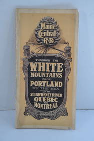
Maine Central RR Through the White Mtns-Portland to the St Lawrence River Book-1901JM Hobby Supply and Railroad Artifact Auctions4.4(126)See Sold PriceFeb 24, 2024
Santa Fe RR Summer in Southern California Book-1895JM Hobby Supply and Railroad Artifact Auctions4.4(126)See Sold PriceFeb 24, 2024
Wabash RR A Vacation For Everybody Book-1920JM Hobby Supply and Railroad Artifact Auctions4.4(126)See Sold PriceFeb 24, 2024
Lehigh Valley RR 1891 PassJM Hobby Supply and Railroad Artifact Auctions4.4(126)See Sold PriceFeb 24, 2024
Chicago Burlington and Quincy RR Spring 1890 Public TimetableJM Hobby Supply and Railroad Artifact Auctions4.4(126)See Sold PriceFeb 24, 2024
Illinois Central RR July 24, 1906 Western Lines Public TimetableJM Hobby Supply and Railroad Artifact Auctions4.4(126)See Sold PriceFeb 24, 2024
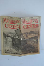
Michigan Central RR May 18, 1884 Public TimetableJM Hobby Supply and Railroad Artifact Auctions4.4(126)See Sold PriceFeb 24, 2024
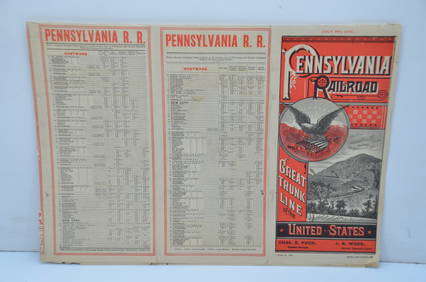
Pennsylvania Railroad July 8, 1885 Public TimetableJM Hobby Supply and Railroad Artifact Auctions4.4(126)See Sold PriceFeb 24, 2024
Eight Gulf, Mobile & Ohio Railroad Playing Card Decks - Alton Route Map and LogoRail & Road Auctions4.6(165)See Sold PriceMar 08, 2024
An "Official Disneyland Road Map" Richfield Brochure.Van Eaton Galleries4.6(99)See Sold PriceMar 02, 2024
Matson SS Mariposa South Seas Lithograph Travel Cruise PosterClark's Auction Company4.6(433)See Sold PriceMar 03, 2024


![[BASEBALL]. [SHEET MUSIC]. KALBFLEISCH, J. H. The Live Oak ... (1 of 5)](https://p1.liveauctioneers.com/928/318880/171361400_1_x.jpg?height=282&quality=70&version=1707501302)