SoldMount & Page. Charts of Lowestoft & OrfordnessMount (J.) and T. Page. Publishers. A New and Correct Chart of the Sea Coast from Lowestoft to Orford; A New and Correct Chart of the Sea Coast from Orfordness Lights to Prittlewell,2 coastalSee Sold Price
SoldMount (J.) and T. Page. Publishers. A New and CorMount (J.) and T. Page. Publishers. A New and Correct Chart of the Sea Coast from Lowestoft to Orford; A New and Correct Chart of the Sea Coast from Orfordness Lights to Prittlewell,2 coastalSee Sold Price
Mount & Page: Chart of The haven and city of GalipoliTITLE/CONTENT OF MAP: 'The haven and city of Galipoli' DATE PRINTED: 1747 IMAGE SIZE: Approx 13.0 x 17.5cm, 5 x 7 inches (Small) TYPE: Antique 18th century copperplate map CONDITION: Good; suitable foSee Sold Price
SoldMount & Page Chart of the English ChannelMount (William) & Thomas Page A New and Correct Chart of the Channel between England & France, large engraved chart of the English Channel, inset maps of Plymouth Sound and the Isle of Wight,See Sold Price
Mount & Page: Chart of island & roads before Fogia NovaTITLE/CONTENT OF MAP: 'A description of the island and roads before Fogia Nova' The following places are shown or referred to on the map: Yenifoca Red Rock St George DATE PRINTED: 1747 IMAGE SIZE: AppSee Sold Price
Mount & Page: Antique Chart Map of Chios, Greece, 1747Title/Content of Map: 'Xio als Sio' Chios town, Greece. Sea chart and view Date Printed: 1747 Image Size: Approx 11.5 x 21.0cm, 4.5 x 8.25 inches (Small) Type: Antique 18th century copperplate map ConSee Sold Price
Mount & Page: Sea Chart of The haven of Brundisi, 1747TITLE/CONTENT OF MAP: 'The haven of Brundisi' DATE PRINTED: 1747 IMAGE SIZE: Approx 23.0 x 18.0cm, 9 x 7 inches (Medium) TYPE: Antique 18th century copperplate map CONDITION: Good; suitable for framinSee Sold Price
Mount & Page: Sea Chart of The bay of Tunis, 1747TITLE/CONTENT OF MAP: 'The bay of Tunis' The following places are shown or referred to on the map: Carthage R Mezarenda Porto Farino C Guardia Gamorola Zambra Ane Zambra Tunis Byes House Castle GalletSee Sold Price
Mount & Page: Sea Chart of The road of Ancona. Italy.TITLE/CONTENT OF MAP: 'The road of Ancona' DATE PRINTED: 1747 IMAGE SIZE: Approx 10.5 x 23.5cm, 4.25 x 9.25 inches (Medium) TYPE: Antique 18th century copperplate map CONDITION: Good; suitable for fraSee Sold Price
Map of the Syrtic & Libyan Seas,Title: Map of the Syrtic & Libyan Seas, Publication Date: 1790 ca. Cartographer: LE KEUX, J. sc. Size: 8.6X18.5 "the distance taken from Mount & Page's grand chart of the Mediterranean." Later colorinSee Sold Price
Mount & Page Map of the Atlantic, 1723MOUNT & PAGE. A General Chart of the Western Ocean. Engraved map. London: W. Mount & T. Page, c. 1723-1773. 18 7/8” x 23 1/2” sheet. Handsome and scarce sea chart of the North Atlantic covering thSee Sold Price
Map of the Syrtic & Libyan Seas,Title: Map of the Syrtic & Libyan Seas, Cartographer: LE KEUX, J. sc. Size: 8.6Height - 18.5Width "the distance taken from Mount & Page's grand chart of the Mediterranean." Later coloring. Reserve: $7See Sold Price
Map of the Syrtic & Libyan Seas,Publication Date: c1790 Title: Map of the Syrtic & Libyan Seas, Cartographer: LE KEUX, J. sc. Publisher: Height: 8.6 Width: 18.5 "the distance taken from Mount & Page's grand chart of the MediterraneaSee Sold Price
SoldMount & Page A Chart of ye Coast of BarbaryMount (J.) and T. Page. Publishers. A Chart of ye Coast of Barbary from Cape Geer to Cape Bajadore,with A Chart of ye Coast of Barbary from C. Bajadore to the Golfe of St. Anne, two charts onSee Sold Price
Mount & Page: Antique Sea Chart Map of Tripoli, 1747Title/Content of Map: 'Thus appeareth Tripoli' Lebanon. The following places are shown or referred to on the map: Mont Cru Mont Libano Porto Pasaichi Date Printed: 1747 Image Size: Approx 14.0 x 24.5cSee Sold Price
Mount & Page: Antique Sea Chart Map Haven of Zea, 1747Title/Content of Map: 'The haven of Zea' Kea Gia Tzia harbour Greece. Date Printed: 1747 Image Size: Approx 15.0 x 16.0cm, 6 x 6.25 inches (Medium) Type: Antique 18th century copperplate map ConditionSee Sold Price
Mount & Page: Antique Sea Chart Map of Livorno, 1747Title/Content of Map: 'Livorno als Ligorne' Italy, sea chart & city plan. The following places are shown or referred to on the map: Livorno Powder Watch Tower Boca Lazeretta Arno River estuary LivornoSee Sold Price
Mount & Page: Antique Sea Chart of Gulph of Smyrna 1747Title/Content of Map: 'The Gulph of Smyrna' Gulf of Izmir, Turkey. The following places are shown or referred to on the map: Cape Babernole Fogea Nova (Phocaea) Izmir Date Printed: 1747 Image Size: ApSee Sold Price
Mount & Page: Antique Sea Chart Map of Messina, 1747Title/Content of Map: 'The haven of Messina' Sicily, Italy. sea chart town plan Date Printed: 1747 Image Size: Approx 11.5 x 23.5cm, 4.5 x 9.25 inches (Medium) Type: Antique 18th century copperplate mSee Sold Price
Mount & Page: Antique Sea Chart Map Gulf of Engia, 1747Title/Content of Map: 'Here followeth the draught of the Gulf of Engia, or Athenen' The following places are shown or referred to on the map: Athens Porto Lion Viertoren St. Brusina (Salamina) GaudebSee Sold Price
Mount & Page: Antique Sea Chart Map of Tripoli, 1747Title/Content of Map: 'Thus appeareth Tripoli' Lebanon. The following places are shown or referred to on the map: Mont Cru Mont Libano Porto Pasaichi Date Printed: 1747 Image Size: Approx 14.0 x 24.5cSee Sold Price
SoldPortugal & Spain.- (W.J.) Mount & T. Page A Chart ofPortugal & Spain.- Mount (W.J.) & T. Page A Chart of the Sea Coasts of Algrave and Andalusia Between Cape St. Vincent and the Strait of Gibralter and C Spartel, English sea chart of the southern coastSee Sold Price
Mount & Page: Antique Sea Chart Bay of Marcellia, 1747TITLE/CONTENT OF MAP: 'Bay of Marcellia' The following places are shown or referred to on the map: Marcellia (Marseilles) Castle Dito (Chateau d'If) Lila (Les Iles) Caga Straca C. De Cruseta DATE PRINSee Sold Price
Mount & Page: Antique Sea Chart of The haven of MessinaTITLE/CONTENT OF MAP: 'The haven of Messina' DATE PRINTED: 1747 IMAGE SIZE: Approx 11.5 x 23.5cm, 4.5 x 9.25 inches (Medium) TYPE: Antique 18th century copperplate map CONDITION: Good; suitable for frSee Sold Price
Chicago Burlington and Quincy RR 8th Annual Report-June 24, 1864JM Hobby Supply and Railroad Artifact Auctions4.4(127)See Sold PriceFeb 24, 2024
Northern RR of New Hampshire Original Bylaws-1847JM Hobby Supply and Railroad Artifact Auctions4.4(127)See Sold PriceFeb 24, 2024
St Louis Alton and Terre Haute RR 1st Annual Report-January 1, 1864JM Hobby Supply and Railroad Artifact Auctions4.4(127)See Sold PriceFeb 24, 2024
Alco Locomotive Company Catalogue 10036-International Exposition Argentina 1910JM Hobby Supply and Railroad Artifact Auctions4.4(127)See Sold PriceFeb 24, 2024
17TH C. ENGLISH CHART OF THE THAMES BY CAPT. GREENVILLE COLLINS, 1693-4, FRAMEDThomaston Place Auction Galleries4.4(393)See Sold PriceFeb 24, 2024
BOTH TITLE PAGES OF COLLINS" COASTAL SURVEY, 1776, IN MATCHING FRAMESThomaston Place Auction Galleries4.4(393)See Sold PriceFeb 24, 2024
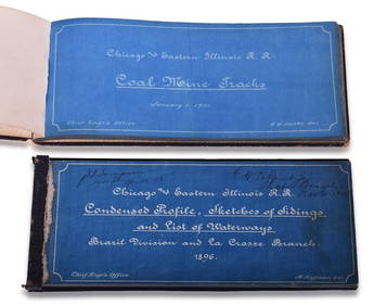
Chicago & Eastern Illinois Railroad 1901 Coal Mine Track and 1896 Brazil Division Track Chart BooksRail & Road Auctions4.6(165)See Sold PriceMar 08, 2024
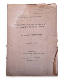
1908 Report on Proposed New York / New Jersey New Railway SystemRail & Road Auctions4.6(165)See Sold PriceMar 08, 2024
[NEW YORK STATE]. Scrapbook of photographs of Lake George a...Potter & Potter Auctions4.6(545)See Sold PriceMar 07, 2024
Carte d'Afrique. Africa Soudan Zanzibar. LAPIE 1831 old antique map plan chartJasper524.5(9.9k)See Sold PriceFeb 28, 2024
NORTH AFRICA. 'Biledulgerid', a former North African country. MALLET 1683 mapJasper524.5(9.9k)See Sold PriceFeb 28, 2024
Two Books About George WashingtonRapid Estate Liquidators and Auction Gallery4.5(1.1k)See Sold PriceMar 01, 2024
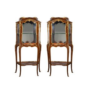
A FINE PAIR OF FRANCOIS LINKE GILT BRONZE MOUNTED CABINETSLos Angeles Antiques 4.3(12)See Sold PriceMar 10, 2024


![[NEW YORK STATE]. Scrapbook of photographs of Lake George a... (1 of 5)](https://p1.liveauctioneers.com/928/318880/171361558_1_x.jpg?height=282&quality=70&version=1707501302)