SoldMitchell's New General Atlas. 1863. 84 maps/insets[Atlas]. MITCHELL’S NEW GENERAL ATLAS, Containing Maps ot the the Various Countries of the World, Plans of Cities, Etc… Phila: S. Augustus Mitchell, 1863. 4to. Orig quarter leather and cloth. WornSee Sold Price
SoldMITCHELL’S NEW GENERAL ATLAS. 1863. 84 maps/insets[Atlas]. MITCHELL’S NEW GENERAL ATLAS, Containing Maps of the Various Coutnries of the World, Plans of Cities, Etc… Phila: S. Augustus Mitchell, 1863. Folio. 84 maps & insets (As numbered. MitchelSee Sold Price
SoldMitchell's New General Atlas,Containing Maps of the Various Countries of the World, etc. Philadelphia: S. Augustus Mitchell, 1863, 84 hand-colored maps and city plans on 49 sheets (complete), some being insets and others are doubSee Sold Price
Sold1 vol. Mitchell's New General Atlas. Philadelphia1 vol. Mitchell's New General Atlas. Philadelphia: S. Augustus Mitchell, Jr., 1863. Folio, orig. morocco & cloth; spine defective. Bdg. broken, sheets loose or coming loose. Complete with 84 hand-coloSee Sold Price
SoldMitchell's New General Atlas 1863Heading: Author: Mitchell, Samuel Augustus Title: Mitchell's New General Atlas, Containing Maps of the Various Countries of the World, Plans of Cities, Etc.... Place Published: Philadelphia PublisherSee Sold Price
SoldAmericas.- Mitchell, Jr. (S.Augustus) Mitchell's NewAmericas.- Mitchell, Jr. (S.Augustus) Mitchell's New General Atlas..., 84 hand-coloured lithographed maps & plans on 52 sheets, many relating to America, 4 double-page, all sheets within ornate floralSee Sold Price
Sold19thc Map of Persia, Turkey in Asia, AfghanistanOriginal map of Persia, Turkey in Asia, Afghanistan, Beloochistan, from an 1868 Mitchell's New General Atlas. pg 84, published by Samuel Augustus Mitchell Jr., W.H. Gamble engraver. 12" X 15". FeatureSee Sold Price
19thc Map of Persia, Turkey in Asia, AfghanistanOriginal map of Persia, Turkey in Asia, Afghanistan, Beloochistan, from an 1868 Mitchell's New General Atlas. pg 84, published by Samuel Augustus Mitchell Jr., W.H. Gamble engraver. 12" X 15". FeatureSee Sold Price
19thc Map of Persia, Turkey in Asia, AfghanistanOriginal map of Persia, Turkey in Asia, Afghanistan, Beloochistan, from an 1868 Mitchell's New General Atlas. pg 84, published by Samuel Augustus Mitchell Jr., W.H. Gamble engraver. 12" X 15". FeatureSee Sold Price
SoldCivil War County Map of Virginia & West Virginia, 1863Civil War Era Hand Colored Engraving of a County Map of Virginia and West Virginia | Rare Map No. 30 from Mitchell's New General Atlas. Philadelphia: S. Augustus Mitchell, Jr., 1863 | Inscribed in theSee Sold Price
Sold[ATLAS]. Mitchell's New General Atlas. Phila[ATLAS]. Mitchell's New General Atlas. Phila: S. Augustus Mitchell, Jr., 1863. Folio. Original cloth boards, later leatherette spine and corners. Edges moderately worn, front hinge cracked, maps verySee Sold Price
SoldMitchell's New General Atlas,Containing Maps of the Various Countries of the World, etc. Philadelphia: S. Augustus Mitchell, 1863, 53 hand-colored maps and city plans on 49 sheets (complete), some being insets and others are doubSee Sold Price
SoldMitchell's New General Atlas 1864 EditionTitle: Mitchell's New General Atlas, Containing Maps of the Various Countries of the World, Plans of Cities, Etc.... Author: Mitchell, S[amuel] Augustus Description: With title, list of maps, 84 hand-See Sold Price
Mitchell's New General Atlas 1864 EditionTitle: Mitchell's New General Atlas, Containing Maps of the Various Countries of the World, Plans of Cities, Etc.... Author: Mitchell, S[amuel] Augustus Description: With title, list of maps, 84 hand-See Sold Price
SoldMITCHELLS NEW GENERAL ATLASDATED 1863. BINDING IS ROUGH, STRUNG TOGETHER. INK SMEARS AND SPOTS. ALSO WITH BRITISH MAP AND SOUTH AFRICASee Sold Price
SoldMitchell’s New General Atlas, 1868.[Atlas]. Mitchell’s New General Atlas, Containing Maps of the Various Countries of the World, Plans of Cities, Etc… Phila: S. Augustus Mitchell, 1868. Complete with 96 maps/insets on 65 pages. (InSee Sold Price
Sold1 vol. Mitchell, S(amuel) Augustus. Mitchell's Ne1 vol. Mitchell, S(amuel) Augustus. Mitchell's New General Atlas. Philadelphia, 1864. Folio, orig. gilt-lettered cloth, morocco back & corners; scuffed, extremities rubbed. 84 hand-colored lithographiSee Sold Price
Sold1 vol. Mitchell, S. Augustus, Jr., pub. Mitchell'1 vol. Mitchell, S. Augustus, Jr., pub. Mitchell's New General Atlas. Philadelphia, 1864. Folio, modern 3/4 brown morocco & marbled bds. With 84 hand-colored maps & plans on 53 sheets. Occasional minoSee Sold Price
SoldMITCHELL'S NEW GENERAL ATLAS, PUBLISHED BYAUGUSTUS MITCHELL, JR., PHILADELPHIA, 1869, CLOTH BOUND WITH GILT LETTERING. THE ATLAS CONTAINS 96 MAPS OF VARIOUS COUNTRIES INCLUDING U.S. CITY MAPS. OVERALL CONDITION IS VERY GOOD WITH MINOR FOXINGSee Sold Price
SoldMitchell's New General Atlas 1873Mitchell's New General Atlas (of the World), 1873, S. Augustus Mitchell. Has wear around the cover edges and to the spine and the front cover is loose, as well as the first few pages, but the Atlas paSee Sold Price
SoldMitchells New General Atlas 1862Mitchell's new general atlas, containing maps of the various countries of the world, plans of citiew, etc. Published by S. Augustus Mitchell, Jr. 1862; 16x13 inches.See Sold Price
SoldMitchell's New General Atlas. 1883.[Atlas] Mitchell, S. Augustus. "Mitchell's New General Atlas containing Maps of the Various Countries of the World, Plans of Cities, Etc.” Philadelphia, Bradley & Company, 1883. 15 1/2” x 13”. CSee Sold Price
SoldMitchell’s New General Atlas.[Maps] Mitchell’s New General Atlas. Philadelphia: S. Augustus Mitchell, Jr., 1861. Publisher’s three-quarter leather over gilt-stamped cloth boards. Seventy-four hand-colored maps and plaSee Sold Price
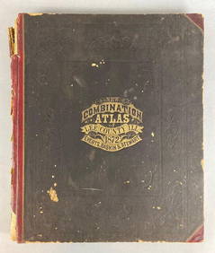
1872 New Combination Atlas of Lee County Illinois BookMatthew Bullock Auctioneers4.7(1.8k)See Sold PriceFeb 24, 2024
Arrowsmith & Lewis - Map of PolynesiaTrillium Antique Prints & Rare Books4.5(28)See Sold PriceFeb 24, 2024
Arrowsmith & Lewis - Map of North AmericaTrillium Antique Prints & Rare Books4.5(28)See Sold PriceFeb 24, 2024
Arrowsmith & Lewis - Map of the World on Mercator's ProjectionTrillium Antique Prints & Rare Books4.5(28)See Sold PriceFeb 24, 2024
Arrowsmith & Lewis - Map of LouisianaTrillium Antique Prints & Rare Books4.5(28)See Sold PriceFeb 24, 2024
Arrowsmith & Lewis - Map of the United StatesTrillium Antique Prints & Rare Books4.5(28)See Sold PriceFeb 24, 2024
Putnam - First Map of the State of Ohio by Rufus PutnamTrillium Antique Prints & Rare Books4.5(28)See Sold PriceFeb 24, 2024
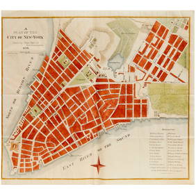
Mitchell - Map of the City of Washington (Washington, DC)Trillium Antique Prints & Rare Books4.5(28)See Sold PriceFeb 24, 2024
Carey, pub. 1796 - Map of GeorgiaTrillium Antique Prints & Rare Books4.5(28)See Sold PriceFeb 24, 2024
Carey, pub. 1796 - Map of The State of South CarolinaTrillium Antique Prints & Rare Books4.5(28)See Sold PriceFeb 24, 2024
Carey, pub. 1796 - Map of KentuckyTrillium Antique Prints & Rare Books4.5(28)See Sold PriceFeb 24, 2024
Carey, pub. 1796 - Map of the Tennassee State formerly part of North Carolina (Tennessee)Trillium Antique Prints & Rare Books4.5(28)See Sold PriceFeb 24, 2024
West Indies Islands. Guadaloupe. | Mariegalante &C. | Antigua.Jasper524.5(9.7k)See Sold PriceFeb 27, 2024
ANTIQUE VELLUM FROM 1894, FACSIMILE OF LAWS AND ACTS OF THE GENERAL ASSEMBLY OF NEW YORKNY Elizabeth 4.3(83)See Sold PriceMar 03, 2024
Robert H Labberton - Map of The Territory of the Present United States - The territory of theProverde Auctions4.3(3)See Sold PriceFeb 28, 2024


![[ATLAS]. Mitchell's New General Atlas. Phila (1 of 2)](https://p1.liveauctioneers.com/179/10971/2682697_1_x.jpg?height=282&quality=70&version=1162266334)