1952 MAY, J.F.K. HANDWRITTEN LETTER & ENVELOPEJohn McInnis Auctioneers,LLC4.6(504)See Sold PriceFeb 25, 2024
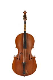
WARNER BECKMAN'S TIGER MAPLE CELLO / SEABROOK NHJohn McInnis Auctioneers,LLC4.6(504)See Sold PriceFeb 25, 2024
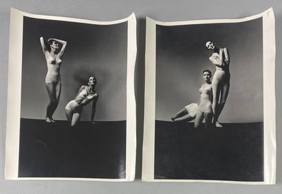
Victor Skrebneski Lingerie Fashion PhotographsEpic Auctions and Estate Sales4.6(204)See Sold PriceMar 02, 2024
[DOUGLASS, Frederick (1818-1895)]. ROBERTS, J.B., photographer. CDV of Frederick Douglass.Freeman's | Hindman4.4(1.6k)See Sold PriceFeb 27, 2024
1952 J.F.K. for SENATE TEAS & RECEPTION MATERIALJohn McInnis Auctioneers,LLC4.6(504)See Sold PriceFeb 25, 2024
HUGH D. AUCHINCLOSS' 70th BIRTHDAY with FAMILYJohn McInnis Auctioneers,LLC4.6(504)See Sold PriceFeb 25, 2024
CAROLINE KENNEDY at BAILEYS BEACH, NEWPORT, RIJohn McInnis Auctioneers,LLC4.6(504)See Sold PriceFeb 25, 2024
WILLIAM LINSMAN PHOTO SIGNED by JACKIE KENNEDYJohn McInnis Auctioneers,LLC4.6(504)See Sold PriceFeb 25, 2024
SoldMitchell Map of North America, 1755MITCHELL, John (1711-1768). A Map of the British and French Dominions in North America. Copperplate engraving with original hand color. London, 1755. In 24 segments and mounted on Linen (overall 53 1/See Sold Price
SoldFacsimile of Mitchell's 1755 map of North AmericaHeading: Author: Mitchell, John Title: The Mitchell Map of the British and French Dominions in North America 1755 Place Published: Washington Publisher:United States Geological Survey Date PubliSee Sold Price
Sold* MITCHELL, John (1711-1768). A Map of the British and* MITCHELL, John (1711-1768). A Map of the British and French Dominions in North America. London, imprint [chipped] 1755[-1757]. Engraved wall map on burlap backing, overall 1378 x 1918 mm. (Browned aSee Sold Price
Mitchell Map of America, 1755*** START PRICE IS THE RESERVE *** [America] MITCHELL, John (1711-1768). A Map of the British and French Dominions in North America. Copperplate engraving with original hand color. Engraved map with oSee Sold Price
SoldFirst Edition, First Issue of the Mitchell Map, 1755MITCHELL, John (1711-1768). A Map of the British and French Dominions in North America. [London:] Publish'd by the Author Feb.ry 13th. 1755, and Sold by And: Miller opposite Katherine Street in the StSee Sold Price
SoldMitchell Map of America, 1755 First EditionMITCHELL, John (1711-1768). A Map of the British and French Dominions of North America. Engraved map in 8 sheets. Published [London:] Publish'd by the Author Feb.ry 13th. 1755, and Sold by And: MillerSee Sold Price
Henry PoppleThe Earliest Large Scale Map of North America, the First Printed Map to Name the Thirteen Colonies, and the Best English Representation of North America Prior to John Mitchell's Landmark Map of 1755;See Sold Price
SoldMITCHELL, John, (1711-1768). A map of the British andFrench dominions in North America ... Lords Commissioners for Trade & Plantations. [Londra]: sold by And: Millar, 1755. First edition and third printing of what is considered the most important map ofSee Sold Price
Sold1800s Map British, French Dominions North AmericaMap of "The British & French Dominions in North America" -- an 1800s reprint from the 1755 original by Jonathan Mitchell. It is in very good condition measuring about 18" by 20"See Sold Price
SoldRAYNAL, GUILLAUME; and ZATTA, ANTONIO. StoriaRAYNAL, GUILLAUME; and ZATTA, ANTONIO. Storia dell' America Settentrionale. 15 double-page engraved maps, including 12 by Zatta after Mitchell's 1755 Map of the British and French Dominions in North ASee Sold Price
SoldMitchell: Map of North America, 1848North America, S. Augustus Mitchell, 1848. 13 x 15.75 inches. Great transitional map showing political boundaries within that short time period after the Canadian/U.S. boundary settlement and before tSee Sold Price
Sold1858 Mitchell Map of North America -- No. 3 Map ofTitle/Content of Map: 1858 Mitchell Map of North America -- No. 3 Map of North America Date: 1858, Philadelphia Cartographer: S Mitchell Size: 10.8 x 8.3 in. A very nice map of North and Central AmeriSee Sold Price
SoldMitchell Map of North America, 1850Excellent hand colored, engraved map of the North American continent originally created by S. Augustus Mitchell in 1850. Thomas, Cowperthwait & Co. bought out Mitchell that year. They published this mSee Sold Price
Sold1858 Mitchell Map of North America -- No 4 Map of NorthTitle/Content of Map: 1858 Mitchell Map of North America -- No 4 Map of North America Date: 1858, PhiladelphiaCartographer: S Mitchell Size: 10.4 X 8.2 in. A nice pre-Civil War map of North America, fSee Sold Price
Mitchell: Map of North America, Polar Regions, 1861Map: Map of North America. Showing Its Political Divisions, and Recent Discoveries in the Polar Regions. Definitive Northwest Passage Map Publication Date: 1861 Authors: S. Augustus Mitchell, Jr., WILSee Sold Price
Mitchell map of North America, 1862Decorative map of North America, hand-colored by country. Shows recent discoveries in Russian America, including McClure's northwest passage aboard the Investigator. Locates cities, rivers, mountains,See Sold Price
Sold1870 Mitchell Map of North America -- Map of NorthTitle/Content of Map: 1870 Mitchell Map of North America -- Map of North America Showing Its Political Divisions and Recent Discoveries in the Polar regions Date Printed: 1870, Philadelphia CartographSee Sold Price
SoldBellin map of North America 1755Heading: Author: Bellin, Jacques Nicolas Title: Carte De L'Amerique Septentrionale Depuis le 28 Degré de Latitude jusqu' au 72 Place Published: [Paris] Publisher: Date Published: 1755See Sold Price
1869 Mitchell Map of North America [verso] Eastern Canada -- III Map of North America [verso] IVTitle: 1869 Mitchell Map of North America [verso] Eastern Canada -- III Map of North America [verso] IV Dominion of Canada Cartographer: S Mithchell Year / Place: 1869, Philadelphia Map Dimension (in.See Sold Price
Mitchell map of North America, 1862Decorative map of North America, hand-colored by country. Shows recent discoveries in Russian America, including McClure's northwest passage aboard the Investigator. Locates cities, rivers, mountains,See Sold Price
1858 Mitchell Map of North America -- No. 3 Map ofTitle/Content of Map: 1858 Mitchell Map of North America -- No. 3 Map of North America Date Printed: 1858, Philadelphia Cartographer: S Mitchell Size: 10.8 x 8.3 in. A very nice map of North and CentrSee Sold Price
1869 Mitchell Map of North America [verso] EasternTitle: 1869 Mitchell Map of North America [verso] Eastern Canada -- III Map of North America [verso] IV Dominion of Canada Cartographer: S Mithchell Year / Place: 1869, Philadelphia Map Dimension (in.See Sold Price
Mitchell map of North America, 1862Reserve Reduced! Decorative map of North America, hand-colored by country. Shows recent discoveries in Russian America, including McClure's northwest passage aboard the Investigator. Locates cities, rSee Sold Price
Antique 1870 Mitchell Map of North AmericaTitle/Content of Map: 1870 Mitchell Map of North America -- Map of North America Showing Its Political Divisions and Recent Discoveries in the Polar regions Date Printed: 1870, Philadelphia CartographSee Sold Price
5 Dollars - Elizabeth II Map of North AmericaWeatherham Estate Treasures3.9(157)See Sold PriceMar 07, 2024
1849 Mitchell School ATLAS 24 MAPS America Holy Land France Africa Egypt AsiaSchilb Antiquarian Rare Books4.8(422)See Sold PriceMar 31, 2024
Arrowsmith & Lewis - Map of North AmericaTrillium Antique Prints & Rare Books4.5(30)See Sold PriceFeb 24, 2024
Map: An 18thC engraved and hand coloured map of North America and South America, titled DeClaydon Auctioneers Ltd4.3(125)See Sold PriceFeb 26, 2024
1822 MAP of NORTH & SOUTH AMERICA GEOGRAPHICAL STATISTICAL HISTORICAL antiqueJasper524.5(9.8k)See Sold PriceFeb 27, 2024
New and Correct Map of North America With the West India Islands,Jasper524.5(9.8k)See Sold PriceFeb 27, 2024
Italian edition of Sanson's map of North America, 1677PBA Galleries4.7(383)See Sold PriceMar 07, 2024
Blackie (Pub) 1882 Folio Map. United States of North AmericaAlbion Auctions4.6(341)See Sold PriceMar 01, 2024


![[DOUGLASS, Frederick (1818-1895)]. ROBERTS, J.B., photographer. CDV of Frederick Douglass. (1 of 2)](https://p1.liveauctioneers.com/197/319238/171467829_1_x.jpg?height=282&quality=70&version=1707520367)


![1869 Mitchell Map of North America [verso] Eastern Canada -- III Map of North America [verso] IV (1 of 2)](https://p1.liveauctioneers.com/5584/274166/143946195_1_x.jpg?height=282&quality=70&version=1673389176)


![1869 Mitchell Map of North America [verso] Eastern (1 of 2)](https://p1.liveauctioneers.com/5584/198775/100468071_1_x.jpg?height=282&quality=70&version=1617141175)


