2 Illuminated Books of Hours LeavesSchmidt's Antiques Inc. Since 19114.8(431)See Sold PriceMar 02, 2024
Illuminated Manuscript Leaf of The CrucifixionSchmidt's Antiques Inc. Since 19114.8(431)See Sold PriceMar 02, 2024
RARE 1930s AUTOGRAPH BOOK FEATURING RUTH & GEHRIGJohn McInnis Auctioneers,LLC4.5(505)See Sold PriceFeb 25, 2024
Timetable, Paper and Ephemera Lot-Eastern USA RailroadsJM Hobby Supply and Railroad Artifact Auctions4.4(127)See Sold PriceFeb 24, 2024
SCARCE 1971 Kim Il Sung Signed Book "ON THE WORK OF THE WOMAN'S UNION"Rbfinearts4.5(578)See Sold PriceFeb 24, 2024
1885 CIVIL WAR 1ed Famous Memoirs US Grant Sheridan Sherman 6v RARE LOT MapsSchilb Antiquarian Rare Books4.8(428)See Sold PriceMar 10, 2024
"WINTER AND SUMMER IN MAINE" 1904 PHOTO ALBUMJohn McInnis Auctioneers,LLC4.5(505)See Sold PriceFeb 25, 2024
1821 THE (3) VOYAGES of CAPT JAMES COOK VOL. I-VIIJohn McInnis Auctioneers,LLC4.5(505)See Sold PriceFeb 24, 2024
[BASEBALL]. [SHEET MUSIC]. KALBFLEISCH, J. H. The Live Oak ...Potter & Potter Auctions4.6(545)See Sold PriceMar 07, 2024
Illuminated Manuscript Leaf of The VisitationSchmidt's Antiques Inc. Since 19114.8(431)See Sold PriceMar 02, 2024
Illuminated Manuscript Leaf of GethsemaneSchmidt's Antiques Inc. Since 19114.8(431)See Sold PriceMar 02, 2024
c1700s RARE Arabic Handwritten Manuscript Middle East Persia Journal ARABIASchilb Antiquarian Rare Books4.8(428)See Sold PriceMar 10, 2024
SoldMITCHELL, JOHN. [Sheet 2, from]: A Map of the BritishMITCHELL, JOHN. [Sheet 2, from]: A Map of the British and French Dominions in North America. Double-page engraved mapsheet of the western Great Lakes region. 30¾x22¾ inches sheet size, untriSee Sold Price
SoldJohn Mitchell, (British, 1711-1768)John Mitchell, (British, 1711-1768), Plate 4 (Louisiana/Texas Sheet) from the eight-sheet "A Map of the British and French Dominions in North America with the Roads, Distances, Limits and Extent of thSee Sold Price
SoldMitchell Map of America, 1755 First EditionMITCHELL, John (1711-1768). A Map of the British and French Dominions of North America. Engraved map in 8 sheets. Published [London:] Publish'd by the Author Feb.ry 13th. 1755, and Sold by And: MillerSee Sold Price
A Map of the British and French Dominions...John Mitchell. Engraving dissected into 24 segments with original Hand Color in Full. London, 1755 (ca. 1773). 53 1/2 X 77 inches.The Most Important Map in American History. The Mitchell map of NorthSee Sold Price
SoldIndia - Walker, John, mapmaker to the East IndiaIndia - Walker, John, mapmaker to the East India Company Map of India, shewing the British London: Wm. H. Allen, 1853. Large, folded linen-backed map in 2 sheets, each sheet 87.5 x 168.2cm and dividedSee Sold Price
SoldJohn Mitchell (1711-1768)John Mitchell (1711-1768), "A Map of the British and French Dominions in North America...", c. 1760, French edition, one (of 8) hand-colored engraved sheet from Mitchell's monumental work, called theSee Sold Price
Speed Map of East Indies*** START PRICE IS THE RESERVE *** [Asia] SPEED, John (1552-1629). A New Map of East India. Engraved map. London: 1676. 17" x 21 1/2" sheet. Comparable: Bloomsbury Auctions, 2013 - £1,769. The mSee Sold Price
SoldA Map of the Province of New York...A Map of the Province of New York, with part of Pensilvania, and New England. John Montresor. engraving with original handcolor in outline (2 sheets framed). London: A. Dukes, 1775. 58 1/2 x 37 1/4 inSee Sold Price
Speed, Map of AsiaAsia. John Speed (1552-1629). Engraved map. London: G. Humble, 1626. 17 1/2 x 21 3/4 inches sheet, 26 1/2 x 31 1/2 inches framed. This beautiful carte-a-figures map is the first English printed map ofSee Sold Price
SoldSpeed Map of AmericaSPEED, John (1552-1629). America, with those known parts in that unknowne worlde. Engraved map. London: G. Humble, 1626. 17 1/4" x 21 3/4" sheet, 26 1/2" x 31 1/2" framed. English text on verso, threeSee Sold Price
SoldLea & Overton Map of AmericaA New Mapp of America...Philip Lea (fl. 1683-1700) & John Overton (1640-1713). Engraved map with original hand color in outline. London, 1688. 20 x 23 1/2 inches sheet, 29 1/2 x 33 1/4 inches framed.See Sold Price
Speed Map of AsiaSPEED, John (1551 or 1552 - 1629). Asia. Copperplate Engraved Map. From A Prospect of the Most Famous Parts of the World...with these Empires and Kingdoms. London: 1676. 17 1/8" x 22" sheet; 26 1/2" xSee Sold Price
SoldSpeed Map of AfricaAfricae, Described, the Manners of their Habits, and Buildinge…John Speed (1552-1629). Engraved map with original hand color. London: Bassett & Chiswell, 1676. 17 1/4 x 22 inches sheet, 26 1/2 x 31See Sold Price
SoldBraddock Mead Map of New EnglandA Map Of The Most Inhabited Part Of New England... 1774. Braddock Mead (aka John Green c.1688 - 1757) 2 parts, each approx. 21 1/2 x 40 1/2 inches sheet. The Finest original color possible. Braddock MSee Sold Price
SoldDeath of Capt. Cook EngravingThe Death of Captain Cook. John Webber (1751-1793). Copperplate engraving. London: Bartolozzi, 1784. 19 1/2 x 23 1/2 inches sheet, 25 x 29 1/2 inches framed.See Sold Price
SoldMontresor Map of New YorkA Plan of the City of New York & its Environs to Greenwich. George Hayward after Major John Montresor. for Valentines Manual. Lithograph. New York: G. Hayward, 1855. 25 1/2 x 20 1/4 inches sheetSee Sold Price
SoldMITCHELL, John, (1711-1768). A map of the British andFrench dominions in North America ... Lords Commissioners for Trade & Plantations. [Londra]: sold by And: Millar, 1755. First edition and third printing of what is considered the most important map ofSee Sold Price
Sold* MITCHELL, John (1711-1768). A Map of the British and* MITCHELL, John (1711-1768). A Map of the British and French Dominions in North America. London, imprint [chipped] 1755[-1757]. Engraved wall map on burlap backing, overall 1378 x 1918 mm. (Browned aSee Sold Price
John Mitchell - Map Of The British And French DominionsJohn Mitchell - Map Of The British And French Dominions In North America, 1757 - 40 X 28 In. - Gicle On Canvas - Museum Wrapped - Large Piece Of Art - This Piece Is Ready To Hang On Your WallSee Sold Price
John Mitchell - Map Of The British And French DominionsJohn Mitchell - Map Of The British And French Dominions In North America, 1757 - 40 X 28 In. - Giclée On Canvas - Museum Wrapped - Large Piece Of Art - This Piece Is Ready To Hang On Your WallSee Sold Price
JOHN MITCHELL - MAP OF THE BRITISH AND FRENCH DOMINIONSJohn Mitchell - Map Of The British And French Dominions In North America, 1757 - 40 X 28 In. - Giclée Print - Gallery Stretched - Ready to hang.See Sold Price
JOHN MITCHELL - MAP OF THE BRITISH AND FRENCH DOMJohn Mitchell - Map Of The British And French Dominions In North America, 1757 - Giclée On Canvas - 44 X 30 3/4 In. A Giclée Print Is The Highest Quality Print Available Today. Because There Is No VSee Sold Price
JOHN MITCHELL - MAP OF THE BRITISH AND FRENCH DOMINIONSJohn Mitchell - Map Of The British And French Dominions In North America, 1757 - 44 X 30 3/4 In. - Giclée Print - Gallery Stretched - Ready to hang.See Sold Price
JOHN MITCHELL - MAP OF THE BRITISH AND FRENCH DOMINIONSJOHN MITCHELL - MAP OF THE BRITISH AND FRENCH DOMINIONS IN NORTH AMERICA, 1757 - 36 x 25 1/4 in. - Museum Wrapped The Piece Of Art Is Ready To Hang Or Lean Against A Wall, Or Display On An Easel. - ASee Sold Price
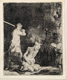
Rembrandt van Rijn. The Beheading of St. John the Baptist (1640). New Hollstein 183, III/III FairlyTremont Auctions4.5(297)See Sold PriceFeb 25, 2024
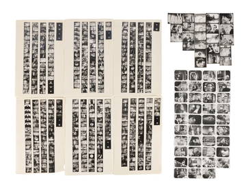
20TH C. TV & FILM ACTORS & ACTRESSES AUTOGRAPHED PHOTOSOmnia Auctions4.7(324)See Sold PriceFeb 26, 2024
Edward Weston (1886-1958), "Sandstone Erosion, Point Lobos," 1942, Gelatin silver print on paperJohn Moran Auctioneers, Inc.4.7(461)See Sold PriceFeb 27, 2024
Hand Colored Engraved Map of Europe, Jean Baptiste Bourguignon Anville 1754Global Auctions Company4.3(36)See Sold PriceMar 03, 2024
DOCTOR WHO: THE POWER OF THE DALEKS (1966) - Collection of Vintage Tele-snapsPropstore4.2(6)See Sold PriceMar 13, 2024
San Xavier Del Bac Mission, Edward S. Curtis photogravurePBA Galleries4.7(385)See Sold PriceMar 07, 2024
Herman Moll A New Map of Ye North Parts of AmericaWillow Auction House4.5(289)See Sold PriceMar 14, 2024
6 pcs Vintage Paper Maps. Vancouver Island, British Columbia. Upper Elk Creek Sheet. See pics.Crawford Family Auctions LLC4.6(122)See Sold PriceMay 25, 2024
![MITCHELL, JOHN. [Sheet 2, from]: A Map of the British First Image](https://p1.liveauctioneers.com/199/186755/93896137_1_x.jpg?height=282&quality=95&version=1606331513&width=282)

![MITCHELL, JOHN. [Sheet 2, from]: A Map of the British First Image](https://p1.liveauctioneers.com/199/186755/93896137_1_x.jpg?height=282&quality=1&version=1606331513&width=282)


![[BASEBALL]. [SHEET MUSIC]. KALBFLEISCH, J. H. The Live Oak ... (1 of 5)](https://p1.liveauctioneers.com/928/318880/171361400_1_x.jpg?height=282&quality=70&version=1707501302)


![MITCHELL, JOHN. [Sheet 2, from]: A Map of the British (1 of 1)](https://p1.liveauctioneers.com/199/186755/93896137_1_x.jpg?height=282&quality=70&version=1606331513)