SoldMid to Near East: 18 Hand colored Maps[Mid & Near East]. 18 hand-colored maps featuring Greece, Turkey, and countries in the Middle East, mostly from various editions of the Johnson Family Atlas, 1850s - 1860s. Some duplicates, each approSee Sold Price
Sold2 maps: Persia [1814] & Greece, 1752[Near East]. 2 double-page engraved maps hand-colored. Very good condition. ++ Graecia Vetus... Macedonia, Thessalia, Epirus, Achaia et Peloponesus... Engraved by G. Haussard. Paris: Robert de VaugondSee Sold Price
SoldNear East and the Nile – Country. 1847.Print of steel engraving, hand colored titled „Vorder – Asien und Nil - Land“.Author Justus Perthes.Engraved by unknown.From Justus Perthes – Stielers, „Schul-atlas“ – 1847, Germany.JustSee Sold Price
SoldMap "Nova Virginia Tabula" 17th century.Hand Colored map, by Willem Janszoon Blaeu. Amsterdam C. 1640, hand colored. Plate size 18.75" x 14 5/8", visible plate bite beyond those measurements. A very important and early map of the United StaSee Sold Price
Sold1 piece. Hand-Colored Engraved Map. Sa1 piece. Hand-Colored Engraved Map. Sanson d'Abbeville, Nicolas. "Carte Generale des Indes Orientals et des Iles Adiacentes" [South East Asia]. Paris: Pierre Mariette, [ca. 1650-1667]. 15 x 18 5/8 incSee Sold Price
SoldBRITISH & AMERICAN TROOPS NEAR SARATOGA 1777Copper-engraved map/battle plan. 8.75 BY 18.5 inches. hand colored plan showing the disposition of British troops under Lt. General Burgoine at Saratoga along the Hudson's River, with the surroundingSee Sold Price
SoldEuropean & British Isles Map 18th C.Germany, France, Italy, Spain & British Isles Map . Mons. D'Anville. 1771. Hand-colored. ; 20" x 18 1/2"See Sold Price
SoldHand Colored 'Gulf of Bengal' MapHand Colored 'Gulf of Bengal' Map c.1700, showing the east coast of India and Ceylon (Sri Lanka), oriented to the west by Jan Jansson Height: 18.25 inches, Width: 21.25 inches (sight) Frame Size: 27.0See Sold Price
Sold1700's 1800's Map Africa Egypt Mid East1700's or 1800's map of Africa, Egypt, Mid-East, Libya etc. Measures 18" x 24" and has been professionally framed. Hand watercolored. Plate TXXXI .See Sold Price
SoldTwo Maps by A. J. Johnson, consisting of " NorthTwo Maps by A. J. Johnson, consisting of " North America," 1861, hand colored, h.- 27 in., W.- 18 1/8 in.; together with "Canada, East or Lower Canada and New Brunswick," 1863-1869, H.- 11 7/8 in., W.See Sold Price
Antique Celestial Map Illustrated Plate BootesThe antique star map / celestial map with illustrated constellations and hand colored in watercolor. Sight size 13.75" x 18 5/8". Framed. With Quadrants Muralis, Bootes, Canes Venatici, Coma BerenicesSee Sold Price
SoldAntique Map Of Italian Papal States Near RomeProbably 17th Century, Hand Colored Engraving With Patrimonio Di S. Pietro Sabina Et Ducato Di Castro, Sight 14 X 18 Inches, Later Frame 19 X 23 X 1 Inches. See Photos For Condition.See Sold Price
SoldA lot of three 17th century colored maps3 (Three) seventeenth century colored maps, the first "Carte du Pais de Saintonge" by LeClerc, mid 17th century, hand colored engraving on laid paper, hinged to board, 14in x 18.25in, the next "Tab. ISee Sold Price
Part of Sections Two, New York City MapDepicts Lower East Side. Plate 8. 1902. G.W. Bromley & Co. Philadelphia. Hand-colored lithograph. ; 22 1/2" x 32"See Sold Price
Part of Section Two, New York City MapDepicts Lower East Side. Plate 12. 1902. G.W. Bromley & Co. Philadelphia. Hand-colored lithograph. ; 22 1/2" x 32"See Sold Price
SoldMap, Old England, 17th/18th centuryFramed handcolored engraving, "Warwicum Northamtonia Huntingdonia Cantabrigia...", depicting the south-east England, by Gerard Mercator/Jodocus Hondius, 1628 issue, plate: 14 5/8"H x 18.5"WSee Sold Price
SoldMitchell's School Atlas 1854, hand-colored mapsTitle: Mitchell's School Atlas: Comprising the Maps and Tables Designed to Accompany Mitchell's School and Family Geography Author: Mitchell, [Samuel Augustus] Description: With 18 hand-colored maps (See Sold Price
Sold[Eastern Europe/Near East] 18 Maps & Views.[Eastern Europe/Near East] 18 Maps & Views. Engravings (12) by Gabriel Bodenehr (1664-1758), c1737. 12 x 7 7/8, off-white laid. Legend in German. Some toning and staining, light foxing around the bordSee Sold Price
SoldMitchell's School Atlas 1855, w/ 18 colored mapsTitle: Mitchell's School Atlas: Comprising the Maps and Tables Designed to Accompany Mitchell's School and Family Geography Author: Mitchell, S[amuel] Augustus Description: With 18 hand-colored maps (See Sold Price
SoldMitchell's School Atlas 1858, hand-colored mapsTitle: Mitchell's School Atlas: Comprising the Maps and Tables Designed to Accompany Mitchell's School and Family Geography Author: Mitchell, [Samuel Augustus] Description: With 18 hand-colored maps (See Sold Price
SoldMitchell's School Atlas 1854, hand-colored mapsTitle: Mitchell's School Atlas: Comprising the Maps and Tables Designed to Accompany Mitchell's School and Family Geography Author: Mitchell, [Samuel Augustus] Description: With 18 hand-colored maps (See Sold Price
SoldWith U.S. map showing independent TexasHeading: (Atlas) Author: Smith, Roswell C. Title: Smith's Atlas Place Published: Hartford Publisher:Spalding and Storrs Date Published: 1939 Description: With 18 hand-coloreSee Sold Price
SoldJohnson: Antique Map of Arkansas & Louisiana, 1868Title/Content of Map: Johnson's Arkansas, Mississipi & Louisiana Date Printed: 1868 Cartographer: A. J. Johnson Material/Medium: Paper Size: 24" x 18" Hand colored engraved Map. From Johnson's New IllSee Sold Price
SoldJohnson: Antique Map of the World, 1868Title/Content of Map: World by Johnson Date Printed: 1868 Cartographer: A.J. Johnson Material/Medium: Paper Size: 23 1/2" x 18" Hand colored engraved Map. From Johnson's 'New Illustrated Family AtlasSee Sold Price
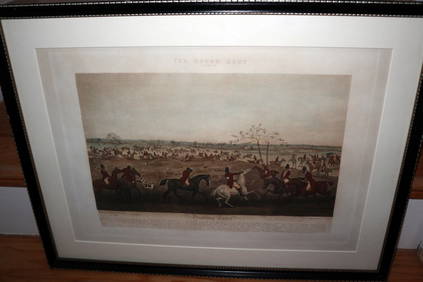
HENRY ALKEN / LEWIS Original 1835 Hand Colored Engraving Quorn Hunt DrawingLuis Porretta Fine Arts4.3(10)See Sold PriceMar 02, 2024
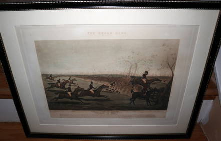
HENRY ALKEN / LEWIS Original 1835 Hand Colored Engraving Quron Hunt Snob Is BeatLuis Porretta Fine Arts4.3(10)See Sold PriceMar 02, 2024
MARTIN VILLALBA Three Baristas Limited Ed 11/50 Engraving Hand ColoredLuis Porretta Fine Arts4.3(10)See Sold PriceMar 02, 2024
Japanese Woodblock hand Colored c19150 6 x Floor PagodaLuis Porretta Fine Arts4.3(10)See Sold PriceMar 02, 2024
Japanese Woodblock Print Hand Colored Sealed Cheery BlossomLuis Porretta Fine Arts4.3(10)See Sold PriceMar 02, 2024
Japanese Woodblock c1950 Hand Colored Kegon Falls 10" x 7" SealedLuis Porretta Fine Arts4.3(10)See Sold PriceMar 02, 2024
Japanese Woodblock c1950 Valley Of Trees Hand Colored 10" x 7"Luis Porretta Fine Arts4.3(10)See Sold PriceMar 02, 2024
Massimo Campigli "Primo Studio" Hand-Colored LithoAuctions at Showplace4.5(726)See Sold PriceMar 12, 2024
[ARCTIC]. BOWEN, Emanuel. A New & Accurate Map of the North...Potter & Potter Auctions4.6(539)See Sold PriceMar 07, 2024
[MAPS]. DUFOUR, Auguste-Henri (1795-1865). Bound Volume of ...Potter & Potter Auctions4.6(539)See Sold PriceMar 07, 2024
[MAP]. [ALBRIZZI, Giambatista, 1698-1777]. Carta Geografica...Potter & Potter Auctions4.6(539)See Sold PriceMar 07, 2024
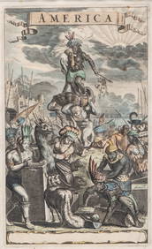
Antique Hand Colored Print "America" by Jacob van MeursCollective Hudson4.5(54)See Sold PriceMar 01, 2024
Framed Hand Colored Antique Map of the Department of Nord, FranceDonny Malone Auctions4.5(1.7k)See Sold PriceMar 04, 2024
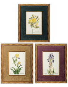
Georg Wolfgang Knorr (German, 1705-1761), Three Antique Hand Colored Botanical Engravings ofHoch LTD.4.5(73)See Sold PriceFeb 25, 2024
1849 Hand Colored Blair Map of World in HemispheresMatthew Bullock Auctioneers4.7(1.8k)See Sold PriceMar 02, 2024
1849 Orr & Co. Hand Colored Southern Germany MapMatthew Bullock Auctioneers4.7(1.8k)See Sold PriceMar 02, 2024


![2 maps: Persia [1814] & Greece, 1752 (1 of 2)](https://p1.liveauctioneers.com/179/14187/4432374_1_x.jpg?height=282&quality=70&version=1193335524)


![[Eastern Europe/Near East] 18 Maps & Views. (1 of 2)](https://p1.liveauctioneers.com/179/1435/617488_1_x.jpg?height=282&quality=70)


![[ARCTIC]. BOWEN, Emanuel. A New & Accurate Map of the North... (1 of 1)](https://p1.liveauctioneers.com/928/318880/171360917_1_x.jpg?height=282&quality=70&version=1707501302)
![[MAPS]. DUFOUR, Auguste-Henri (1795-1865). Bound Volume of ... (1 of 2)](https://p1.liveauctioneers.com/928/318880/171361279_1_x.jpg?height=282&quality=70&version=1707501302)
![[MAP]. [ALBRIZZI, Giambatista, 1698-1777]. Carta Geografica... (1 of 1)](https://p1.liveauctioneers.com/928/318880/171361280_1_x.jpg?height=282&quality=70&version=1707501302)