MATTHEWS c1856 Map Of Upper Canada Ontario Indian Land Agency Divisions Scarce!Luis Porretta Fine Arts4.3(10)See Sold PriceMar 02, 2024
DEVINE c1856 Dr Salters Map Of Lake Huron Ontario Indian Lands etc. No. 7 ScarceLuis Porretta Fine Arts4.3(10)See Sold PriceMar 02, 2024
DUNLEVIE c1856 Map Counties Of Gaspe & Bonaventure Quebec Canada SCARCE! #1Luis Porretta Fine Arts4.3(10)See Sold PriceMar 02, 2024
DUNLEVIE c1856 Map Counties Of Gaspe & Bonaventure Quebec Canada SCARCE! #2Luis Porretta Fine Arts4.3(10)See Sold PriceMar 02, 2024
Map UNITED COUNTIES LEEDS & GRENVILLE by Walling 1861 Rare Canada Map 5ft x 5ftLuis Porretta Fine Arts4.3(10)See Sold PriceMar 02, 2024
Ambroise TARDIEU c1822 Map Venice Napoleon Italian Campaign 17" x 11"Luis Porretta Fine Arts4.3(10)See Sold PriceMar 02, 2024
SoldMeyer: Antique Map, the Carolinas Georgia Florida, 1850Map: Die Staaten von N. & S. Carolina, Georgia & Florida Cartographer: Bibliographischen Instituts. Place & Date: Hildburghausen / 1850 Size: 7 3/4" x 10" Condition: original color; overall age toningSee Sold Price
Meyer: Antique Map of Carolinas Georgia Florida, 1846Map: Die Staaten N. & S. Carolina Georgia & Florida Cartographer: Bibliograph. Instituts. Place & Date: Hildburghausen / 1846 Size: 7 3/4" x 10 1/8" Condition: original color; overall age toning A fasSee Sold Price
Bellin: Antique Map of French Florida Georgia CarolinasTitle/Content of Map: Karte von den Kusten des Franzoisischen Florida Cartographer: Bellin Place & Date: Leipzig / 1756 Size: 5 3/4" x 8" Condition: b&w; light overall age toning Bellin's very interesSee Sold Price
SoldTardieu: Antique Map of Florida & Georgia, 1798Map: Carte de la Floride et de la Georgie Cartographer: Chanlaire & Mentelle / Tardieu Place & Date: Paris / 1798 Size: 16 3/4" x 13" The dramatic Florida map, with Georgia and parts of the CarolinasSee Sold Price
Meyer: Antique Map of Arkansas 1850Neueste Karte von Arkansas 1850 The beautifully detailed and colored map of Arkansas "with its canals, streets, etc.," from Meyer's Auswanderungs-Atlas (Emigrant's Atlas) of North America. Includes aSee Sold Price
SoldLOT OF 3 ANTIQUE MAPS 1850 FLORIDA SURVEY MAPSTwo 1850's North Florida survey maps, Arredondo Grant and South Boundary of General Coffees Survey. Both framed, measuring 15 X 8 inches. Lot also includes Diagram of Tallahassee Land District map, frSee Sold Price
SoldBellin: Antique Map of the Carolinas and Georgia, 1757Map: Carte de la Caroline et Georgie Cartographer: Bellin Place & Date: Paris / 1757/1760 Size: 11 1/8" x 7 3/8" Condition: b&w; overall age toning; some spotting and staining; a tiny repaired puncturSee Sold Price
Mitchell: Antique Map of Florida & the Carolinas, 1860Title/Content of Map: 1860 Mitchell Map of Florida, South and North Carolina -- County Map of Florida on page with Map of South Carolina, on page with County Map of North Carolina Date Printed: 1860,See Sold Price
Meyer: Antique Map of New England with Insets, 1850Map: Die Staaten von Maine, New Hampshire, Massachusetts, Vermont, Connecticut & Rhode I. Cartographer: Bibliographischen Instituts. Place & Date: Hildburghausen / 1850 Size: 7 7/8" x 10 5/8" ConditioSee Sold Price
Bonne: Antique Map of the Carolinas, 1780Title/Content of Map: 'Carte de la Partie Sud des Etats Unis de l'Amérique Septentrionale' A map of the Carolinas & Georgia Date Printed: 1780 Image Size: Approx 23.0 x 34.0cm, 9 x 13.5 inches (LargeSee Sold Price
SoldGraessl: Antique Map of U.S. Southeast with city insetsDie Staaten N. & S. Carolina Georgia & Florida. A fascinating and beautifully colored map of the southeastern states of the U.S. in 1846, with inset maps of the "Gold Region of North Carolina" and theSee Sold Price
Bonne: Antique Map of the Carolinas, 1780TITLE/CONTENT OF MAP: 'Carte de la Partie Sud des Etats Unis de l'Amérique Septentrionale' A map of the Carolinas & Georgia DATE PRINTED: 1780 IMAGE SIZE: Approx 23.0 x 34.0cm, 9 x 13.5 inches (LargeSee Sold Price
Antique Map - Southern States - 1898Antique Map - Southern States (Eastern section) - 1898 featuring North Carolina, South Carolina, Tennessee, Georgia, Florida, Alabama & Mississippi. Size : 10.75" x 8.75"See Sold Price
Antique Map - Southern States - 1898Antique Map - Southern States (Eastern section) - 1898 featuring North Carolina, South Carolina, Tennessee, Georgia, Florida, Alabama & Mississippi. Size : 10.75" x 8.75"See Sold Price
SoldBellin: The Carolinas, Georgia, North FloridaMap Title: Karte von den Kusten des Franzoisischen Florida Cartographer: Bellin Place & Date: Leipzig / 1756 Size: 5 3/4" x 8" Condition: b&w; light overall age toning Bellin's very interesting map ofSee Sold Price
Ettling: Antique Map of USA SOUTH EAST, 1863TITLE/CONTENT OF MAP: 'United States of North America (Eastern & central)' USA SOUTH EAST. Florida Georgia Carolina coast Bahamas DATE PRINTED: 1863 IMAGE SIZE: Approx 44.5 x 32.0cm, 17.5 x 12.5 incheSee Sold Price
Map of Florida, Southeast U.S.,Parte Orientale della Florida, della Giorgia, e Carolina en Meridionale, showing coast of Carolinas, Georgia and Florida, attributed to Zatta Venice, 1778, 14-1/2 x 20-1/2 in., painted and gilt wood fSee Sold Price
SoldBellin,18th C. French Map of Carolinas & GeorgiaOrnamental title cartouche lower right "Carte De La Caroline Et Georgie"; hand-colored engraving by J. Bellin, Paris, 1757; Southern Virginia to North Florida including Carolinas and Georgia; shows moSee Sold Price
USA SOUTH EAST. Florida Georgia Carolina coast Bahamas.TITLE/CONTENT OF MAP: 'United States of North America (Eastern & central)' DATE PRINTED: 1862 IMAGE SIZE: Approx 44.5 x 32.0cm, 17.5 x 12.5 inches (Large) TYPE: Antique map with original outline colouSee Sold Price
SoldZatta: Antique Map of English Louisiana, Florida, 1778Map: Luigiana Inglese, colla parte Occidentale, della Florida, della Georgia, e Carolina Merid[i]onale Cartographer: Zatta Place & Date: Venice / 1778 Size: 16 1/2" x 12 1/2" Condition: Original colorSee Sold Price
SoldHOMANN HEIRS MAP, "DOMINIA ANGLORUM IN AMERICAHOMANN HEIRS MAP, "DOMINIA ANGLORUM IN AMERICA SEPTENTRIONALI SPECIALIBUS" SHOWING NEW ENGLAND, CHESAPEAKE, GEORGIA, CAROLINAS, FLORIDA AND NOVA SCOTIA, C.1740. SIGHT 20 X 23"; FRAMED AND GLAZEDSee Sold Price
Sold3 Maps incl: D. Carolina nebsteinem... [ca. 1740].[Southeast/Carolinas/FL]. 2 Maps. Matted and framed under glass. Not examined out of frames. ++ D. Carolina nebsteinem Theil von Florida. Shows the Carolinas (including Georgia), with Florida above thSee Sold Price
SoldBellin: Antique Map of Carolina & Georgia, 1757Map: Carte de la Caroline et Georgie Cartographer: Bellin Place & Date: Paris / 1757 Size: 11 1/8" x 7 3/8" Condition: b&w Bellin's highly detailed map of Georgia and the Carolinas with an elegant titSee Sold Price
SoldFour Late 18th Century Regional Maps of North Americafrom his Histoire General des Voyages, 1757, copperplate engravings with outline color, the maps variously depicting New England, the Chesapeake Bay, the Carolinas and Georgia, Louisiana and Florida.See Sold Price
Duval - Pair: Map of Georgia & Map of Moscow, RussiaTrillium Antique Prints & Rare Books4.5(30)See Sold PriceFeb 24, 2024
Carey, pub. 1796 - Map of GeorgiaTrillium Antique Prints & Rare Books4.5(30)See Sold PriceFeb 24, 2024
Catesby, Folio - Tumble-Turds (Dung Beetle) with Canada Lily. Sup-11Trillium Antique Prints & Rare Books4.5(30)See Sold PriceFeb 24, 2024
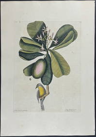
Catesby, Folio - American Goldfinch with Acacia. 1-43Trillium Antique Prints & Rare Books4.5(30)See Sold PriceFeb 24, 2024
Catesby, Folio - Bahama Titmouse with Seven Years Apple. 1-59Trillium Antique Prints & Rare Books4.5(30)See Sold PriceFeb 24, 2024
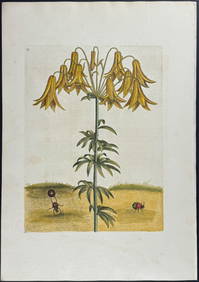
Catesby, Folio - American Partridge with Attamusco Lily. Sup-12Trillium Antique Prints & Rare Books4.5(30)See Sold PriceFeb 24, 2024
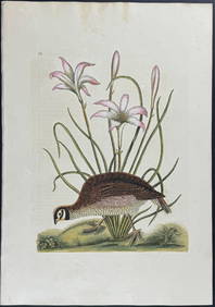
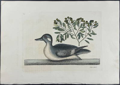
Catesby, Folio - Little Brown Duck with Soap-Wood. 1-98Trillium Antique Prints & Rare Books4.5(30)See Sold PriceFeb 24, 2024
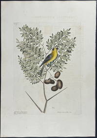
Catesby, Folio - Red Bellied Woodpecker & Hairy Woodpecker with Black Oak. 1-19Trillium Antique Prints & Rare Books4.5(30)See Sold PriceFeb 24, 2024
Carte de L'Algérie et de la Régence de Tunis' ANDRIVEAU-GOUJON Algeria 1850 mapJasper524.5(9.8k)See Sold PriceFeb 28, 2024
Joseph Meyer - Set of 50 Prints - Views of Austria - Germany - Italy - Sweden - France - CzechProverde Auctions4.3(3)See Sold PriceFeb 28, 2024
Joseph Meyer - Set of 50 Prints - Views of Austria - Germany - Italy - Sweden - France - UnitedProverde Auctions4.3(3)See Sold PriceFeb 28, 2024


![3 Maps incl: D. Carolina nebsteinem... [ca. 1740]. (1 of 3)](https://p1.liveauctioneers.com/179/41615/18011248_1_x.jpg?height=282&quality=70&version=1369948904)