SoldMcKelvie/Harrison.Game Birds..British IslesHarrison (J.C.).- McKelvie (Colin). The Game Birds of the British Isles,number 66 of 475 copies, 25 colour plates by J.C.Harrison, tissue guards, original half morocco, gilt, g.e., slip-case,See Sold Price
Sold1823 SCOTTISH Literature Sir Walter Scott Lady of Lake Lord of Isles 10v SET1823 SCOTTISH Literature Sir Walter Scott Lady of Lake Lord of Isles 10v SET “My hope, my heaven, my trust must be, My gentle guide, in following thee.” – Sir Walter Scott, Lady ofSee Sold Price
Sold1888 Isles of Pacific Ocean New Zealand Fiji Tahiti1888 Isles of Pacific Ocean New Zealand Fiji Tahiti Easter Island Moai Hawaii “The Isles of the Pacific” is a late 19th-century history of the geography and wonders of the islands in the South PacSee Sold Price
SoldA MAP, "ARCHIPELAGUE DU MEXIQUE OU SONT LES ISLES DEA MAP, "ARCHIPELAGUE DU MEXIQUE OU SONT LES ISLES DE CUBA, ESPAGNOLE, IAMAÏQUE, &C," CÓVENS, JEAN, AMSTERDAM [1757?]. Caribbean area and New Spain. Includes insets of Vera Cruz, Havana, "Baye de PorSee Sold Price
SoldA New Map of the West India Isles, Carey, 1687A New Map of the West India Isles. The beautifully colored, highly detailed West Indies map from Cary's New Universal Atlas encompasses Florida and southeastern North America, part of Mexico, all of CSee Sold Price
Sold1884 Isles of Shoals New England Native American Coloni1884 Isles of Shoals New England Native American Colonial Americana John Smith John S Jenness’s ‘The Isles of Shoals’ is a historical view of the small group of islands of the New England coastSee Sold Price
SoldTOBIAS LOTTER MAP OF BRITISH ISLESOriginal hand-colored engraving. 18th century. Three different hand-colored heraldic devices. Dimensions: (Frame) H 30.5" x W 26.5", (Sight) H 23.75" x W 20" Condition: Some light foxing. Unexamined oSee Sold Price
British Isles, Pieter Goos 1665-66Title: Pas-Caart vant Canaal Vertoonende in 't Gheheel Engelandt, Schotlandt, Yrlandt, en een Gedeelte van Vrancryck Subject: British Isles Maker: Pieter Goos Date: 1665-66, Amsterdam Materials: HandSee Sold Price
SoldIsles du Japon & presquIsle de Corée. Japan Korea ChinaTITLE/CONTENT OF MAP: 'Carte des Isles du Japon, & la Presqu Isle de Corée, avec les Côtes de la Chine, depuis Pékin jusquà Canton [Map of the Islands of Japan, and the peninsula of Korea, with thSee Sold Price
SoldJOHN W. HATCH (1919-1998) Isles of Shoals"Black Crowned Night Heron Isles of Shoals" watercolor 26 x 20 inches, annotated verso, unframed. Estate stamped.See Sold Price
SoldBellin: Carte des Isles Bermudes ou de Sommer, 1764Map: Carte des Isles Bermudes ou de Sommer Cartographer: Bellin Place & Date: Paris / 1764 Size: 12 3/4" x 8" The uncommon and beautifully detailed map of Bermuda divided into parishes, from Bellin'sSee Sold Price
Sold1787 HAND COLORED LES ISLES ANTILLESAntique 1787 Hand Colored Map - Les Isles Antilles et le Golfe Du Mexique [Bermuda Inset] By Rigobert Bonne. Detailed map of the Caribbean, Florida, Gulf Coast and Central America, showing islands, cuSee Sold Price
SoldMy Isles of Golden Dreams Fox Trot RCA Victor PosterDardanella Waltz Selvins Novelty Orchestra poster is approx 16 1/2" x 24 1/2"See Sold Price
Sold1855 1st ed SCOTLAND The Isles of Loch Awe English1855 1st ed SCOTLAND The Isles of Loch Awe English Poems Illustrated Castles ‘The Isles of Loch Awe’ is a collection of English poems, collected and edited by Philip Gilbert Hamerton. This ratherSee Sold Price
SoldCarte du Canal des Isles Philippines, G. Anson 1749Title: Carte du Canal des Isles Philippines Subject: Philippines Maker: George Anson Date: 1749, London Size: 21 x 16.5 inches Chart of the Philippines showing the route of the Spanish treasure ships,See Sold Price
Sold1889 1ed ZigZag Journeys British Isles Liverpool Lands End London Bridge CASTLES1889 1ed ZigZag Journeys British Isles Liverpool Lands End London Bridge CASTLES American author Hezekiah Butterworth is best remembered for his enormous, seventeen volume work Zig-Zag Journeys. WrittSee Sold Price
SoldNOUVEAU VOYAGE AUX ISLES DE L'AMERIQUE 1722Jean-Baptiste Labat. Pierre-Francois Giffart Paris. 5 vol. hard cover leather bound. 6 1/4 x 4 inches.See Sold Price
Sold1695 Morden Map of the British Isles in Roman Times --Title/Content of Map: 1695 Morden Map of the British Isles in Roman Times -- Britannia Romana Date: 1695, London Cartographer: R Morden Size: 14 X 16.8 in. This is a handsome map of the British IslesSee Sold Price
Sold1796 MAP OF THE BRITISH ISLESItalian map. Caleographia Camerale. Engraving. Dimensions: (Frame) H 22.25"x W 16.75", (Sight) H 21.25" x W 15.75" Condition: Some creases to paper.See Sold Price
SoldAntique Map, "West India Isles", a new map of the WestAntique Map, "West India Isles", a new map of the West India Isles from the latest Authorities, by John Cary,engraver, 1803, framed, 18.5" by 20.5". Notice: Please note that our auctions will continueSee Sold Price
SoldThomas Clerk EAST INDIA ISLES MAP 1817 Antique EngravedThomas Clerk EAST INDIA ISLES MAP 1817 Antique Engraved Hand‐Colored Map John Thomson & Co. John Thomson Junr. & Co. Edinburgh Cartography Indian Ocean China Sea Philippine Islands PacifSee Sold Price
Janssonius: Sea Chart of British Isles, Gold Leaf, 1660Title: Pascaart vant Canaal, Tusschen Engelant en Vrancryck, alsmede ge heel Ierlant en Schotlant Map maker: J. Janssonius, Atlantis Majoris Quinta Pars Orbem Maritimum Place and Year: Amsterdam, 1660See Sold Price
SoldOrtelius: Crete & Mediterranean IslesMap Title: Creta Cartographer: Ortelius Place / Date: Antwerp / 1621 Size: 19 1/4" x 13 1/4" Condition: outline color; overall age-toning, light browning along outer edge of upper margin The superb maSee Sold Price
SoldFOLIO ATLAS- "DESCRIPTION EXACTE DES ISLES DE L'ARFOLIO ATLAS- "DESCRIPTION EXACTE DES ISLES DE L'ARCHIPEL ET DE QUELQUES AUTRES ADJACENTES...", DAPPER, PUBLISHED BY GEORGE, AMSTERDAM FIRST FRENCH ED., 1703 (LEATHER RE-BIND)See Sold Price
A Group of Knitting Patterns, Including Fair Isle and Fisherman Sweaters (63 total)Nazmiyal Auctions4.4(34)See Sold PriceFeb 26, 2024
1917 Isle Of Man Internment Camp Douglas Cover To London England Judaica WWIMynt Auctions4.6(680)See Sold PriceFeb 26, 2024
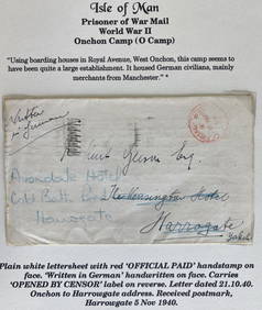
1940 Isle Of Man England Prisoner War POW Onchon Camp Letter Cover To HarrogateMynt Auctions4.6(680)See Sold PriceFeb 27, 2024
AN ANTIQUE FOLDING MAP OF THE BRITISH ISLES DATED 1873Hutchinson Scott Auctioneers4.4(39)See Sold PriceFeb 28, 2024
Antique Belle Isle Michigan Bath House Aquarium Casino Painted Zinc Sign Ca. 1900Holler and Hammer4.5(47)See Sold PriceFeb 24, 2024
1999 Isle of Man GOLD QUEEN ELIZABETH & Cat 1/10 oz .999 Fine GOLD Coin.Westside Traders Emporium4.5(34)See Sold PriceFeb 27, 2024
Chatelain - 3 Maps of the British Isles (England, Ireland, Scotland)Trillium Antique Prints & Rare Books4.5(30)See Sold PriceFeb 24, 2024
De Jode, Rare, pub. 1593 - Map of the British Isles [England, Scotland, Ireland] (Angliae Scotiae etTrillium Antique Prints & Rare Books4.5(30)See Sold PriceFeb 24, 2024
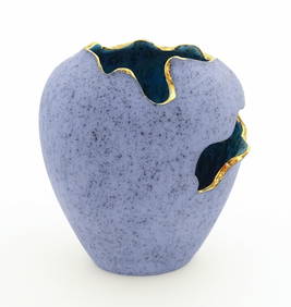
A modern Scottish studio pottery Torn Pot vase by Carbostcraft Pottery, Isle of Skye. Designed byClaydon Auctioneers Ltd4.3(125)See Sold PriceFeb 25, 2024
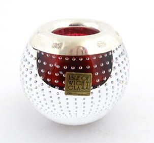
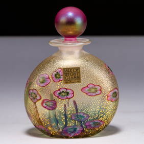
An Isle of Wight glass match holder with silver rim hallmarked Sheffield 2003. Signed lower. Approx.Claydon Auctioneers Ltd4.3(125)See Sold PriceFeb 25, 2024
Map: A 17thC engraved map of the British Isles titled A Generall Mapp of the Isles of GreatClaydon Auctioneers Ltd4.3(125)See Sold PriceFeb 26, 2024
1764 Bellin Map of Lesser Antilles Northern Portion -- Petites Antilles ou Isles du Vent 3e. Partie.Jasper524.5(9.8k)See Sold PriceFeb 27, 2024
1683 Sanson Map of the Caribbean -- Les Isles Antilles, &c Entre Lesquelles sont les Lucayes, et lesJasper524.5(9.8k)See Sold PriceFeb 27, 2024
2023 Isle of Man 2 oz Silver Noble Piedfort Ultra High ProofPacific Global Auction3.9(272)See Sold PriceFeb 26, 2024
Stanford, Edward 1901 Large Map. Geological Map of the British IslesAlbion Auctions4.6(336)See Sold PriceMar 01, 2024
Stanford, Edward 1901 Large Map. Hydrographical Map of the British IslesAlbion Auctions4.6(336)See Sold PriceMar 01, 2024
Stanford, Edward 1901 Large Map. Stereographical Map of The British IslesAlbion Auctions4.6(336)See Sold PriceMar 01, 2024
Paterson & Mogg 1822 Pair of British Road Maps. Isle of Thanet & WightAlbion Auctions4.6(336)See Sold PriceMar 01, 2024
James Cook - Map of the Friendly Isles - Tonga IslandsProverde Auctions4.3(3)See Sold PriceFeb 28, 2024
Antique Map of France, 1703 by Gillaume Del Isle PrintAntiques Online Auctions4.6(407)See Sold PriceMar 14, 2024
Isle of Skye-21 year old (1) Grand Slam Dram-10 year old (4) Famous Grouse Vintage Malt Whisky...Bonhams4.1(305)See Sold PriceFeb 26, 2024


![De Jode, Rare, pub. 1593 - Map of the British Isles [England, Scotland, Ireland] (Angliae Scotiae et (1 of 2)](https://p1.liveauctioneers.com/6581/319571/171593327_1_x.jpg?height=282&quality=70&version=1707853304)