17TH C. ENGLISH LINEAR MAP BY OGILBY, FRAMEDThomaston Place Auction Galleries4.4(386)See Sold PriceFeb 24, 2024
MAP - PIETER SCHENK / VALK / JANSSEN Hand Colored superb Map Central Italy c1702Luis Porretta Fine Arts4.3(10)See Sold PriceMar 02, 2024
OGILVY & BOWEN c1736 Original Map of Oxfordshire Berkshire Etc.Luis Porretta Fine Arts4.3(10)See Sold PriceMar 02, 2024
CHARLES ROLLIN c1828 Ceasar Hand Colored Africa Military MapLuis Porretta Fine Arts4.3(10)See Sold PriceMar 02, 2024
MAP - Dufour, A. H. ( Malte / Brun ) :MAP - ESPAGNE PARTIE SUD DIVISEE EN PROVINCES ANCIENNES ( MAPLuis Porretta Fine Arts4.3(10)See Sold PriceMar 02, 2024
RIGOBERT BONNE c1787 Original Colored Map Germany & Region 15" x 12"Luis Porretta Fine Arts4.3(10)See Sold PriceMar 02, 2024
AMBROISE TARDIEU c1822 Napoleonic War Map GermanyLuis Porretta Fine Arts4.3(10)See Sold PriceMar 02, 2024
MAP - AMBROISE TARDIEU c1822 Napoleonic Miltary Map GermanyLuis Porretta Fine Arts4.3(10)See Sold PriceMar 02, 2024
1822 Rare Map by Ambroise Tardieu Napoleon Caldiero Battle of Vento 17" x 11Luis Porretta Fine Arts4.3(10)See Sold PriceMar 02, 2024
THOMAS MOULE 1837 Colored Map of Warwickshire Framed vgcLuis Porretta Fine Arts4.3(10)See Sold PriceMar 02, 2024
PIETER SCHENK / VALK / JANSSEN Hand Colored Map of Rhodes Greece ca1702 vgcLuis Porretta Fine Arts4.3(10)See Sold PriceMar 02, 2024
STICH & DRUCK c1888 Map Austrian Alps 20" x 16"Luis Porretta Fine Arts4.3(10)See Sold PriceMar 02, 2024
Mawman: Antique Map of Greece, Sparta, 1791Title/Content of Map: Greece: Sparta & Environs, 1791 Date Printed: 1791 Cartographer: J. Mawman Material/Medium: Engraving Size: 10 1/4" x 15 1/4" Original copper engraving from the 1791 book Maps, PSee Sold Price
Mawman: Antique Map of Greece, Boeotia, 1791Map: Greece: Boeotia Date: 1791 Maker: J. Mawman Medium: Original copper engraving Size: 10 1/4" x 15 1/4" From the 1791 "Maps, Plans, Views, and Coins Illustrative of the Travels of Anacharsis the YoSee Sold Price
Mawman: Antique Map of Greece, Thessaly, 1791Title/Content of Map: Greece: Thessaly, 1791 Date Printed: 1791 Cartographer: J. Mawman Material/Medium: Engraving Size: 10 1/4" x 15 1/4" Original copper engraving from the 1791 book Maps, Plans, VieSee Sold Price
SoldMawman: Antique Map Plan of Athens, Greece, 1791Original copper engraving from the 1791 "Maps, Plans, Views, and Coins Illustrative of the Travels of Anacharsis the Younger in Greece". by J. Mawman, 1805. Plan of the Academy & Environs for the travSee Sold Price
SoldMawman: Antique Map Plan of Athens, Greece, 1791Original copper engraving from the 1791 "Maps, Plans, Views, and Coins Illustrative of the Travels of Anacharsis the Younger in Greece". by J. Mawman, 1805. Plan of the Athens for the travels of AnachSee Sold Price
Mawman: Antique Map of Aetolia & Acarnania Greece, 1791Title/Content of Map: Greece: Aetolia & Acarnania in Penninsula of Leucadia, 1791 Date Printed: 1791 Cartographer: J. Mawman Material/Medium: Engraving Size: 10 1/4" x 15 1/4" Original copper engravinSee Sold Price
SoldMawman: Antique Map Plan of Athens, Greece, 1791Original copper engraving from the 1791 "Maps, Plans, Views, and Coins Illustrative of the Travels of Anacharsis the Younger in Greece". by J. Mawman, 1805. Plan of the Athens for the travels of AnachSee Sold Price
Mawman: Antique Map of Greece, The Hellespont, 1791Title/Content of Map: Greece: The Hellespont, Thracian Chersonesus & Troas, 1791 Date Printed: 1791 Cartographer: J. Mawman Material/Medium: Engraving Size: 10 1/4" x 15 1/4" Original copper engravingSee Sold Price
Mawman: Antique Map of Greece: Battle Plan of SalamisMap: Greece: Battle Plan of Salamis Maker: J. Mawman Date: 1791 Medium: Original copper engraving Size: 10 1/4" x 15 1/4" From the 1791 "Maps, Plans, Views, and Coins Illustrative of the Travels of AnSee Sold Price
Mawman: Antique Map of Greece: Battle of PlataeaTitle/Content of Map: Greece: Battle of Plataea, 1791 Date Printed: 1791 Cartographer: J. Mawman Material/Medium: Engraving Size: 10 1/4" x 15 1/4" Original copper engraving from the 1791 book Maps, PSee Sold Price
Mawman: Antique Map of Laconia & Island of Cythera 1791Title/Content of Map: Greece: Laconia & the Island of Cythera, 1791 Date Printed: 1791 Cartographer: J. Mawman Material/Medium: Engraving Size: 10 1/4" x 15 1/4" Original copper engraving from the 179See Sold Price
SoldMawman: Antique Map of Plan of a Grecian Palestra, 1791Title/Content of Map: Greece: Plan of a Grecian Palestra after Vitruvius, 1791 Date Printed: 1791 Cartographer: J. Mawman Material/Medium: Engraving Size: 10 1/4" x 15 1/4" Original copper engraving fSee Sold Price
Mawman: Antique Map of Pass of Thermopyle, 1791Title/Content of Map: Greece: Plan of the pass of Thermopyle, 1791 Date Printed: 1791 Cartographer: J. Mawman Material/Medium: Engraving Size: 10 1/4" x 15 1/4" Original copper engraving from the 1791See Sold Price
Greece: Sparta & Environs, 1791Original copper engraving from the 1791 book Maps, Plans, Views, and Coins Illustrative of the Travels of Anacharsis the Younger in Greece by J. Mawman. No Reserve This item ships from Ocean View, DE.See Sold Price
Greece: Sparta & Environs, 1791Original copper engraving from the 1791 book Maps, Plans, Views, and Coins Illustrative of the Travels of Anacharsis the Younger in Greece by J. Mawman. This item ships from Ocean View, DE.See Sold Price
Mawman: Antique Map Corinthia Sicyonia Phliasaia AchaiaTitle/Content of Map: Greece: Corinthia, Sicyonia, Phliasaia & Achaia, 1791 Date Printed: 1791 Cartographer: J. Mawman Material/Medium: Engraving Size: 10 1/4" x 15 1/4" Original copper engraving fromSee Sold Price
Map Greece Phocis Doris & Country of Locrians 1791Copper engraving from the 1791 book Maps, Plans, Views, and Coins Illustrative of the Travels of Anacharsis the Younger in Greece. by J. Mawman. Please note that this lot has a confidential reserve. WSee Sold Price
Greece Topography of Olympia Map 1791Copper engraving from the 1791 book Maps, Plans, Views, and Coins Illustrative of the Travels of Anacharsis the Younger in Greece by J. Mawman. Please note that this lot has a confidential reserve. WhSee Sold Price
Greece: Thessaly, 1791Original copper engraving from the 1791 book Maps, Plans, Views, and Coins Illustrative of the Travels of Anacharsis the Younger in Greece by J. Mawman. This item ships from Ocean View, DE.See Sold Price
Greece: Thessaly, 1791Original copper engraving from the 1791 book Maps, Plans, Views, and Coins Illustrative of the Travels of Anacharsis the Younger in Greece by J. Mawman. No Reserve This item ships from Ocean View, DE.See Sold Price
Greece: Boeotia, 1791Original copper engraving from the 1791 book Maps, Plans, Views, and Coins Illustrative of the Travels of Anacharsis the Younger in Greece by J. Mawman. No Reserve This item ships from Ocean View, DE.See Sold Price
Greece: Boeotia, 1791Original copper engraving from the 1791 book Maps, Plans, Views, and Coins Illustrative of the Travels of Anacharsis the Younger in Greece by J. Mawman. This item ships from Ocean View, DE.See Sold Price
Greece: Thessaly, 1791Original copper engraving from the 1791 book Maps, Plans, Views, and Coins Illustrative of the Travels of Anacharsis the Younger in Greece by J. Mawman. No Reserve Buyer pays shipping - ships from OceSee Sold Price
Greece: Thessaly, 1791Original copper engraving from the 1791 "Maps, Plans, Views, and Coins Illustrative of the Travels of Anacharsis the Younger in Greece" by J. Mawman, 1805. No Reserve Buyer pays shipping. This item shSee Sold Price
17TH C. ANTIQUE MAP SIEGE OF LA ROCHELLE, FRANCE, FRAMEDThomaston Place Auction Galleries4.4(386)See Sold PriceFeb 24, 2024
18TH C. ANTIQUE MAP: FRENCH & INDIAN WAR, FRAMEDThomaston Place Auction Galleries4.4(386)See Sold PriceFeb 24, 2024
D'Entrecasteaux - Australia: Coasts of Van Diemen's Land (New Holland). 9Trillium Antique Prints & Rare Books4.5(30)See Sold PriceFeb 24, 2024
D'Entrecasteaux - Tasmania, Australia: Map of the Northern Portion of Recherche Bay. 5Trillium Antique Prints & Rare Books4.5(30)See Sold PriceFeb 24, 2024
D'Entrecasteaux - Australia: Chart of Van Diemen's Land (New Holland). 3Trillium Antique Prints & Rare Books4.5(30)See Sold PriceFeb 24, 2024
D'Entrecasteaux - Map of Australia (New Holland), New Zealand, and southern Asia and surroundingTrillium Antique Prints & Rare Books4.5(30)See Sold PriceFeb 24, 2024
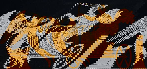
Hamilton - Engraving of a Painting from a Grecian Vase. 1Trillium Antique Prints & Rare Books4.5(30)See Sold PriceFeb 24, 2024
Hamilton - Engraving of a Painting from a Grecian VaseTrillium Antique Prints & Rare Books4.5(30)See Sold PriceFeb 24, 2024
Hamilton - Engraving of a Painting from a Grecian Vase. 2Trillium Antique Prints & Rare Books4.5(30)See Sold PriceFeb 24, 2024
Hamilton - Engraving of a Painting from a Grecian Vase. 32Trillium Antique Prints & Rare Books4.5(30)See Sold PriceFeb 24, 2024
Hamilton - Engraving of a Painting from a Grecian Vase. 114Trillium Antique Prints & Rare Books4.5(30)See Sold PriceFeb 24, 2024
Hamilton - Engraving of a Painting from a Grecian Vase. 5Trillium Antique Prints & Rare Books4.5(30)See Sold PriceFeb 24, 2024
Barthelemy, Jean 1790 Map. Greece - Essa sur la Bataille de PlateeAlbion Auctions4.6(336)See Sold PriceMar 01, 2024
Barthelemy, Jean 1790 Map. Greece - Plan de L'AcademieAlbion Auctions4.6(336)See Sold PriceMar 01, 2024
Barthelemy, Jean 1790 Map. Greece - Essai sur les Environs de DelphesAlbion Auctions4.6(336)See Sold PriceMar 01, 2024
1792 OLD INDIA HISTORY ANTIQUE ILLUSTRATED WITH MAPS OF THE EIGHTEENTH CENTURY IN FRENCHNY Elizabeth 4.3(84)See Sold PriceMar 03, 2024
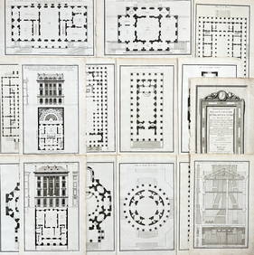
Jean-Francois de Neufforge (1714 - 1791) - Set of 15 Architecture Prints - Development pour unProverde Auctions4.3(3)See Sold PriceFeb 28, 2024
Jean-Francois de Neufforge (1714 - 1791) - Set of 15 Architecture Prints - Plan de l' EdificeProverde Auctions4.3(3)See Sold PriceFeb 28, 2024
Antique Map of Poland, 1700 by Guillaume De Lisle, ParisAntiques Online Auctions4.6(407)See Sold PriceMar 14, 2024