SoldMatthaus Seutter Map of Brazil 1735Matthaus Seutter Map of Brazil, 1735. Map titled "Recens elaborate Mappa Geographica Regni Brasiliae in America Meridionali". Map measures 23.75" x 20" sheet size. Unframed, loose and not glued or mouSee Sold Price
SoldMATTHAUS SEUTTER (GERMAN, 1678-1757) MAP OF BRAZILMATTHAUS SEUTTER (GERMAN, 1678-1757) MAP OF BRAZIL, hand-colored engraving on paper, titled "Recens Elaborata Mappa Geographica Regni Brasillae in America Meriodionali maxime celebris accurate delineaSee Sold Price
SoldSeutter: Antique Map of Portugal, Brazil Insert, 1740Title/Content of Map: Portugal with a magnificent cartouche and large insert of Brazil Date Printed: c1740 Cartographer: Matthaus Seutter Material/Medium: Paper Size: 23 1/2" x 19 2/3" Original hand cSee Sold Price
SEUTTER, Georg Matthaus (1678-1757) - Atlas novus siveSEUTTER, Georg Matthaus (1678-1757) - Atlas novus sive geographicae totius orbis faciem. Habsburg: Matthaus Seutter, [ca. 1735]. A copy in fine contemporary colouring of Seutter's celebrated atlas whiSee Sold Price
Seutter, Matthaus. General AtlasSeutter, Matthaus General Atlas C. 1735 Copperplate engraving; coloured Printed area: 54 x 34 cm; 21.3 x 13.5 in This 50 double-page engraved map-sheets includes a distance table and a plate containinSee Sold Price
Seutter, M. Novi Belgii, in America SeptentrionaliSeutter, Matthaus Recens edita totius Novi Belgii, in America Septentrionali siti, delineatio C. 1735 Copperplate engraving; old coloured Printed area: 57 x 49 cm; 22.4 x 19.3 in This map is based upoSee Sold Price
SoldMatthaus Seutter, Map, c. 1740Matthaus Seutter, "Mappa Geographica Regionem Mexicanam et Floridam...", Augsburg, c. 1740, hand-colored, with inset maps of Havana, Portobell, Cartagena and Vera Cruz, with vignettes of a sea battleSee Sold Price
SoldMatthaus Seutter, map OostendeMatthaus Seutter, map Oostende, Matthaus Seutter (German, 1678-1757), "Ostende", c. 1740, hand-colored engraving, 20"h x 23"w (sight), 31"h x 34"w (frame size), matted and framed under glass ProvenancSee Sold Price
SoldGeorge Matthaus Seutter, Map of RomeColored engraving. George Matthaus Seutter (1678-1757). Approx. 23" H x 26" W framed. (6090)See Sold Price
SoldMatthaus Seutter MapMatthaus Seutter, "Mappa Geographica Regionem Mexicanam et Floridam...", Augsburg, c. 1740, hand-colored, with inset maps of Havana, Portobell, Cartagena and Vera Cruz, with vignettes of a sea battleSee Sold Price
SoldGrp: 3 Matthaus Seutter Maps of Italy Tuscany ManMatthaus Seutter (1678-1757) Group of three hand colored maps including a map of Tuscany, a map of Mantua, and a map of Modena. All with exquisitely detailed cartouches featuring groups of figures. SKSee Sold Price
SoldMatthaus Seutter map of the Americas Austrian (167Matthaus Seutter map of the Americas Austrian (1678-1757) "Novus Orbis Sive America" hand-colored engraving. (Good condition, trimmed) paper size: H20 1/2" W24"See Sold Price
SoldMatthaus Seutter map of North AmericaCartographer: Matthaus Seutter Title: Accurata delineatio celeberrimae Regionis Ludovicianae vel Gallice Louisiane ol Canadae et Floridae adpellatione in Septemtrionali America descripta quae hodie noSee Sold Price
SoldMatthaus Seutter Map of France 1740Matthaus Seutter, Map of France, 1740. Titled "Provincia Gallis La Provence dicta". Measures 24-1/8" x 20.5" sheet size. Unframed, loose and not glued or mounted. Provenance: C.D. Raymond & Son collecSee Sold Price
Georg Matthaus Seutter map Lithuania LithuanianGeorg Matthaus Seutter I (1678 - 17560 ir Georg Matthaus Seutter (1729 - 1760) Novisima et accuratisima MAGNI DUCATUS LITHUANIe... Apie 1740, Augsburgas, Spalvintas vario raizinys, 49 x56,7See Sold Price
SoldMatthaus Seutter Map of Germany Saxony 1730Matthaus Seutter Map of Germany, Saxony, 1730. Titled "Saxoniae Inferioris Circulus Juxta Principatus et Status Suos Accurate Delineatus Cura et Stilo". Measures 23.75" x 20.5" sheet size. Unframed, lSee Sold Price
SoldSeutter Map of Czechoslovakia & Marovia 1678-1757Matthaus Seutter map of Czechoslovakia & Marovia, 1678-1757. Map titled "Moravia Marchionatus" Map measures 24" x 20.5" sheet size. Unframed, loose and not glued or mounted. Provenance: C.D. Raymond &See Sold Price
SoldGeorg Matthaus Seutter, Framed Map of CreteFramed map of Crete by map maker Georg Matthaus Seutter. Titled: Insula Creta nunc Candia, Date : Augsburg, 1741. Hand-colored map divided into its four territories, and the islands to its north. TheSee Sold Price
SoldMatthaus Seutter hand-colored mapMatthaus Seutter (German 1678-1757)- ''Tabula Comitatus Hollandiae... Provinc, ultraiectina et maxima pars Geldriae''- hand-colored map, cartouche top right, Texel map top left. 20 x 22 1/2''See Sold Price
Matthaus Seutter "Kriegs-Kunst" Map, 1720Matthaus Seutter "Kriegs-Kunst" Map, 1720, the hand colored map published by Seutter (German) showing where war materials, artillery, locksmiths and ships were located, appx. 24 1/8 in. H, 27 1/4 in.See Sold Price
Matthäus Seutter "Geographical map of diocese GroMatthäus Seutter "Geographical map of diocese Großenhain". Ca. 1750. Oldcoloured engraving map. Framed in mat with glass.Slightly wavily. Slight crinkles, minor water spots. Framed with slight damagSee Sold Price
[atlases] Seutter, 1735Seutter Georg Matthäus, Atlas Novus sive Tabulae Geographicae Totius Orbis... Augustae Vindelicorum: Matthäus Seutter, s.d. [1735 ca.]. In-folio (mm 530x320). 1 frontespizio allegorico, 2 carteSee Sold Price
SoldMaps, Matthaus Seutter and Frederick de Wit(lot of 2) Matthaus Seutter (German, 1678-1757), "Europa Religionis Christianae," copper engraved map with hand coloring and Frederick De Wit (Dutch,1630-1706), "Novissima et Accuratissima totius ItalSee Sold Price
SoldMap, Matthaus Seutter IIIMatthaus Seutter III (German, 1678-1757), "Praga Celeberrima et Maxima Totius Bohemiae Metropolis," circa 1720, hand-colored engraving, image (sight): 19.75"h x 22.75"w, overall (with mat/unframed): 2See Sold Price
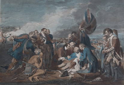
18TH C. ANTIQUE MAP: FRENCH & INDIAN WAR, FRAMEDThomaston Place Auction Galleries4.4(393)See Sold PriceFeb 24, 2024
Keith Haring - Ink on New York Map, Best Buddies, Inscribed, Signed, and DatedSapphire Auction Gallery4(67)See Sold PriceMar 02, 2024
Rand McNally Railroad Map Cabinet w/ 21 Railroad MapsRail & Road Auctions4.6(165)See Sold PriceMar 08, 2024
18th Century Hess Germany Hand colored Engraved MapGlobal Auctions Company4.3(36)See Sold PriceMar 03, 2024
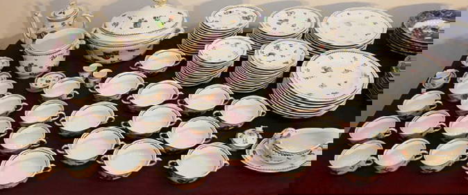
100 Pieces Of Ginori Italian Fruit 1735 ChinaRalph Fontaine Heritage Auctions Inc.4.7(236)See Sold PriceFeb 25, 2024
Photograph album of over 240 silverprints of Rio & Brazil 1944PBA Galleries4.7(385)See Sold PriceMar 07, 2024
William WOOLLETT, R.A.A. (1735 - 1785) BritishPridham's Auctions & Appraisals4.7(223)See Sold PriceMar 02, 2024


![[atlases] Seutter, 1735 (1 of 6)](https://p1.liveauctioneers.com/1306/149409/75467388_1_x.jpg?height=282&quality=70&version=1567670708)