SoldMatthaus Merian (Swiss, 1593-1650), engraving, Map ofMatthaus Merian (Swiss, 1593-1650), engraving, Map of Hala, Hall in Schwaben, 801/2" x 14-3/4" sight, 14-1/4" x 20-3/4" overall, center crease, light foxingSee Sold Price
SoldMatthaus Merian (Swiss, 1593-1650), engraving, Map ofMatthaus Merian (Swiss, 1593-1650), engraving, Map of Hala, Hall in Schwaben, 801/2" x 14-3/4" sight, 14-1/4" x 20-3/4" overall, center crease, light foxingSee Sold Price
SoldMATTHAUS MERIAN (SWISS/GERMAN, 1593-1650) MAP OF THEMATTHAUS MERIAN (SWISS/GERMAN, 1593-1650) MAP OF THE AMERICAS hand-colored engraving on laid paper, "America noviter delineata", published in Frankfurt after Jodocus Hondius's map of the same year. ReSee Sold Price
SoldMatthaus Merian (Swiss, 1593-1650), engraving,Matthaus Merian (Swiss, 1593-1650), engraving, Assassination of Wallenstein, 10 5/8" x 13 1/2" plate, 23" x 27" overall, center crease, even toningSee Sold Price
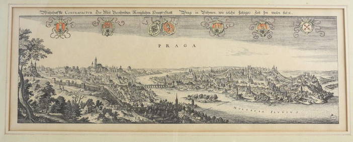
Merian, Matthaus Engraving Panoramic view of PragueMerian, Matthaus (Swiss 1593-1650) copper engraving on paper, 1650, "Wahrhaffte CONTRAFACTUR Der Weit Berühmbten Königlichen HauptStatt Prag in Böhmen, wie solche jetziger Zeit im Wesen stehtSee Sold Price
SoldMatthaus Merian,c.1638, India Orientalis MapMatthaus Merian, Swiss, 1593-1650, c.1638 Hand Colored Map of India Orientalis et Insulae Adiecentes (with early discoveries in Western Australia) includes Southeast Asia, China, India, the PhilippineSee Sold Price
SoldAfter Matthaus Merian, "La Citta di Venezia"After Matthaus Merian (Swiss, 1593-1650). "La Citta di Venezia". Hand-colored engraving. Sight: 17 3/4" x 31 7/8". Frame: 19 1/4" x 33 1/2". Hand-colored engraving by Matthaus Merian. Original image fSee Sold Price
Merian View of German TownscapesMERIAN, Matthaus (1593-1650) & Sons. Schweidnitz (Map). Engraving from Topographia Germaniae... Frankfurt, 1642-1688. 12 5/8" x 14 1/2" sheet.See Sold Price
SoldMatthäus Merian "Parys" Antique Engraving, 17th C.Matthäus Merian (Swiss, 1593-1650) "Parys (Paris) wie folche 1620 anzuleben gewesse", engraving on two joined sheets, 17th century, depicting panorama of the French capital with numeric list of imporSee Sold Price
SoldMatthaus Merian, China Map, c.1649Matthaus Merian, Swiss, 1593-1650, c.1649, China Veteribus Sinarum Regio nunc Incolis Tame dicta , map of China and Japan is closely modeled on Jansson's map of 1633. The detail includes the eastern pSee Sold Price
SoldMatthaus Merian (Swiss, 1593-1650) Gallia, Le RoyaumeMatthaus Merian (Swiss, 1593-1650) Gallia, Le Royaume de France, 1636 color engraving 10 3/4 x 14 inches. Provenance: Graham Arader Gallery, PhiladelphiaSee Sold Price
Matthäus Merian (Swiss-German, 1593-1650)Lot 386 Matthäus Merian (Swiss-German, 1593-1650) THREE TOPOGRAPHICAL VIEWS OF GERMAN CITIES, EARLY 17TH CENTURY Dörnberg, Salfeldt and Mansfeld, each a copperplate engraving on laid paper, framed sSee Sold Price
Matthäus Merian (Swiss-German, 1593-1650)Lot 338 Matthäus Merian (Swiss-German, 1593-1650) THREE TOPOGRAPHICAL VIEWS OF GERMAN CITIES, EARLY 17TH CENTURY Dörnberg, Salfeldt and Mansfeld, each a copperplate engraving on laid paper, framed sSee Sold Price
SoldMap: nova descriptio Africae, c. 1638Map: nova descriptio Africae, c. 1638, Merian the Elder [Mathaus Merian] (Swiss, 1593-1650), hand-colored engraving on paper, 12.75"h x 14.75"w (sheet), 17"h x 19"w (frame)See Sold Price
SoldPortfolio, Matthäus Merian the ElderMatthäus Merian the Elder (Swiss, 1593–1650), "Die schönsten Städtebilder aus Deutschland, Österreich und der Schweiz," 1966, portfolio of maps originally created by Matthaus Merian, overall (wiSee Sold Price
Map of 1631 Breitenfeld Battle. Engraving 1646Title/Content of Map:Map of 1631 Breitenfeld Battle. Engraving 1646 Date: 1646 Cartographer: Merian Matthaus (1593-1650). Copper Engraving by Engraver Olaf Hanson. Material/Medium: 2-plates copper engSee Sold Price
SoldMatthäus Merian, Birds-Eye View of “Franckfurt”, 1645Original copperplate engraving Merian, Frankfurt on the Main, 1645 Matthäus Merian (1593-1650) – Swiss-German engraver and publisher Framed under mat Dimensions, framed: 45 x 53 cm Plate size: 35 xSee Sold Price
SoldCity view of Leeuwarden, M. Merian, 17th CenturyCopperplate engraving on paper, additional colouration Germany, 17th Century Matthäus Merian (1593-1650) – Swiss-German engraver and publisher Dimensions: 20 x 30.3 cm Estimate by Auctionata ExpertSee Sold Price
SoldMatthaus Merian (1593-1650 Swiss) ''Zwolf Monate''Matthaus Merian (1593-1650 Swiss) ''Zwolf Monate'' (The Twelve Months of the Year) Set of (12) Engravings 5.25''x6.5'' Each. Trimmed to Plate Mark.See Sold Price
Matthaus Merian Map, Listed Artist,(1593-1650)Matthaus Merian Map, Listed Artist,(1593-1650) Copper Plate Engraving of Heidelberg Germany On Laid Paper, Inscribed 1620. No Information Is Available On The Exact Date This Image Was Pulled. Framed 3See Sold Price
SoldEngraving Matthaus Merian After Kupferstich "Rotenburg"8 1/2" X 12 1/2" matted in a 17" X21" frame, wood engraving by Matthaus Merian (1593-1650) after Kupferstich, Rotenburg, map has a stain and was folded with a crease tear, matte has stains and frame hSee Sold Price
Merian Map of the WorldNova Totius Terrarum Orbis Geographica ac Hydrographica Tabula. Matthaus Merian (1593-1650). Engraved map. Frankfurt, after 1638. 10 3/4 x 14 1/4 inches sheet, 20 x 23 1/2 inches framed. Matthaus MeriSee Sold Price
Sold17th century engraving by MerianMattaus Merian, Swiss, 1593-1650. Engraving with landscape entitled "Near Zurich". Signed "M Merian, fecit" in the plate lower right. Some toning and discoloration. Image 5 3/4 x 4 3/4". ESTIMATE $200See Sold Price
Att. To M. Merian Town ViewAttributed to Matthaus Merian, Swiss, 1593-1650. Etching on watermarked paper (possibly a Foolscap) depicting a village scene with figures in the foreground. No signature or other markings. Paper hasSee Sold Price
LATE 17TH C. FRENCH MAP OF THE NEW WORLD BY ALEXIS-HUBERT JAILLOT (1632-1712)Thomaston Place Auction Galleries4.4(394)See Sold PriceFeb 24, 2024
MAP - PIETER SCHENK / VALK / JANSSEN Hand Colored superb Map Central Italy c1702Luis Porretta Fine Arts4.3(10)See Sold PriceMar 02, 2024
DEVINE c1856 Dr Salters Map Of Lake Huron Ontario Indian Lands etc. No. 7 ScarceLuis Porretta Fine Arts4.3(10)See Sold PriceMar 02, 2024
MATTHEWS c1856 Map Of Upper Canada Ontario Indian Land Agency Divisions Scarce!Luis Porretta Fine Arts4.3(10)See Sold PriceMar 02, 2024
Vintage County Map Of NY State Plate EngravingThe Benefit Shop Foundation Inc.4.3(3k)See Sold PriceFeb 28, 2024
Matthaus Merian (Swiss 1593-1650) Engraving Panoramic View of PragueGlobal Auctions Company4.3(36)See Sold PriceMar 03, 2024
An early Dutch hand colored engraving map by Georg Balthasar Probst (1732-1801)Ostantix Auctions4.4(11)See Sold PriceFeb 27, 2024
De Jode, Rare, pub. 1593 - Map of Italy (Italiae Totius Orbis olim Domatricis Nova ExactissTrillium Antique Prints & Rare Books4.5(33)See Sold PriceFeb 24, 2024
De Jode, Rare, pub. 1593 - Map of the Czech Republic or Kingdom of Bohemia (Chorographia insignisTrillium Antique Prints & Rare Books4.5(33)See Sold PriceFeb 24, 2024
De Jode, Rare, pub. 1593 - Map of the Middle East, Eastern Asia (Primae Partis Asiae accurataTrillium Antique Prints & Rare Books4.5(33)See Sold PriceFeb 24, 2024
De Jode, Rare, pub. 1593 - Map of Africa (Africae Vera Forma, et Situs)Trillium Antique Prints & Rare Books4.5(33)See Sold PriceFeb 24, 2024
Karl Bodmer - A Young Mandan Indian. 24Trillium Antique Prints & Rare Books4.5(33)See Sold PriceFeb 24, 2024
Karl Bodmer - Assinboin Indians. 32Trillium Antique Prints & Rare Books4.5(33)See Sold PriceFeb 24, 2024
Karl Bodmer - Scalp Dance of the Minatarres. 27Trillium Antique Prints & Rare Books4.5(33)See Sold PriceFeb 24, 2024
After Matthaus Merian (1593-1650), Engraving with hand colouring, Ander Prost: der Kirche de R. P.Claydon Auctioneers Ltd4.3(125)See Sold PriceFeb 26, 2024