SoldMAP - Pittsburgh, Pennsylvania. BernhardPittsburgh, Pennsylvania. Carl Bernhard, Plan von Pittsburg und Umgebungen, 1828 (circa). Hand Color. This detailed map of the Pittsburgh region was published in a German book describing the travels oSee Sold Price
SoldStreet Map Pittsburgh, Pennsylvania, in 1795Title: A street map of Pittsburgh, Pennsylvania, in 1795, which includes Fort Pitt From an original map by J. W. Johnten Esq. Medium: early lithography Dimensions: 15.5 x 23.25 inches Provenance: EverSee Sold Price
Pittsburgh 1889Title/Content of Map: Pittsburgh 1889 Date Printed: 1889 Material/Medium: paper Size: approx 21.5x14 inches W.H. Stewart Publishing, Rochester NY Reserve: $30.00 Shipping: Domestic: Flat-rate of $15.See Sold Price
SoldCram's Map of Pittsburgh (and Allegheny City), 1887Map: Pittsburgh (and Allegheny City) Maker: George F. Cram Date: 1887 Size: 21.5 x 14.5 in Please note that this lot has a confidential reserve. When you leave a bid in advance of the auction, submitSee Sold Price
Pittsburgh 1889Title/Content of Map: Pittsburgh 1889 Date Printed: 1889 Material/Medium: paper Size: approx 21.5x14 inches W.H. Stewart Publishing, Rochester NY Reserve: $35.00 Shipping: Domestic: Flat-rate of $15.See Sold Price
Pittsburgh 1889Title/Content of Map: Pittsburgh 1889 Date Printed: 1889 Material/Medium: paper Size: approx 21.5x14 inches Additional Info: W.H. Stewart Publishing, Rochester NY Reserve: $30.00 Shipping: Domestic: FSee Sold Price
Pittsburgh 1889Title/Content of Map: Pittsburgh 1889 Date Printed: 1889 Material/Medium: paper Size: approx 21.5x14 inches Additional Info: W.H. Stewart Publishing, Rochester NY Reserve: $30.00 Shipping: Domestic:See Sold Price
Colton: Antique Map of Pittsburgh & Cincinnati, 1859Title/Content of Map: Pittsburgh & Cincinnati by Colton Date Printed: 1859 Cartographer: H. J. Colton Material/Medium: Paper Size: 17 1/2" x 15" Hand colored engraved. Published in New York in 'ColtonSee Sold Price
Colton: Antique Map of Pittsburgh & Cincinnati, 1861Title/Content of Map: Pittsburgh & Cincinnati Date Printed: 1861 Cartographer: J. H. Colton Material/Medium: Paper Size: 13" x 17 Hand colored, steel engraved. From 'Colton's General Atlas. PublishedSee Sold Price
Pittsburgh 1889Title/Content of Map: Pittsburgh 1889 Date Printed: 1889 Material/Medium: paper Size: approx 21.5x14 inches W.H. Stewart Publishing, Rochester NY Reserve: $35.00 Shipping: Domestic: Flat-rate of $15.See Sold Price
Sold1914 Plat Map of Pittsburgh Allegheny River BankArtist: G. M. Hopkins Company Maps Title: 1914 Plat Map of Pittsburgh Allegheny River Bank with Jos. Hornes, Fulton Building, and (Thomas) Jenkins Building (Arcade) Date: 1914 Medium: lithography DimeSee Sold Price
SoldColton: Antique Map of Pittsburgh & Cincinnati, 1861Title/Content of Map: Pittsburg and Cincinnati Date Printed: 1861 Cartographer: J.H. Colton Material/Medium: Paper Size: 13" x 8 1/2" Hand colored, steel engraved. From Colton's 'General Atlas'. PubliSee Sold Price
SoldHand colored Map of Pittsburgh & CincinnatiGray's Atlas Map of Pittsburgh & Allegheny County and Cincinnati, Ohio Depicts railroad lines, common roads, canals, topography, etc. A beautiful & rare map. Cartographer: <See Sold Price
Sold1874 Colton Map of Pittsburgh and Cincinnati -- TheTitle/Content of Map: 1874 Colton Map of Pittsburgh and Cincinnati -- The Cities of Pittsburgh with Allegheny [on a sheet with] The City of Cincinnati Date: 1874 Philadelphia Cartographer: J Colton SiSee Sold Price
1887 Map of PittsburghAuthor: Cram Title: 1887 Map of Pittsburgh Medium: Ink on Paper Dimensions: 22"X15" Map of Pittsburgh dated 1887. Engraved and published by George Cram in Chicago. Part of his World Atlas. Double foliSee Sold Price
SoldHand colored Map of Pittsburgh & CincinnatiGray's Atlas Map of Pittsburgh & Allegheny County and Cincinnati, Ohio Depicts railroad lines, common roads, canals, topography, etc. A beautiful & rare map.See Sold Price
SoldHand colored Map of Pittsburgh & CincinnatiGray's Atlas Map of Pittsburgh & Allegheny County and Cincinnati, Ohio Depicts railroad lines, common roads, canals, topography, etc. A beautiful & rare map. Maker:See Sold Price
Colton: Antique Map of Pittsburgh and Cincinnati, 1874Title/Content of Map: 1874 Colton Map of Pittsburgh and Cincinnati -- The Cities of Pittsburgh with Allegheny [on a sheet with] The City of Cincinnati Date Printed: 1874 Philadelphia Cartographer: J CSee Sold Price
SoldHand colored Map of Pittsburgh & CincinnatiGray's Atlas Map of Pittsburgh & Allegheny County and Cincinnati, Ohio Depicts railroad lines, common roads, canals, topography, etc. A beautiful & rare map. CartogrSee Sold Price
Hand colored Map of Pittsburgh & CincinnatiGray's Atlas Map of Pittsburgh & Allegheny County and Cincinnati, Ohio Depicts railroad lines, common roads, canals, topography, etc. A beautiful & rare map. Maker: OSee Sold Price
Rand-Mcnally New Commercial Atlas Map of Pittsburgh.Title: Rand-Mcnally New Commercial Atlas Map of Pittsburgh. Publication Date: 1912 Cartographer: RAND-MCNALLY & COMPANY Publisher: RAND MCNALLY & CO. Size: 19Height - 25.75Width Page 62-63 from The LiSee Sold Price
Hand colored Map of Pittsburgh & CincinnatiGray's Atlas Map of Pittsburgh & Allegheny County and Cincinnati, Ohio Depicts railroad lines, common roads, canals, topography, etc. A beautiful & rare map. Maker: OSee Sold Price
Hand colored Map of Pittsburgh & CincinnatiGray's Atlas Map of Pittsburgh & Allegheny County and Cincinnati, Ohio Depicts railroad lines, common roads, canals, topography, etc. A beautiful & rare map.See Sold Price
Hand colored Map of Pittsburgh & CincinnatiGray's Atlas Map of Pittsburgh & Allegheny County and Cincinnati, Ohio Depicts railroad lines, common roads, canals, topography, etc. A beautiful & rare map.See Sold Price
Crawfordsville and Southwestern RY First Mortgage Bond Prospectus Book-1872JM Hobby Supply and Railroad Artifact Auctions4.4(126)See Sold PriceFeb 24, 2024
Cincinnati Hamilton and Dayton RR Map -USGC 1889JM Hobby Supply and Railroad Artifact Auctions4.4(126)See Sold PriceFeb 24, 2024
Fort Wayne and Pennsylvania RR 1880 Public TimetableJM Hobby Supply and Railroad Artifact Auctions4.4(126)See Sold PriceFeb 24, 2024
Pennsylvania Central/Pittsburgh Ft Wayne and Chicago 1870 Public TimetableJM Hobby Supply and Railroad Artifact Auctions4.4(126)See Sold PriceFeb 24, 2024
1885 CIVIL WAR 1ed Famous Memoirs US Grant Sheridan Sherman 6v RARE LOT MapsSchilb Antiquarian Rare Books4.8(421)See Sold PriceMar 10, 2024
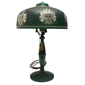
Pittsburgh Reverse Painted Harbor Scene LampPremier Auction Galleries4.3(329)See Sold PriceMar 09, 2024
Art Deco Pittsburgh Lamp with Green Cased ShadePremier Auction Galleries4.3(329)See Sold PriceMar 09, 2024
Large lot of assorted prints. 18th-20th century. To include: North American and other maps, CivilTremont Auctions4.6(293)See Sold PriceFeb 25, 2024
1888 Hand Book of the Pennsylvania Lines Containing Maps of Principal Cities - First EditionRail & Road Auctions4.6(165)See Sold PriceMar 07, 2024
Pair of Early Railroad Maps - 1862 Pittsburgh, Ft. Wayne & Chicago Railway and 1873 PennsylvaniaRail & Road Auctions4.6(165)See Sold PriceMar 07, 2024
Collection of Allied Military Silk Printed Maps, WWII Era and LaterMaterial Culture4.6(765)See Sold PriceFeb 29, 2024
Rand McNally Railroad Map Cabinet w/ 21 Railroad MapsRail & Road Auctions4.6(165)See Sold PriceMar 08, 2024
Willem Blaeu, Etc. 17th C. Antiquarian Maps, 2Auctions at Showplace4.5(726)See Sold PriceMar 17, 2024
[MUSIC]. JONES, Paul T., photographer. Billie Holiday performing at the Bambola in Pittsburgh, PA.Freeman's | Hindman4.4(1.6k)See Sold PriceFeb 27, 2024
Putnam - First Map of the State of Ohio by Rufus PutnamTrillium Antique Prints & Rare Books4.5(30)See Sold PriceFeb 24, 2024
De Jode, Rare, pub. 1593 - Map of Africa (Africae Vera Forma, et Situs)Trillium Antique Prints & Rare Books4.5(30)See Sold PriceFeb 24, 2024
George F. Cram - Historical Map of Pittsburgh Allegheny PennsylvaniaProverde Auctions4.3(3)See Sold PriceFeb 28, 2024
Vintage Street Map of Pittsburgh, Pennsylvania - Rand McNallyProverde Auctions4.3(3)See Sold PriceFeb 28, 2024


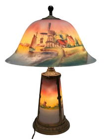


![[MUSIC]. JONES, Paul T., photographer. Billie Holiday performing at the Bambola in Pittsburgh, PA. (1 of 2)](https://p1.liveauctioneers.com/197/319238/171467974_1_x.jpg?height=282&quality=70&version=1707520367)


