SoldMaps: A set of c1939 Bartholomew's Map of England andMaps: A set of c1939 Bartholomew's Map of England and Wales, on linen, scale 2 miles to 1 inch in leather case. Each map 7 1/2'' x 4 1/4''. (42)See Sold Price
SoldMaps: A set of c1939 Bartholomew's Map of England andMaps: A set of c1939 Bartholomew's Map of England and Wales, on linen, scale 2 miles to 1 inch in leather case. Each map 7 1/2'' x 4 1/4''. (42)See Sold Price
SoldBARTHOLOMEW MAPS OF ENGLAND & WALES w/ CASEOriginal set of Bartholomew's Maps of England and Wales. Includes set 1-37. Only map 36 is missing. Comes in original leather case with compass. 16" ExcellentSee Sold Price
A set of Bartholomew's road maps for England and Wales,A set of Bartholomew's road maps for England and Wales, early 20th century, in a light tan crocodile skin case with gilt tooling and initialled 'JW', with a single handle to the cover and gilt brass lSee Sold Price
SoldBartholomew's Maps of England & WalesComplete set of 37 original rexine Bartholew's maps, which cover the whole of England & Wales. Presented in original four compartment leather satchel with gold leaf index book & keys. Satchel dated 19See Sold Price
Bartholomew: Map of New England States &c., 1898Map: New England States &c. Date: 1898 Size: 18 x 14 inches From Bartholomew's "The Citizen's Atlas of the World". Insets of Philadelphia, Environs of New York, Saint Louis, Niagra Falls, Chicago, BosSee Sold Price
SoldRichard William Seale (1732-1775), "Foldable 3 Map SetRichard William Seale (1732-1775), "Foldable 3 Map Set of England, Ireland, and Scotland," 1750, paper on linen, Each.- H.- W. - 46 in. (3 Pcs.)See Sold Price
SoldBartholomew: Antique Map of England & Wales, 1890Title/Content of Map: England & Wales Date Printed: 1890 Cartographer: BARTHOLOMEW, JOHN & CO. Size (inches): 11.25X11.6 "By J. Bartholomew, F.R.G.S." Polar projection. 11 Shows nautical routes. FromSee Sold Price
Bartholomew's General Map of England & WalesTitle: Bartholomew's General Map of England & Wales Date: c1930 Cartographer: BARTHOLOMEW, JOHN & SONS Publisher: THE EDINBURGH GEOGRAPHICAL INSTITUTE, JOHN BARTHOLOMEW & CO. Size: 41.25Height - 32WidSee Sold Price
SoldMaps: A collection of 7 maps. Including: Bartholomew'sMaps: A collection of 7 maps. Including: Bartholomew's Contoured Road Map of England and Wales , Fourth edition, mounted on cloth. An Ordnance Survey One- Inch map of Great Britain ; London N.W . SeveSee Sold Price
SoldMaps: A collection of 7 maps. Including: Bartholomew'sMaps: A collection of 7 maps. Including: Bartholomew's Contoured Road Map of England and Wales , Fourth edition, mounted on cloth. An Ordnance Survey One- Inch map of Great Britain ; London N.W . SeveSee Sold Price
SoldMaps: A collection of 7 maps. Including: Bartholomew'sMaps: A collection of 7 maps. Including: Bartholomew's Contoured Road Map of England and Wales , Fourth edition, mounted on cloth. An Ordnance Survey One- Inch map of Great Britain ; London N.W . SeveSee Sold Price
SoldFramed Antique Map Of City & HarborsCities include Boston, New York, Baltimore, Portland, Hudson River, and Philadelphia. Type along top reads ‘Northern Ports & Harbours in the United States, By J. Bartholomew.’ Map is set behind glSee Sold Price
SoldA set of Bartholomew's road maps for Scotland, earlyA set of Bartholomew's road maps for Scotland, early 20th century, in a light tan crocodile skin case with gilt tooling and initialled 'JW', with a single handle to cover and gilt brass lock and catchSee Sold Price
SoldCyclist touring map of England & Wales pre. 1900Original Bartholomew’s cyclists’ touring map of England & Wales circa shortly before 1900. Mounted on board, not framed. Excellent condition, rare item. Measures: 33” tall X 27” wide.See Sold Price
Historic J. Bartholomew Map, Folio from LibraryDescription: Folio from the Library Reference Atlas, page 14, Map of England & Wales, section 3 by John Bartholomew & Co. Born in Edinburgh in 1831, John Bartholomew was a noted Scottish cartographer.See Sold Price
Historic J. Bartholomew Map, Folio from LibraryDescription: Folio from the Library Reference Atlas, page 15, Map of England & Wales, section 4 by John Bartholomew & Co. Born in Edinburgh in 1831, John Bartholomew was a noted Scottish cartographer.See Sold Price
Historic J. Bartholomew Map, Folio from LibraryDescription: Folio from the Library Reference Atlas, page 15, Map of England & Wales, section 4 by John Bartholomew & Co. Born in Edinburgh in 1831, John Bartholomew was a noted Scottish cartographer.See Sold Price
Historic J. Bartholomew Map, Folio from LibraryDescription: Folio from the Library Reference Atlas, page 14, Map of England & Wales, section 3 by John Bartholomew & Co. Born in Edinburgh in 1831, John Bartholomew was a noted Scottish cartographer.See Sold Price
Historic J. Bartholomew Map, Folio from LibraryDescription: Folio from the Library Reference Atlas, page 15, Map of England & Wales, section 4 by John Bartholomew & Co. Born in Edinburgh in 1831, John Bartholomew was a noted Scottish cartographer.See Sold Price
Historic J. Bartholomew Map, Folio from LibraryDescription: Folio from the Library Reference Atlas, page 14, Map of England & Wales, section 3 by John Bartholomew & Co. Born in Edinburgh in 1831, John Bartholomew was a noted Scottish cartographer.See Sold Price
Sold1800 The British Tourist Six Vol Set MapsThe British Tourist or Traveller's Pocket Companion Through England, Wales, Scotland, and Ireland.., by William Mavor, printed at London for E. Newberry (others) 1800. Three volumes with folding mapsSee Sold Price
SoldToms & Badeslade 1742 Hand Coloured Map of Worcester"A Map of Worcestershire" Hand Coloured Copper Engraved Map Published 1742, London for "Chorographia Britanniae, or a set of maps of all the counties in England and Wales" by Thomas Badeslade & WilliaSee Sold Price
SoldToms & Badeslade C1742 Hand Col Map of StaffordshireHand Colored Copper Engraved Map Published C1742, London for "Chorographia Britanniae, or a Set of Maps of all the Counties in England and Wales" by Thomas Badeslade and William Henry Toms. Paper SizeSee Sold Price
A Mickey Mouse Club Mattel Musical Map Record Set.Van Eaton Galleries4.6(99)See Sold PriceMar 02, 2024
AFRICA. French West Africa. Rio de Oro Rio Muni Nigeria. BARTHOLOMEW 1952 mapJasper524.5(9.9k)See Sold PriceFeb 28, 2024
AFRICA. Pre 'Scramble for Africa'. BARTHOLOMEW 1876 old antique map plan chartJasper524.5(9.9k)See Sold PriceFeb 28, 2024
Algeria Morocco & Tunis. North Africa. Tunisia. Maghreb. BARTHOLOMEW 1898 mapJasper524.5(9.9k)See Sold PriceFeb 28, 2024
COLONIAL CENTRAL AFRICA. Congo German East Africa Rhodesia. BARTHOLOMEW 1898 mapJasper524.5(9.9k)See Sold PriceFeb 28, 2024
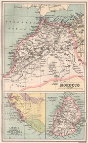
MOROCCO LIBERIA & MAURITIUS. Sierra Leone. BARTHOLOMEW 1886 old antique mapJasper524.5(9.9k)See Sold PriceFeb 28, 2024
Central Africa. Congo Zambia Tanzania Kenya Mozambique. BARTHOLOMEW 1886 mapJasper524.5(9.9k)See Sold PriceFeb 28, 2024
NORTH AFRICA. Morocco Algeria Tunis Tunisia Egypt. Cairo. BARTHOLOMEW 1912 mapJasper524.5(9.9k)See Sold PriceFeb 28, 2024
NORTH AFRICA. Morocco Algeria Tunis Tunisia Egypt. Cairo. BARTHOLOMEW 1901 mapJasper524.5(9.9k)See Sold PriceFeb 28, 2024
NORTH AFRICA. Algeria Morocco Tunis Tunisia Maghreb. BARTHOLOMEW 1891 old mapJasper524.5(9.9k)See Sold PriceFeb 28, 2024
Set of 4 Maps - Netherlands - Seven United Provinces - Germany - Sweden, Denmark, Norway, FinlandProverde Auctions4.3(3)See Sold PriceFeb 28, 2024
Set of 3 Maps - Netherlands - Belgien - Switzerland - J. BarlowProverde Auctions4.3(3)See Sold PriceFeb 28, 2024