Sold[Map/Europe]. Grande Carte De L'Europe. Turin[Map/Europe]. Grande Carte De L'Europe. Turin: 1852. Sectional map of Europe in 9 sheets, incomplete. Each sheet about 13 1/4 x 16 3/4 inches, some areas colored. Should be seen.See Sold Price
1930 Grande Carte de L'Europe CentraleA 1930 Map of Central Europe, designed and printed for bicycling and automotive routes. Large folding map.See Sold Price
1930 Grande Carte de LA 1930 Map of Central Europe, designed and printed for bicycling and automotive routes. Large folding map.See Sold Price
1861 Nouvelle Carte Illustre de l'Europe Presentant lesThis is an authentic, antique map Europe by A. Vuillem. The map was published out of Paris and is dated 1861. A handsome, large chart from this scarce nineteenth century atlas, Geographie CommercialeSee Sold Price
1861 Nouvelle Carte Illustre de l'Europe Presentant lesBy: A. Vuillemin Date: 1861 (dated) Paris Dimensions: 33.3 x 23.6 inches (84.6 x 60.0 cm) This is an authentic, antique map Europe by A. Vuillem. The map was published out of Paris and is dated 1861.See Sold Price
1861 Nouvelle Carte Illustre de l'Europe Presentant lesBy: A. Vuillemin Date: 1861 (dated) Paris Dimensions: 33.3 x 23.6 inches (84.6 x 60.0 cm) This is an authentic, antique map Europe by A. Vuillem. The map was published out of Paris and is dated 1861.See Sold Price
1861 Nouvelle Carte Illustre de lThis is an authentic, antique map Europe by A. Vuillem. The map was published out of Paris and is dated 1861. A handsome, large chart from this scarce nineteenth century atlas, Geographie CommercialeSee Sold Price
Lapie: Carte de l'Europe, 1833Carte de l'Europe. The highly detailed Europe map from the first edition of Lapie's influential Atlas Universel. Adorned by an elegant title cartouche, the superbly engraved map encompasses the entireSee Sold Price
SoldCarte de l'Europe"Carte de l'Europe Suivant Les Plus Nouvelles Observations de Messieurs de L'Academic des Sciences Et des Princi...", hand-colored engraved map of Europe from Henri Chatelain, Atlas Historique, LondonSee Sold Price
SoldPierre Lapie (1779-1850), "Carte De L'Europe sousPierre Lapie (1779-1850), "Carte De L'Europe sous Charlemagne and sous Charles-Quint," 1831; "Carte De Europe en 1789 and en 1813," 1831; and "Carte De L'Europe Avant L'Invasion Des Barbares, and ApreSee Sold Price
Sold Carte de l'Europe suivant les plus Nouvelles ObservatCarte de l'Europe suivant les plus Nouvelles Observations de Messieurs de l'Academie des Sciences et des Principaux Geographes avec des Tables et de Nouvelles Instructions ... Kupferstichkarte aus ChaSee Sold Price
SoldChatelain (Henri Abraham) Carte De L'Europe SuivanChatelain (Henri Abraham) Carte de l'Europe suivant les plus nouvelles Observationsde Messieurs de L'Academie des Sciences..., hand-coloured engraved map, 480 x 600mm, [c.1720] § Bowen (EmanueSee Sold Price
Carte de L'Europe. Map of Europe. MALTE-BRUN c1871 oldTITLE/CONTENT OF MAP: 'Carte de l'Europe [Map of Europe]' DATE PRINTED: c1871 IMAGE SIZE: Approx 33.5 x 46.5cm, 13.25 x 18.25 inches (Large); Please note that this is a folding map. TYPE: Antique 19thSee Sold Price
SoldPierre Lapie (1779-1850), "Carte De L'Europe sousPierre Lapie (1779-1850), "Carte De L'Europe sous Charlemagne and sous Charles-Quint," 1831; "Carte De Europe en 1789 and en 1813," 1831; and "Carte De L'Europe Avant L'Invasion Des Barbares, and ApreSee Sold Price
Carte de L'Europe. Map of Europe. MALTE-BRUN c1871 old antique plan chartTITLE/CONTENT OF MAP: 'Carte de l'Europe [Map of Europe]' DATE PRINTED: c1871 IMAGE SIZE: Approx 33.5 x 46.5cm, 13.25 x 18.25 inches (Large); Please note that this is a folding map. TYPE: Antique 19thSee Sold Price
Carte De L'europeTitle: Carte De L'europe Publication Date: c1820 Cartographer: ANONYMOUS. FRENCH Publisher: Dimension: 7.25Height - 8.6Width Anonymous geography map, about 1820, although still struck on laid paper. VSee Sold Price
Lapie: Carte de l'Europe, 1833Map: Carte de l'Europe Cartographer: Lapie Place & Date: Paris / 1833 Size: 21 1/2" x 15 7/8" Condition: outline color; light overall age toning and minor spotting, mostly in margins; repaired split iSee Sold Price
Carte De L'europeReserve Reduced! Title: Carte De L'europe Publication Date: c1820 Cartographer: ANONYMOUS. FRENCH Publisher: Size: 7.25X8.6 Anonymous geography map, about 1820, although still struck on laid paper. VaSee Sold Price
Carte De L'europePublication Date: c1820 Title: Carte De L'europe Cartographer: ANONYMOUS. FRENCH Height: 7.25 Width: 8.6 Anonymous geography map, about 1820, although still struck on laid paper. Vague national boundaSee Sold Price
Carte de L'Europe. Map of Europe. MALTE-BRUN c1871 old antique plan chartTITLE/CONTENT OF MAP: 'Scandinavia, or Sweden, Denmark and Norway' DATE PRINTED: 1830 IMAGE SIZE: Approx 60.5 x 51.0cm, 23.75 x 20 inches (Large); Please note that this is a folding map. TYPE: AntiqueSee Sold Price
SoldMap of Europe. 1854.Print of hand colored steel engraving titled „Carte de L’Europe”.Drawn by L. Dussieux. Engraved by unknown.From „Atlas General De Geographie physique, politique et historique par L. Dussieux.See Sold Price
SoldAnville (J.B.B. d') composite atlasAnville (Jean Baptiste Bourguignon d') Composite atlas,35 maps sheets to form 20 maps, including the Première, Seconde, and Troisième parties de la Carte de l'Europe, the Première, Seconde andSee Sold Price
Sold(MAP) PALAIRET, JEAN. A group of 2 hand-colored maps(MAP) PALAIRET, JEAN Two engraved maps with hand-coloring from Atlas methodique, by J. Palairet, (London, c. 1755), comprising Ie. Carte de l'Europe, 1754, and Ie. Carte des sept provinces unies desSee Sold Price
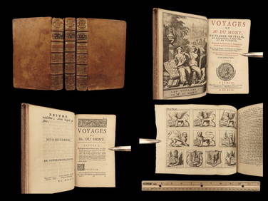
1699 Jean Dumont VOYAGES in France Italy Germany ROME Malta Turkey Ottoman 3vSchilb Antiquarian Rare Books4.8(422)See Sold PriceMar 31, 2024
Van Houtte - Lady's Slipper OrchidTrillium Antique Prints & Rare Books4.5(30)See Sold PriceFeb 24, 2024
Railways & Transport.- [Prospectus] The Dorking, Brighton, and Arundel Atmospheric Railway, byForum Auctions4.3(53)See Sold PriceFeb 29, 2024
Van Houtte (Pub) C1860 Pair of Folio Greenhouse Prints. BelgiumAlbion Auctions4.6(341)See Sold PriceMar 07, 2024
1764 Bellin Map of Mari-Galante Near Guadeloupe -- Carte de l'Isle de Mari-GalanteJasper524.5(9.8k)See Sold PriceFeb 27, 2024
1764 Bellin Map of St. Kitts -- Carte de l'Isle St. ChristopheJasper524.5(9.8k)See Sold PriceFeb 27, 2024
1764 Bellin Map of Antigua -- Carte de l'Isle d'Antigue Situee par la Latitude 17 Degres et par laJasper524.5(9.8k)See Sold PriceFeb 27, 2024
1845 Delisle/Bauche Map of Martinique -- Carte de l'Isle de la Martinique Colonie Francoise de l'uneJasper524.5(9.8k)See Sold PriceFeb 27, 2024
RAVEL MAURICE: (1875-1937)International Autograph Auctions Europe S.L.4.5(52)See Sold PriceMar 13, 2024
DORE GUSTAVE: (1832-1883)International Autograph Auctions Europe S.L.4.5(52)See Sold PriceMar 14, 2024
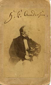
ANDERSEN HANS CHRISTIAN: (1805-1875)International Autograph Auctions Europe S.L.4.5(52)See Sold PriceMar 14, 2024
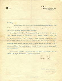
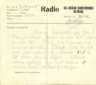
MERMOZ JEAN: (1901-1936)International Autograph Auctions Europe S.L.4.5(52)See Sold PriceMar 14, 2024
CHRISTINE OF FRANCE: (1606-1663)International Autograph Auctions Europe S.L.4.5(52)See Sold PriceMar 14, 2024
WILHELM KARL: (1864-1928)International Autograph Auctions Europe S.L.4.5(52)See Sold PriceMar 14, 2024
[ALEXANDER III]: (1845-1894)International Autograph Auctions Europe S.L.4.5(52)See Sold PriceMar 14, 2024
1939 A La Conquete De L'europe Softcover BookRapid Estate Liquidators and Auction Gallery4.5(1.1k)See Sold PriceFeb 27, 2024
![[Map/Europe]. Grande Carte De L'Europe. Turin First Image](https://p1.liveauctioneers.com/dist/images/placeholder.jpg?height=282&quality=95&width=282)
![[Map/Europe]. Grande Carte De L'Europe. Turin (1 of 0)](https://p1.liveauctioneers.com/dist/images/placeholder.jpg?height=282&quality=70)
![[Map/Europe]. Grande Carte De L'Europe. Turin First Image](https://p1.liveauctioneers.com/dist/images/placeholder.jpg?height=282&quality=1&width=282)


![Railways & Transport.- [Prospectus] The Dorking, Brighton, and Arundel Atmospheric Railway, by (1 of 1)](https://p1.liveauctioneers.com/5458/319736/171654703_1_x.jpg?height=282&quality=70&version=1708010439)


![[ALEXANDER III]: (1845-1894) (1 of 2)](https://p1.liveauctioneers.com/1458/320148/172030958_1_x.jpg?height=282&quality=70&version=1708367366)

